

.jpg "Sẽ có 336 căn hộ nhà ở xã hội tại khu đô thị phía nam TP Hải Dương")

.jpg "Real estate market in the south of Hai Duong city is bustling")
")

")
 decreased by more than 50% compared to 1 month ago.")
.jpg "Hai Duong issues economic and technical norms to prepare land valuation estimates")


.jpg "Extremely dangerous forest fire risk in Kinh Mon, Chi Linh")


-ac017d3d3ce25d3405471795d6bb26f0.jpg "Gia Loc needs over 10 billion VND to invest in renovating and expanding landfills.")


Submit a comment
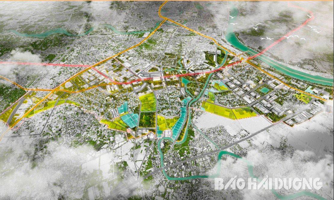
The zoning plan for the southern part of Ring Road I (Vo Van Kiet Avenue, Hai Duong City) has exploited the land fund and advantages of the ring road to promote and create more development poles for the city in the future.
Belt space axis
Ring Road I is a key traffic project of Hai Duong City with a length of about 30 km with 2 bridges over Thai Binh River, intersecting with Provincial Road 390, National Highway 5, Dai An Industrial Park. This ring road surrounds the city, passing through the wards and communes of Thach Khoi, Ai Quoc, Nam Dong, Lien Hong, Gia Xuyen, Ngoc Son, Tien Tien, Quyet Thang, An Thuong. Ring Road I is expected to bring great benefits, actively contributing to increasing the value and expanding the space to attract investment for Hai Duong City. Currently, the city has deployed Ring Road I from Lien Hong commune to Ngoc Son (named Vo Van Kiet Avenue).
According to the orientation of adjusting the general planning of Hai Duong city until 2040, the first ring road is identified as one of the main development spatial axes of the city. On the other hand, with many advantages in location and traffic, the southern area of Hai Duong city with the first ring road passing through will have great potential for exploitation, forming green urban areas, service centers, ecological parks, and high-rise highlights.
.jpg)
The research area for the zoning plan south of Ring Road I is located on the administrative boundaries of wards and communes of Lien Hong, Ngoc Son, Gia Xuyen, Tan Hung, and Thach Khoi with a total area of over 1,050 hectares.
This subdivision borders agricultural land of Tan Hung ward to the north, Gia Loc district to the south, Thai Binh river to the east, and National Highway 37 to the west.
The subdivision is oriented towards green urban development combined with renovation and beautification of old villages. At the same time, it develops public functional areas, cultural parks, green parks, trade services, logistics services, housing and urban utilities... Developing Ngoc Son and Thach Khoi-Gia Xuyen industrial clusters to meet production and business needs. This area is planned as a multi-functional area, meeting the living and working needs of the community. This place is expected to be a new attractive and appealing spot with many convenient segments.
2 functional areas
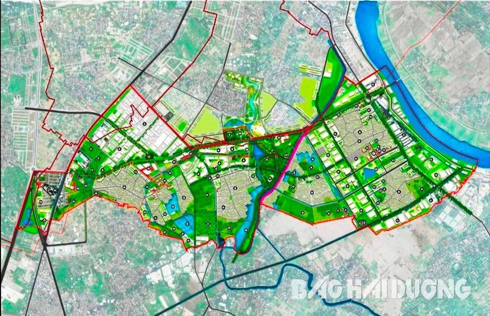
Based on the assessment of potential and strengths, the zoning plan for the south of Ring Road I organizes space, landscape and architecture into 2 functional areas.
Zone 1 is defined as an industrial, service, research and training urban area and an ecological park with an area of about 567 hectares. The planning scope includes the entire administrative boundary of Gia Xuyen commune, part of Thach Khoi and Tan Hung wards and Lien Hong commune. The function of Zone 1 will be new residential development areas closely linked with industrial functions, planned expanded wholesale markets, research and training centers, central ecological parks, and the provincial martyrs' memorial area.
The planning orientation in Zone 1 will inherit and basically maintain the spatial structure of the current residential area, the projects that have been and are being invested in construction. These are the Thach Khoi-Gia Xuyen industrial cluster, the current handicraft point, the new urban area in the south of the city, the central area of the commune...
In addition, research will be conducted to renovate and supplement some planning indicators to suit local development requirements, and connect the current population with the project area being formed.
.jpg)
Zone 1 also plans commercial land funds, medical centers, training research centers, and urban central parks based on the current status factors with local characteristics to increase the value and landscape of the urban area on both sides of Ring Road I. At the same time, maintain some agricultural land funds in the south, orient development towards organic agriculture, high-tech application, combined with the central park to exploit and serve tourism associated with agriculture...
Zone 2 will develop an urban area providing logistics services and developing urban services with an area of 485 hectares, corresponding to the entire administrative boundary of Ngoc Son commune. The function of this area is a newly developed residential area associated with existing villages, a logistics warehouse center. Zone 2 is oriented to plan a commercial, tourism, and logistics service area. Including a green park in the center of Ngoc Son commune and a green strip of water surface to the east of My Xa village to create space, architectural landscape and serve the entertainment needs of the people. New housing groups in the central area of Ngoc Son commune, Pham Xa village, My Xa. In addition, the agricultural land fund in the south and east will continue to be maintained to develop ecological agriculture associated with tourism...
From the orientation of the zoning plan for the southern part of the Ring Road I, scale 1/2000, Hai Duong province has identified priority investment projects here until 2030. That is, to establish detailed planning, implement projects for residential areas, new urban areas, new medical land, commercial services, public services, green parks, culture, research and training according to the zoning plan. Invest in completing the new urban area in the south of the city. Develop a logistics center in the planning area. Invest in building a memorial area for provincial heroes and martyrs, a central park, a cemetery, production and business establishments, other cultural, social and sports institutions... Focus on completing the Ring Road I route, the road connecting to the Gia Loc town bypass, upgrading and expanding provincial road 391 and internal roads.
STRONG.jpg "Thống nhất chủ trương điều chỉnh quy hoạch khu đô thị mới phía nam TP Hải Dương")