


.jpg "What to see in Hai Duong newspaper on April 15?")

.jpg "Podcast News April 14")
.jpg "The Politburo issued Directive 45 replacing Directive 35 on Party Congresses at all levels.")


Submit a comment
For nearly 220 years, through many ups and downs, Thanh Dong (now Hai Duong City) has always had to deal with flood control due to low land levels, many places are always flooded. This problem remains a challenge even today.
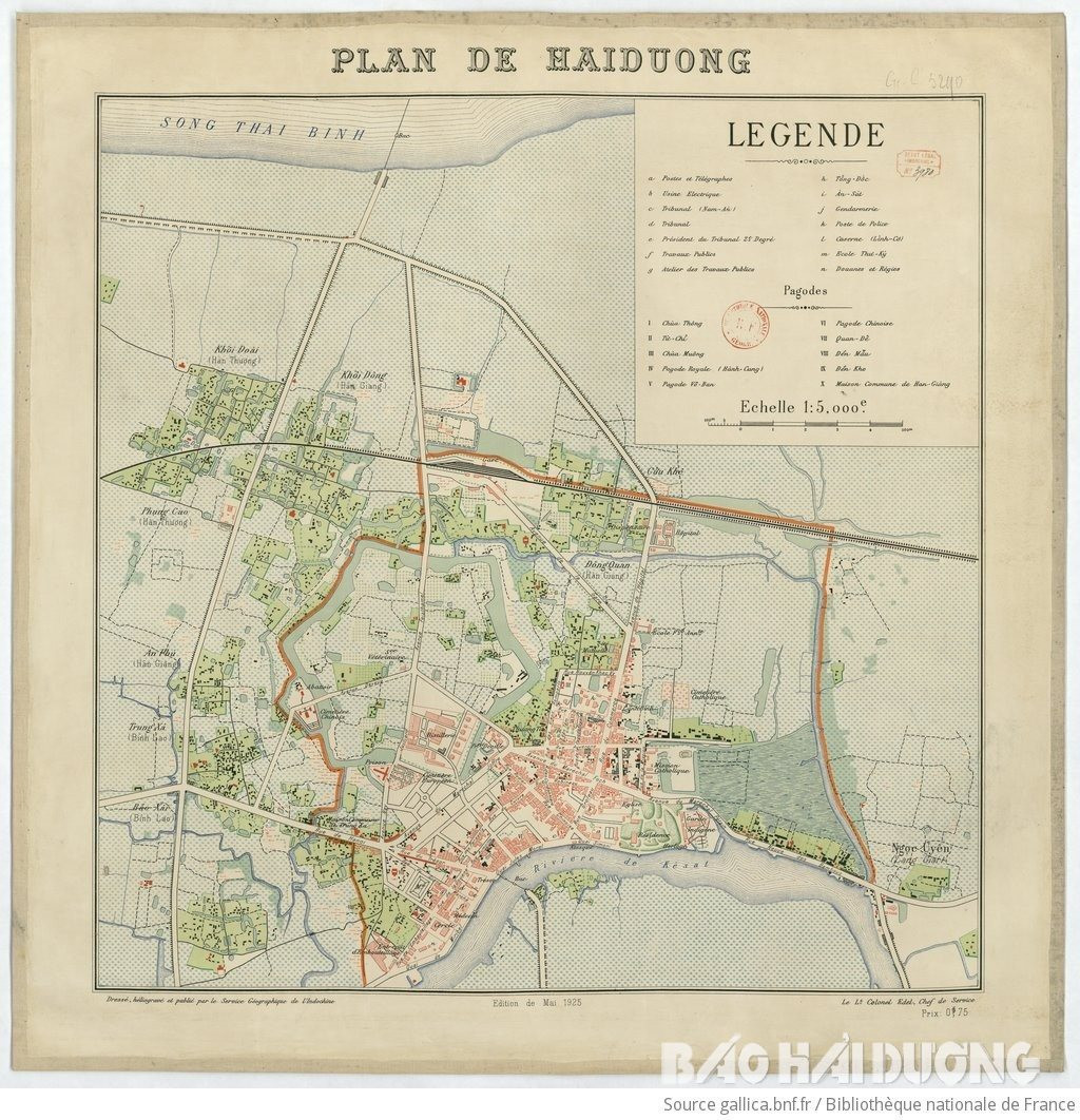
In January of the year of Giap Ty (1804), King Gia Long and Governor Tran Cong Hien laid the foundation for the construction of Dong Thanh.
The citadel is located on high ground, blocking the waterway from the sea to defend the east of Thang Long citadel. This is the type of defensive citadel: "high citadel, deep moat".
Outside the citadel there is a deep moat surrounding it, with a circumference of 582 truong 5 thuoc 4 tac and a width of 7 truong 2 thuoc 5 tac (nearly 30 m). The moat has two functions: defense and drainage, connecting to the Thai Binh River. From 1804 to 1889 the citadel was not flooded. Between 1862 (Nham Tuat) and 1865 (At Suu), the citadel was once besieged for several months by the "Water Bandits" but the soldiers in the citadel still had enough food, water to eat and bathe.
In 1889, the French destroyed the Eastern Citadel and built a winery. The moat was filled in, leaving only two sections in the north and northeast.
In 1923, when expanding Hai Duong urban area in Dong Kieu street, due to low ground level, this place was flooded many times. To prevent flooding, the town built a concrete embankment to prevent water along Sat river, over 1,000 m long, from the beginning of Tam Giang street to near Chai factory. The flood prevention system was equipped with 3 pumps with a total capacity of about 1,000 m3/hour, including one at the beginning of Tam Giang street, one near Chai factory (these two pumps pump water to prevent flooding in the city into Sat river) and one on Nguyen Trai street to pump water into the moat connecting to Binh Minh lake area.
In early 1930, the town government assigned the Wine Factory to use some newly leveled plots of land. This factory invested in building a drainage system with 1,000 mm diameter sewer pipes along the section of National Highway 5 (today) going through the city to De Lao Street (Nguyen Trai Street) connecting to the western moat to drain water to Binh Minh Lake and flow into the Sat River.
Within 15 years (1930-1945), the city's drainage system was only built with a length of about 5 km, including reinforced concrete pipes with diameters of 500 mm to 1,500 mm.
During the great floods of 1939, or the rains that caused flooding from August 15 to 18, 1945, the three pumps were not enough to prevent flooding, and the city was flooded for many days. The demonstration of the revolutionary masses on the afternoon of August 17, 1945 took place in a scene of quite deep flooded streets.
After October 30, 1954, peace was restored, the town's population increased to over 30,000 people. Vocational schools, factories, schools... were expanded, residential land area increased, pond area decreased. 3 small pumps were not enough to prevent flooding. During heavy rains causing long-term flooding, the town government had to mobilize water wheels from neighboring communes to prevent flooding, but it still could not solve the annual flooding problem.
During the great floods of 1968 and 1971, the area at the intersection of Nguyen Van To - Quang Trung streets was flooded over 1m deep. Doc Lap Flower Garden was flooded nearly 1m deep for many days. People traveling in the inner city had to use boats and rafts. In 1972, the town decided to break the concrete embankment, build a dike along the Sat River (now Chuong Duong Street and the dike is now Bui Thi Xuan Street) to the boat port to protect the Phuc Duyen rice field. Built a "4-tap pumping station" (at the beginning of Bui Thi Xuan Street adjacent to today's Bach Dang Street) with a total capacity of 18,000m3/hour. 4 pumps were manufactured by Hai Duong Pump Manufacturing Factory. The dike system was completed in 1973 and the name of the 4-tap pumping station has existed for the past 30 years and has become a familiar name for an area in Hai Duong city.
By the year 2000, the city had formed more residential areas such as Dang Quoc Trinh, Thong Nhat Street, Wood Enterprise and a commercial area that expanded to both sides of Bui Thi Xuan Street. Suburban communes, industrial parks... expanded, the population increased, the 4-tap pumping station also revealed many disadvantages such as: horizontal shaft pumps, difficult management and operation, old and outdated machinery and equipment. The city planning expanded, the pumping station was located in an unsanitary environment. When pumping water from the city, the residential areas of Dang Quoc Trinh and Le Thanh Nghi were flooded, causing serious pollution...
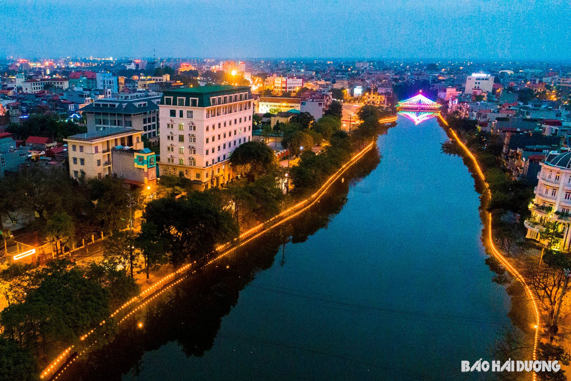
Due to these unreasonable things, the city government decided to abandon the 4-tap pumping station and build a new 5-tap pumping station near the bank of Thai Binh River in Ngoc Uyen village with a total capacity of 40,000 m3/hour. The new pumping station has a modern vertical pump, automatic operation and control. The city also dug a drainage canal with solid concrete on both the bottom and both sides of the canal, 1 km long, 3.5 m deep, 13 m wide to lead water from Sat River to the pumping station. The project was completed in 2003 and is a major investment project of the city. The 5-tap pumping station has contributed to basically overcoming the situation of flooding for many hours in the city.
In recent years, the amount of wastewater of all kinds in the city has increased dramatically. Of which, domestic wastewater is over 50,000m3/day and night; industrial wastewater is over 3,000m3/day and night, causing increasingly serious pollution. Since 2008, the city has continuously invested in and upgraded the drainage system. Central streets such as Pham Ngu Lao, Tuy Hoa, Ngan Son, Bac Son, Quang Trung, Dong Thi intersection... due to low ground level, when there is heavy rain, they are often flooded for many hours, but now they drain faster.
In 2008, the city's administrative boundaries were expanded, increasing the area to 71.4 km2. The transportation system developed rapidly, but the drainage system on the roads could not keep up, and every time there was heavy rain, there was prolonged flooding. The main reason was that these areas had large flat areas, low ground levels, and an unsynchronized drainage system, so water could not drain naturally and had to be pumped through drainage pumping stations, so the water drained slowly.
In 2019, the city became a class I urban area, merging a number of communes from neighboring localities, increasing the city to 17 wards, 9 communes, and the area to 111.22 km2. The newly merged communes have a relatively reasonable system of pumps and irrigation canals and a relatively reasonable system of regulating ponds. However, due to the impact of storm No. 3, on August 26, 2022, heavy rain for many hours caused widespread flooding in the old inner city and residential areas in Thanh Binh, Tu Minh, Ngoc Chau, Binh Han wards... The main cause is still the asynchronous drainage system, not strong enough to drain quickly and promptly.
In 2022, the city allowed Ngoc Chau ward to renovate the drainage system south of Highway 5, installing a large sewer system 1.8 m high and 2 m wide, but the inner city still has many areas with low ground levels such as along the route from Tu Minh, Thanh Binh... or low slopes, so drainage is still difficult. Old streets such as Quang Trung, Bac Son, Nguyen Van To... have not been renovated or upgraded for a long time, so they are still at the lowest level in the city...
Every time there is a heavy rain, many streets and alleys are still flooded, although some places last for a long time, some places quickly. That shows that, nearly 220 years after its establishment, Thanh Dong still has to persevere in "water control". The problem of ending flooding after heavy rains lasting for many hours in the condition that many ponds and lakes have been filled in is always a challenge for the Hai Duong City government.
The expansion of urban space has led to shortcomings in technical infrastructure connections, especially drainage and flood prevention systems. The western area of Hai Duong City and the northern part of the railway are the "flooding center" of the city. To solve this situation, Hai Duong City has implemented many flood prevention projects and works. A typical example is the Dynamic Urban Development Project with 9 packages. This project, when completed and put into use, will contribute to limiting flooding during heavy rains in the western part of the city. Although only 2 packages have been completed, after some recent heavy rains, the areas of Nguyen Luong Bang, Nguyen Thi Due, Nguyen Quy Tan, Vu Huu streets... no longer have prolonged flooding.
PHAM QUY MUI
.jpg "Guidance on developing personnel plans for provincial and communal Party committees in the context of consolidation and merger")


.jpg "Exhibition of cooperation documents between Vietnam and China")

.jpg "Hai Duong voters propose many contents on the proposed province merger and the arrangement of commune-level administrative units.")

