


.jpg "Outstanding domestic and international events on April 15")

.jpg "Close-up of the car carrying General Secretary and President Xi Jinping in Hanoi")


Submit a comment
Storm No. 3 has strengthened to level 16, gusting over level 17, becoming a super storm in the East Sea; at the same time, it is the strongest storm in the world in 2024 up to this point.
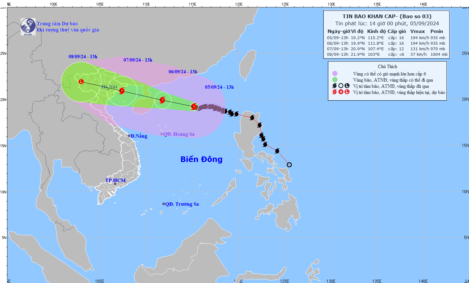
According to the National Center for Hydro-Meteorological Forecasting, at 1:00 p.m. on September 5, the center of the super typhoon was located at about 19.2 degrees North latitude; 115.2 degrees East longitude, in the northern sea area of the North East Sea, about 460 km east of Hainan Island (China). The strongest wind near the center of the super typhoon was level 16 (184 - 201 km/h), gusting to level 17, moving westward at a speed of about 10 km/h.
Forecast, by 13:00 on September 6, the storm will move in the West Northwest direction, speed 10 - 15km/h, storm location at 19.9N-111.8E; in the sea northeast of Hainan Island (China), about 510km east southeast of Quang Ninh, storm intensity level 16, gusts above level 17, dangerous area North latitude 16.0N; longitude 109.0E - 118.5E, natural disaster risk level 4, affected area north of the North East Sea.
At 1:00 p.m. on September 7, storm No. 3 moved in the West-Northwest direction, about 20km/h and gradually weakened, the storm's location was at 20.9N-107.4E; in the coastal waters from Quang Ninh to Nam Dinh, the storm intensity was level 12, gusting to level 15, the dangerous area was north of latitude 16.0N; west of longitude 114.5E, the disaster risk level was Level 4 in the East of the Northern Gulf of Tonkin, Level 3 in the West of the Northern Gulf of Tonkin and the Southern Gulf of Tonkin.
At 1:00 p.m. on September 8, the storm moved in the West-Northwest direction, about 20 km/h and gradually weakened into a low pressure area, the storm's location was at 21.9N-103.0E; in the Northwest region, the storm intensity was below level 6, the dangerous area was north of latitude 17.0N; west of longitude 112.0E, the natural disaster risk level was level 3, the affected area was the Gulf of Tonkin.
On land, from early morning on September 7, coastal areas from Quang Ninh to Thanh Hoa will have winds gradually increasing to level 6 - 7, then increasing to level 8 - 9, areas near the storm center will have winds of level 10 - 12, gusting to level 14; areas deep inland in the Northeast will have strong winds of level 6 - 8, gusting to level 9 - 11.
Coastal areas from Thanh Hoa to Quang Ninh need to be on guard against storm surges of 0.5 (Thanh Hoa) - 1.8 m (Quang Ninh) in the afternoon and night of September 7 and storm recedes of 0.5 (Thanh Hoa) - 1.0 m (Quang Ninh) in the morning of September 7.
Boat mooring areas, aquaculture areas, dykes and seawalls in the above-mentioned dangerous areas are all likely to be affected by strong winds, large waves and storm surges/ebb.
Experts warn that from the night of September 6 to the morning of September 9, the Northern and North Central regions may experience heavy rain, some places may have very heavy rain and thunderstorms with total rainfall ranging from 100-350 mm, some places over 500 mm. Heavy rain is likely to cause flooding in low-lying areas; flash floods on small rivers and streams, landslides on steep slopes.
Due to the influence of the wide storm circulation, it is necessary to be on guard against the risk of thunderstorms, tornadoes and strong gusts of wind both before and during the storm's landfall.
Due to the impact of the storm, the North East Sea area has strong winds of level 11-14, the area near the center of the super storm has winds of level 15-16, gusting over level 17; the sea is very rough.
From around noon on September 6, the eastern sea area of Bac Bo Gulf (including Bach Long Vy island district) has winds gradually increasing to level 6 - 7. From the night of September 6, the Bac Bo Gulf area (including Bach Long Vy island district, Co To) has winds gradually increasing to level 8 - 9, then increasing to level 10 - 12, the area near the storm's center has winds of level 13 - 14, gusting to level 17; the sea is very rough.
The North East Sea has waves 7-9m high, near the center of the super typhoon 10-12m. The sea is very rough.
From noon on September 6, in the Gulf of Tonkin (including Bach Long Vi and Co To island districts), waves were 2-4m high, then increased to 3-5m, and 6-8m high near the storm's eye.
From early morning on September 7, coastal waters from Quang Ninh to Thanh Hoa had waves 2-3 m high, later increasing to 2-4 m, and 3-5 m near the storm center.


.jpg "General Secretary To Lam: Economic development and improving people's quality of life are top priorities")
