


.jpg "Bão số 7 chưa qua, bão Toraji lại sắp 'nối gót' vào Biển Đông")


.jpg "Outstanding domestic and international events on April 15")

.jpg "Close-up of the car carrying General Secretary and President Xi Jinping in Hanoi")


Submit a comment
Typhoon Toraji has entered the eastern sea of the North East Sea, becoming the eighth typhoon of 2024. The storm is forecast to weaken rapidly and dissipate at sea.
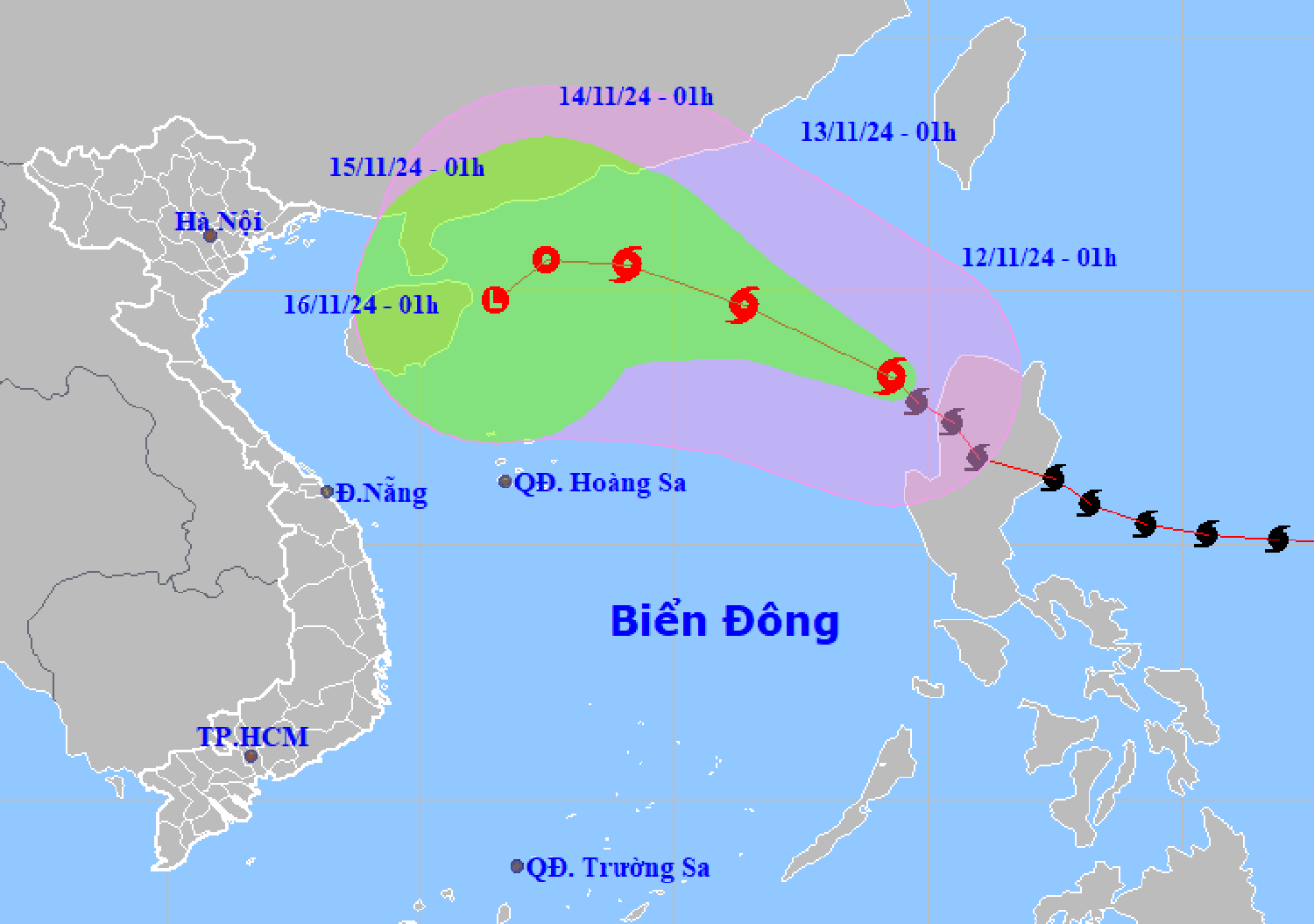
According to the National Center for Hydro-Meteorological Forecasting, at 1:00 a.m. on November 12, the center of storm No. 8 was located at about 18.3 degrees north latitude, 119.3 degrees east longitude, in the eastern sea of the North East Sea. The strongest wind near the center of the storm is level 10-11 (89-117 km/h), gusting to level 13. Moving northwest, speed about 20 km/h.
It is forecasted that in the next 24 hours, storm No. 8 will maintain its direction of movement, at a speed of 15-20km/h. At 1:00 a.m. on November 13, the center of the storm will be located in the eastern sea area of the North East Sea, with a level 10 intensity, gusting to level 12.
The storm then changed direction to move west-northwest at a speed of 10-15km/h, gradually weakening in intensity. At 1:00 a.m. on November 14, the storm center was located in the northern sea area of the North East Sea, with intensity decreasing to level 8-9, gusting to level 11.
In the following hours, the storm moved northward into the North East Sea at a speed of about 10km/h and gradually weakened into a tropical depression.
From the next 72-96 hours, the tropical depression will move west-southwest, about 5km per hour, and continue to weaken.
Thus, storm number 8 after entering the East Sea tends to weaken quickly and dissipate at sea.
However, due to the influence of the storm, the sea area east of the North East Sea has strong winds of level 6-7, then increasing to level 8, the area near the storm's eye has levels 9-11, gusts of level 12, waves 3-5m high, the area near the storm's eye has 5-7m, very rough seas.
Ships operating in the above mentioned dangerous areas are likely to be affected by storms, whirlwinds, strong winds and large waves.
Meanwhile, storm No. 7 has weakened into a tropical depression. At 1:00 a.m. on November 12, the center of the tropical depression was at about 15.3 degrees north latitude, 109.9 degrees east longitude, over the sea of Quang Nam-Binh Dinh provinces. The strongest wind near the center of the tropical depression is level 6, gusting to level 8. Moving southwest at a speed of 15-20 km/h.
In addition, meteorological experts say the East Sea may welcome storm No. 9 in the near future, as off the coast of the Philippines there is a tropical depression and a distant storm active.
VN


.jpg "General Secretary To Lam: Economic development and improving people's quality of life are top priorities")
