


.jpg "Hai Duong took 33 samples of medicine, milk and functional foods for quality testing.")
.jpg "Be cautious about 'surfing' real estate before merging Hai Duong and Hai Phong")


.jpg "Thai Tan village (Nam Sach) is green from house to alley")


.jpg "Number of newly established enterprises in Hai Duong increased by 21.3%")


Submit a comment
Storm No. 7 is forecast to turn southwest, slowly moving towards the Hoang Sa archipelago, then to coastal waters from Quang Tri to Quang Ngai provinces.
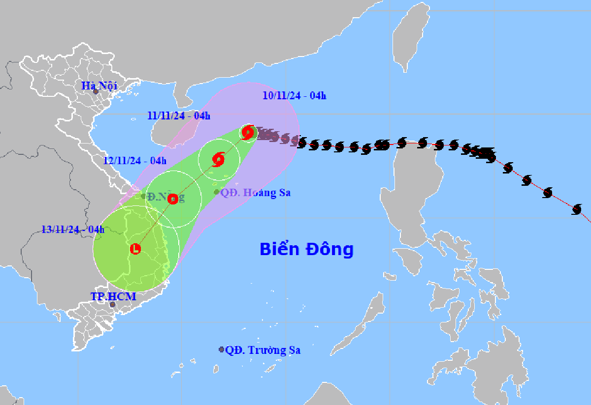
According to the National Center for Hydro-Meteorological Forecasting, at 4:00 a.m. on November 10, the center of storm No. 7 was located at about 19.1 degrees north latitude, 113.2 degrees east longitude, in the northwest sea of the North East Sea, about 335km north-northeast of the Hoang Sa archipelago. The strongest wind near the center of the storm is level 14 (150-166km/h), gusting to level 17. Moving westward, at a speed of about 5km/h.
It is forecasted that in the next 24 hours, storm No. 7 will change direction to the southwest at a speed of 5-10km/h and gradually weaken. At 4:00 a.m. on November 11, the storm's center will be 145km north of Hoang Sa archipelago. The strongest wind near the storm's center is level 10, gusting to level 13.
At around 4:00 a.m. on November 12, the storm from the sea of Quang Tri to Quang Ngai continued to move southwest at a speed of 10-15 km/h, gradually weakening into a tropical depression.
At 4:00 a.m. on November 13, the tropical depression in the Central Highlands region, moving southwest at a speed of 10-15 km/h, weakened into a low pressure area.
Due to the influence of the storm, the sea area west of the North East Sea has strong winds of level 7-10, the area near the storm's eye has winds of level 11-14, gusts of level 17, waves 4-6m high, the area near the storm's eye has waves of 7-9m, and the sea is very rough.
Ships operating in the above mentioned dangerous areas are likely to be affected by storms, whirlwinds, strong winds and large waves.
VN
