


-ac017d3d3ce25d3405471795d6bb26f0.jpg "Gia Loc needs over 10 billion VND to invest in renovating and expanding landfills.")

.jpg "Extremely dangerous forest fire risk in Kinh Mon, Chi Linh")

.jpg "Hai Duong City solves the 'problem' of construction waste dumping sites")
.jpg "The North begins a series of hot days")
.jpg "Real estate market in the south of Hai Duong city is bustling")


Submit a comment
Typhoon Man-yi has entered the East Sea, becoming storm number 9. The storm is gusting at level 15 and moving very quickly towards the Central Central provinces.
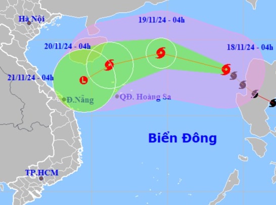
At 4:00 a.m. this morning, November 18, the center of storm No. 9 (storm Man-yi) was at about 18.0 degrees north latitude; 118.9 degrees east longitude, in the eastern sea of the North East Sea. The strongest wind near the center of the storm was level 11-12, gusting to level 15. The storm moved northwest at a speed of about 25 km/hour.
At 4:00 a.m. on November 19, the storm moved in a West-Northwest direction at a speed of about 20 km/h, continuing to weaken further in the North East Sea; about 370 km northeast of Hoang Sa archipelago with winds of level 10, gusts of level 12.
At 4:00 a.m. on November 20, the storm moved in a West-Southwest direction at about 15 km/h, continuing to weaken further in the western area of the North East Sea; about 210 km northwest of Hoang Sa archipelago with winds of level 8, gusting to level 10.
At 4:00 a.m. on November 21, the storm moved southwest at a speed of about 10 km/h, gradually weakening into a tropical depression, then a low pressure area in the sea off the Central Central Coast with wind force level 6.
The eastern sea area of the North East Sea has strong winds of level 8-9, near the eye of the storm level 10-12, gusting to level 15, waves 3-5 m high, near the eye of the storm 5-7 m; rough seas. Ships operating in the above-mentioned dangerous areas are likely to be affected by storms, whirlwinds, strong winds, and large waves.
In the Gulf of Tonkin, the sea area from Quang Tri to Quang Ngai has Northeast wind level 6, gusting to level 7-8; waves 2-5 m high; rough sea.
PV (synthesis)