


.jpg "Real estate market in the south of Hai Duong city is bustling")

.jpg "Extremely dangerous forest fire risk in Kinh Mon, Chi Linh")


-ac017d3d3ce25d3405471795d6bb26f0.jpg "Gia Loc needs over 10 billion VND to invest in renovating and expanding landfills.")


Submit a comment
The Ministry of Agriculture and Rural Development has just sent a telegram to respond to storm Man-yi, which is forecast to enter the East Sea tomorrow with a level 12 intensity and gusts of level 14.
On November 17, the Ministry of Agriculture and Rural Development sent a document to a number of ministries, branches and People's Committees of coastal provinces from Quang Ninh to Binh Thuan on responding to storm Man-yi.
Super typhoon Man-yi is active in the sea east of the central Philippines, forecast to enter the East Sea on November 18 with a force of level 12, gusting to level 14.
To proactively respond, the Minister of Agriculture and Rural Development requested ministries, branches, and coastal provinces from Quang Ninh to Binh Thuan to closely monitor the storm's developments; manage means of transport going out to sea; organize the counting of ships and boats; notify owners of means of transport, captains of ships and boats in operation about the location, direction of movement, and developments of the storm so that they can proactively avoid, escape, or not move into dangerous areas.
The Ministry of Agriculture and Rural Development requires ministries, branches and People's Committees of the above coastal provinces and cities to prepare forces and means for rescue.
The Ministry of Agriculture and Rural Development requested the Voice of Vietnam, Vietnam Television, Vietnam News Agency, coastal information stations and mass media agencies from central to local levels to strengthen measures to inform about the storm's developments to authorities at all levels and people in order to proactively prevent and respond promptly and effectively.
Ministries and branches, according to their functions, state management tasks and assigned tasks, proactively direct and coordinate with localities to respond to storm developments; strictly maintain 24/7 duty, regularly report to the Ministry of Agriculture and Rural Development through the Department of Dyke Management and Natural Disaster Prevention.
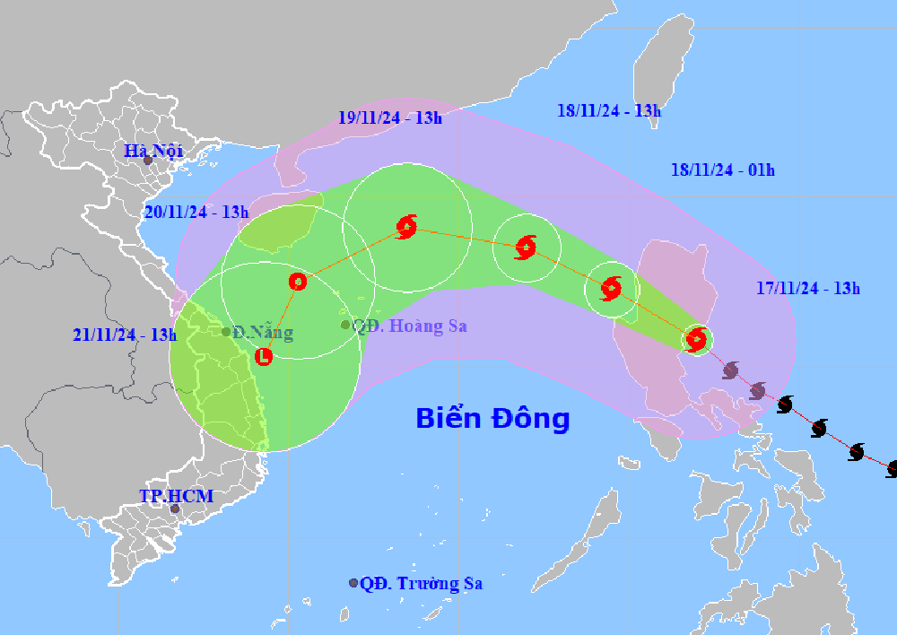
According to the National Center for Hydro-Meteorological Forecasting, at 1:00 p.m. on November 17, the center of super typhoon Man-yi was at about 15.8 degrees north latitude; 122 degrees east longitude, on the southeastern coastal area of Luzon Island (Philippines). The strongest wind near the center of the super typhoon was level 16 (184-201 km/h), gusting to level 17. Moving northwest at a speed of 20 km/h.
It is forecasted that in the next 24 hours, super typhoon Man-yi will move northwest at a speed of about 25km/h, enter the East Sea and gradually weaken. At 1pm on November 18, the center of the storm was located in the eastern sea area of the North East Sea, about 640km east-northeast of the Hoang Sa archipelago. The strongest wind near the center of the storm is level 11-12, gusting to level 14.
At 1 p.m. on November 20, the storm changed direction, moving southwest and weakening into a tropical depression in the sea northwest of Hoang Sa archipelago.
According to Mr. Nguyen Van Huong, Head of the Weather Forecast Department (National Center for Hydro-Meteorological Forecasting), the time when storm Man-yi moves into the East Sea is also the time when the East Sea is affected by a strong cold air mass. The interaction of cold air and storm Man-yi will cause many changes in the intensity and direction of storm Man-yi.
The most important thing to note is that the interaction of cold air and storm Man-yi will make the weather in the East Sea very bad in the coming days, with strong winds, high waves and rough seas. The development of this storm is still changing, so we need to monitor it closely.
VN (synthesis)