


.jpg "Bão số 8 suy yếu, khả năng cao xuất hiện bão số 9 đầu tuần tới")
.jpg "11 big problems in science, technology, innovation and digital transformation of Hai Duong")


.jpeg "Difficult things should not be done carelessly.")


.jpg "Hai Duong traffic focus on May 10")


Submit a comment
Typhoon Man-yi is moving west-northwest. The strongest winds near the storm's center are at level 15, gusting to level 17, and are likely to make landfall in the East Sea early next week.
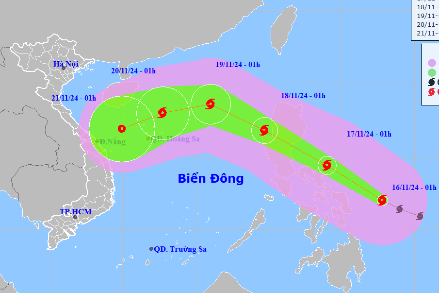
According to the National Center for Hydro-Meteorological Forecasting, at 1:00 a.m. this morning, November 16, the center of storm Man-yi was in the sea east of the central Philippines.
The storm is moving in a West Northwest direction at a speed of 20-25km/h. The strongest wind near the storm center is level 15, gusting to level 17.
It is forecasted that by November 18, the storm will enter the East Sea, with the strongest winds near the storm's center reaching level 12-13, gusting to level 16.
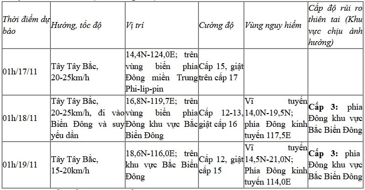
From the next 72 to 120 hours, the storm moved in the West Southwest direction, about 15km per hour, and continued to weaken.
Due to the impact of the storm, from the afternoon of November 17, the eastern sea area of the North East Sea had strong winds of level 6-7, then increased to level 8-10, the area near the storm's eye had winds of level 11-13, gusting to level 16, waves 2-4m high, the area near the storm's eye had waves of 5-7m; the sea was very rough.
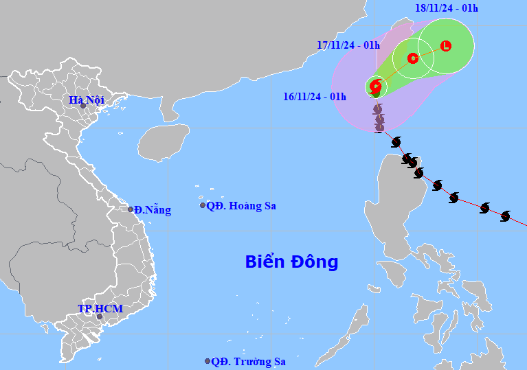
Meanwhile, storm Usagi has not been recorded as storm number 9 because it is moving along the 120th meridian. At 1:00 a.m. this morning, the center of the storm was at about 22 degrees North latitude, 120.1 degrees East longitude, in the sea south of Taiwan (China).
The storm is moving north at a speed of about 15km/h. The strongest wind near the storm center is level 8-9, gusting to level 11.
It is forecasted that in the next 24 to 72 hours, the storm will move northeast, then turn east northeast, over the sea east of Taiwan and gradually weaken into a low pressure area.
.jpg "Bão Usagi giật cấp 12 đổ bộ Biển Đông, trở thành cơn bão số 9")


.jpg "Hai Duong completed the target of each locality building 15 new houses for policy families, poor and near-poor households.")