


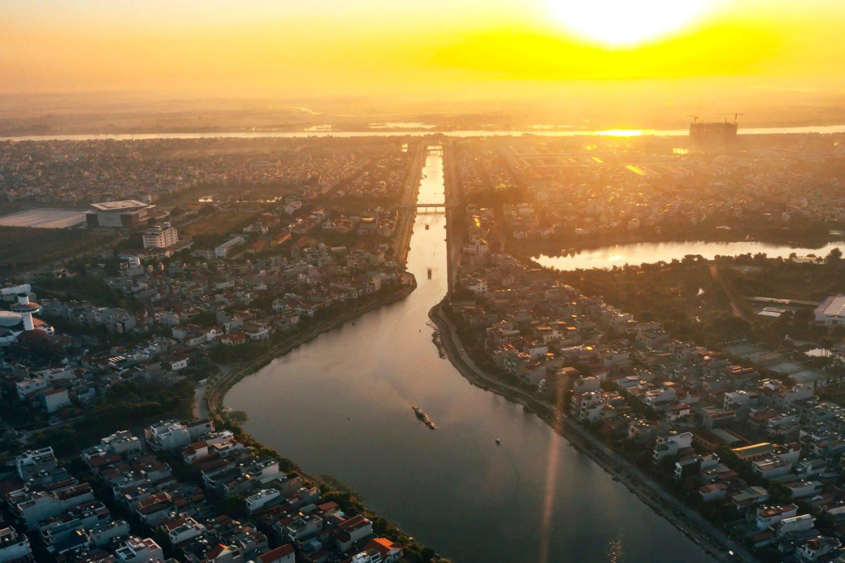
.jpg "Real estate market in the south of Hai Duong city is bustling")

.jpg "Extremely dangerous forest fire risk in Kinh Mon, Chi Linh")


-ac017d3d3ce25d3405471795d6bb26f0.jpg "Gia Loc needs over 10 billion VND to invest in renovating and expanding landfills.")


Submit a comment
Old maps can show us the appearance of Thanh Dong, Hai Duong City, after 220 years of development.
In the beginning
Hai Duong City has undergone 220 years of development since the Hai Duong town office moved from Mao Dien (Cam Giang) to the central urban location, the heart of the province today.
Which map depicts the space of Thanh Dong in the early days? In search of an answer to my question, many people pointed me to the “living history” of Thanh Dong - Mr. Pham Quy Mui, former Director of the Hai Duong City Political Training Center. He is also called by many people as the historian of Thanh Dong.
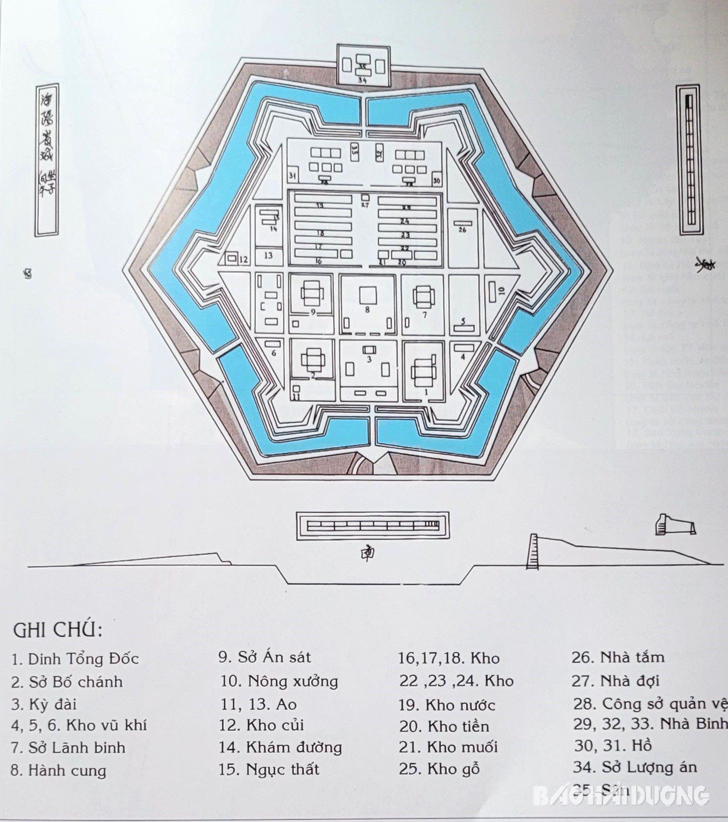
Opening the book History of Hai Duong town edited by him exactly 30 years ago, Mr. Mui introduced us to the map of Thanh Dong in 1804. According to Mr. Mui, this can be considered the first map that clearly shows the birth and formation of Thanh Dong in the beginning. The map of Thanh Dong in 1804 has a regular hexagon shape. The center of Thanh Dong at that time was determined to be the area of the former Mill (now Hoang Hoa Tham street). The map clearly shows that Thanh Dong has a perimeter of about 551 truong (ancient measurement unit), equivalent to 2,204 m today. The citadel is 1 truong, 1 thuoc, 2 tac high (about 4.48 m) with a total area of about 35 hectares.
Explaining why the East Citadel map in 1804 had a hexagonal shape, according to Mr. Mui, this was the design of French engineer VauBan, a popular and very effective defensive citadel in Europe in the 17th and 13th centuries. This was also a unique feature of the East Citadel compared to many other places in the country at the same time.
The diagram, though simple, clearly depicts the shape of the ancient Dong Citadel with a hexagonal inner citadel space surrounded by a deep moat. The moat connects to the Ke Sat River and the Han Giang River (now the Thai Binh River). This is the route for supplying food and weapons to the army in the citadel. The inner citadel connects to the outside through 4 gates: east, west, south, north. From inside the citadel, to go outside, one must cross 4 brick bridges built in an arched style across the moat.
According to Mr. Mui, through the diagram, it can be seen that Thanh Dong was initially just an administrative and military center. This is clearly shown in the 35 items noted on the diagram, including the Governor's Palace, the Department of Public Affairs, the Military Command Department, and many warehouses of weapons, food, money, salt, and even a prison area... According to recorded documents, at that time, the citadel had about 3 military bases with about 1,000 people including officials and soldiers, and no residents yet.
Considered the eastern fence of Thang Long Citadel, for nearly a century, the Nguyen Dynasty continuously consolidated Thanh Dong into a strong military fortress. Later, Thanh Dong had the appearance of Dong Kieu quarter. This was the area where small traders and craftsmen gathered. They gathered near Thanh Dong area to do business, trade, and produce products to serve the needs of mandarins and soldiers in the citadel. Gradually, a crowded residential area was formed right next to Thanh Dong. Dong Kieu quarter was shown on the map of Hai Duong city in 1923.
Constantly expanding and developing
An expanded and urbanized Eastern Citadel gradually took shape under French rule.
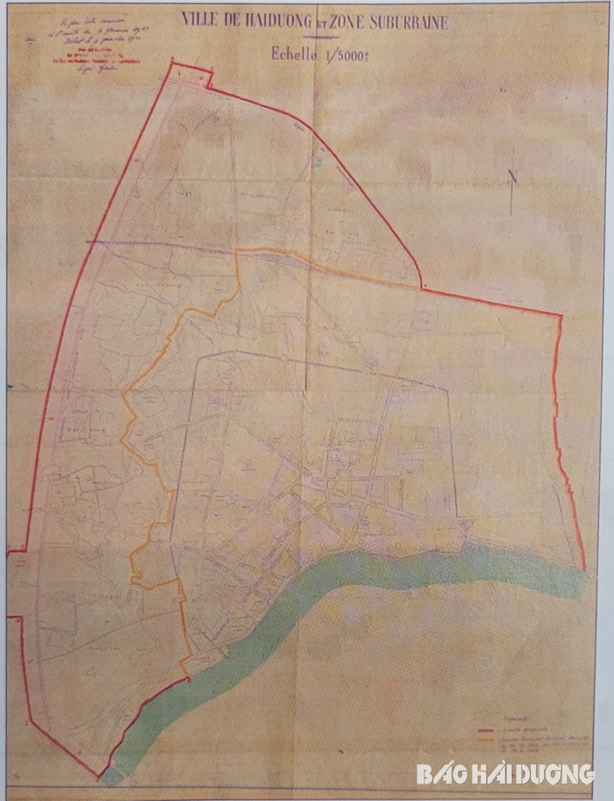
On August 19, 1883, the French army occupied Thanh Dong. On November 24, 1884, Consul Omoáto signed the first document on police and urban traffic, but the urban space of Thanh Dong at that time was not yet specifically determined. Nine years after occupying Thanh Dong, on November 8, 1892, Governor-General of Indochina De Lanessan signed a decree stipulating that the urban area included the entire ancient citadel, Dong Kieu Pho area and some rural areas around Thai Binh River and Ke Sat River. This was the first administrative boundary and also the time when the urban boundary of Hai Duong was specifically determined on the map of Hai Duong City in 1923. On this map, Hai Duong City was completely separated from the boundary of Cam Giang town (now Cam Giang district). This was the basis for Governor-General of Indochina M. Merlin to issue a decree establishing Hai Duong City on December 12, 1923. The establishment of Hai Duong city opened up development opportunities for Hai Duong urban area at that time.
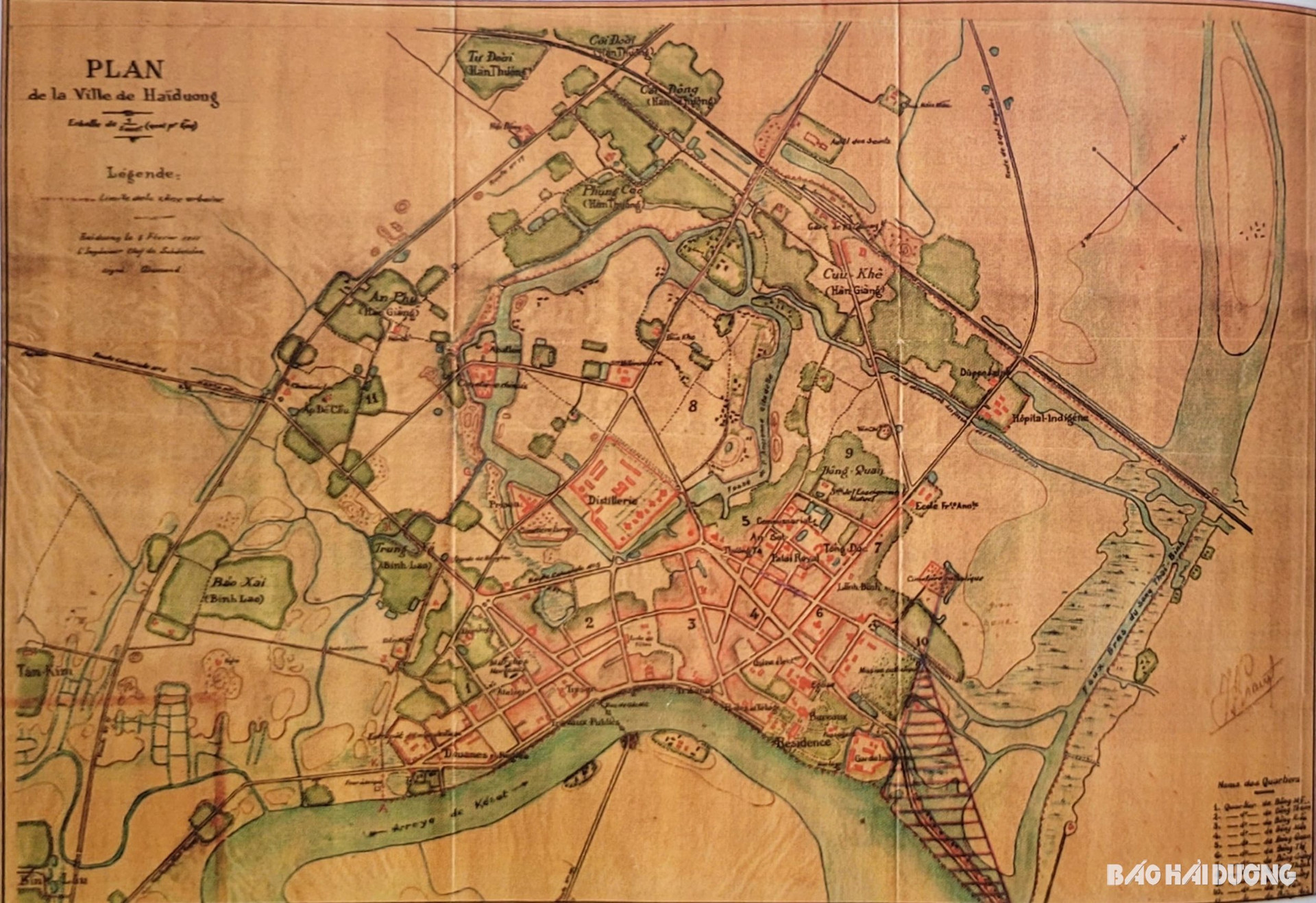
According to the 1923 map of Hai Duong City, the city was divided into 11 areas including: Dong My, Dong Thuan, Dong Kieu, Dong Mon, Dong Quan, Dong Thi, Dong Giang, Dong Hoa, Cuu Thanh, Han Giang and Tu Tan. According to the book History of Hai Duong Town published in 1994, after the establishment of Hai Duong City, urban construction and planning activities were of special interest to the contemporary government. Land surveying was carried out urgently to serve the city planning work. The 1923 map shows that the scale of Hai Duong City was constantly expanding. At this time, Hai Duong City had more than 6,000 people, 6 times larger than the administrative and military center in 1804. After planning, new residential areas around Hai Duong station and the winery were formed. Roads were built more spaciously. Around the city, river ports are also formed with a developed river transport network connecting the provincial capital with many neighboring localities.
Through the 1923 map, it can be seen that the ancient urban structure of Thanh Dong was initially destroyed and gradually replaced by a French-style urban space with a series of new architectural works. The administrative, military, economic and cultural areas were planned separately.
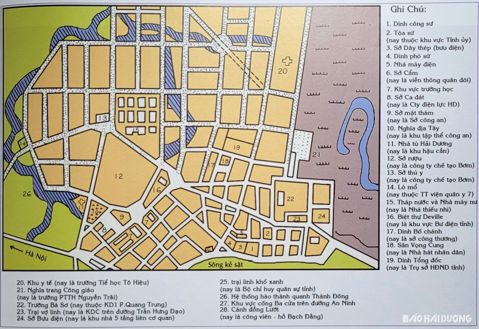
Within 5 years, from 1923 to 1927, the overall project of Hai Duong city was approved and had a clear expansion plan. On the map of Hai Duong city in 1927 and the expansion plan, the entire city area was divided into square plots of land to build industrial, commercial and residential facilities. Many new buildings were built such as: Pho Su Palace, Accounting Department, Agricultural Bank, Land Registration Department, Water Plant, Veterinary Department, new Han Giang market, etc.
According to the records in the book Hai Duong City Gazetteer, volume 1, published in 2013, during this period, Hai Duong City was not only expanded, planned neatly and scientifically, but many streets were also invested in upgrading and becoming more spacious. At the end of 1927, the streets of Khach, Hang Giay, Minh Khai, Hang Bac, and Bac Son were raised 30 cm higher. The city's population increased to 10,000 people.
The period of French rule and occupation laid the first foundations for the formation of Hai Duong urban area. During this time, the protectorate government expanded the urban space of the city three times in 1927, 1929 and 1943. The city's appearance is also shown on the maps that are still preserved in the corresponding years.
Notably, through the planning and expansion map of Hai Duong City in 1943, it can be seen that Hai Duong urban space was expanded to the west and northwest after the Governor General of Indochina issued a decree on expanding the boundaries of Hai Duong City on January 9, 1943. This was also the last expansion of Hai Duong City's boundaries under the French colonial period. The urban space planned, built and formed during this time was also the foundation for creating the appearance of Hai Duong City today.
According to Mr. Pham Quy Mui, after 220 years of development, Thanh Dong in the past, Hai Duong today has many valuable maps, but the most notable are the original map in 1804, then the Hai Duong City map in 1923 marking the birth of Hai Duong City and the map in 1927 was the first time Hai Duong City expanded its urban space, orienting the city's future development.
"2024 marks the 220th anniversary of Thanh Dong's founding, which is also the time for us to look back at the city's appearance over hundreds of years. I really hope that on the occasion of the 220th anniversary of Thanh Dong's founding and the 70th anniversary of the city's liberation, maps of Hai Duong's urban development from the beginning to the present will be displayed and introduced to the public," Mr. Mui said.
Going back in history to learn about the development of Hai Duong City through old maps is very meaningful. This is an opportunity for every citizen of the city to look back to the past and look forward to the future with the aspiration of a new spring of outstanding development. The dynamic and aspirational Hai Duong City will soon realize its goal of becoming an industrial and commercial city by 2030; a healthy city; a creative city; a beautiful and friendly city; a safe and secure city...
BAO ANH