


.jpg "Dấu tích cầu đá cổ ở Xạ Sơn")

![[Audio] Chùa Minh Khánh - nơi lưu dấu tích phật hoàng Trần Nhân Tông](https://bhd.1cdn.vn/thumbs/540x360/2023/07/22/files-library-newimages-cokinhchuaminhkhanh_1_1.jpg "[Audio] Chùa Minh Khánh - nơi lưu dấu tích phật hoàng Trần Nhân Tông")

-a9f705f0fc2bb442b889e7ca8cfb4e9f.jpg "Prime Minister directs early payment of pensions in May")
.jpg "Hai Duong Women Journalists Club organizes the program")
.jpg "Fire in central Hanoi building")


.jpg "Abandoned newborn baby boy in Kim Thanh is temporarily given to a family to care for")
.jpg "Reading culture in the digital age")


.jpg "What to see in Hai Duong newspaper on April 21?")


.jpg "Parishioners joyfully celebrate Easter at Hai Duong Church")


Submit a comment
The ancient Dong Citadel was massive and sturdy. Through the ups and downs of history, the majestic citadel was destroyed, and later generations could only learn about it through the remaining ruins.
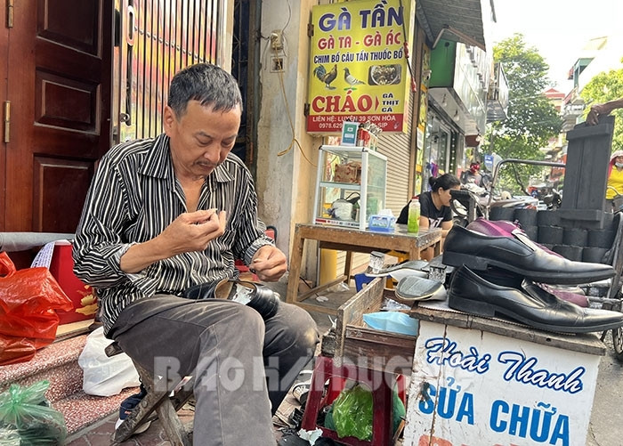
Besides Thang Long citadel, only Thanh Dong has streets named “Hang”. In the photo: Mr. Duong Hoai Thanh’s family on Son Hoa street (old Hang Giay street) has been involved in shoe repair for over 30 years.
Historical Mark
According to historical records, before 1804, the Hai Duong citadel was located in Lac Thien (Chi Linh), at that time called Van citadel or Van camp, then moved to Mao Dien (Cam Giang). In 1804, King Gia Long decided to move the Hai Duong citadel from Mao Dien 15 km east, at the confluence of Ke Sat and Thai Binh rivers, in the area of three communes Han Giang, Han Thuong and Binh Lao. The Hai Duong governor at that time, Tran Cong Hien, was assigned the task of organizing the move and building Hai Duong citadel, also known as Dong citadel. Due to its important strategic location, blocking enemy troops from the sea, during nearly a century of rule, the Nguyen Dynasty continuously consolidated Dong citadel into a strong military fortress.
Like the citadels built during the Nguyen Dynasty, the Eastern Citadel was built in the Vauban style (a method of building solid ramparts by French architects applied in some Western countries and colonies in the 17th-18th centuries). The citadel has a regular hexagonal shape, initially built with earth, and was reinforced with laterite during the reign of King Minh Mang. The citadel is 1 truong 1 thuoc 2 tac (4.48 m) high, and is surrounded by a deep moat outside. The moat connects to the Ke Sat River and then to the Thai Binh River through the Ba Cua sluice, traces of which can still be seen on An Ninh Street. The citadel has 4 gates in the 4 directions of east, west, south, and north. From the Eastern Citadel, to go out, one must cross 4 arched brick bridges spanning the moat. In 1883, the Eastern Citadel fell into the hands of the French colonialists, and by the early 20th century it was almost completely destroyed. Thanh Dong land is located entirely within the area of Nguyen Trai ward today and the vestiges of this citadel are only faintly visible through a few works and limited historical documents.
As a person who has devoted much time to researching the history of Thanh Dong, historian Pham Quy Mui expressed: “The image of a solid Thanh Dong gradually faded away over time, but from this fortress, a bustling economic, political, cultural and commercial center gradually formed. And to this day, on the foundation of the ancient Thanh Dong, a dynamic and strongly developing urban area gradually appeared.”
Preserving old values
At first, Thanh Dong was only a military and administrative center, with only military officers and soldiers in the city, no residents. Gradually, due to the needs of life, the families of military officers, soldiers, craftsmen, businessmen and traders gathered outside the city along the Ke Sat River. From here, Dong Kieu Street was born, forming streets named after guilds and professions, creating favorable conditions for business and trade such as Hang Giay, Hang Bac, Hang Dong, Hang Long streets corresponding to Son Hoa, Xuan Dai, Dong Xuan, Tuy An streets today. Besides Thang Long citadel, only Thanh Dong has streets named "Hang". This is proof of the prosperous development of feudal urban areas. Mr. Duong Hoai Thanh in Son Hoa Street has been involved in shoe repair for more than 30 years. He said that this is a family profession that has accompanied his family for many generations. “Although society has changed a lot, I still want to preserve the traditional profession of my ancestors, who contributed to building the once bustling and crowded craft street,” Mr. Thanh shared.
Besides the ancient streets, the appearance of the ancient Thanh Dong is still preserved at the Vong Cung, now the Hai Duong City People's Theater. Because the capital in Hue was far away, the mandarins in the North did not have the opportunity to pay their respects, so they built the Vong Cung to pay their respects and make offerings to show their love and respect for the king and pray for favorable weather and good crops. The Vong Cung gate has two pillars, each as high as a three-story house today, with decorative motifs on it. Only the top officials of the province and district were allowed to visit the Vong Cung. In the later period, the Vong Cung was used for many different purposes. Currently, the mark of Thanh Dong is only shown through the Vong Cung pillars, which were solidly built and have not been destroyed by time.
One of the remaining vestiges of the Eastern Citadel is the moat. The moat is 11 truong (about 44 m) wide and 6 thuoc (2.4 m) deep, connecting to the Ke Sat River (through the three-door sluice) and the Han Giang River (now the Thai Binh River) for water transportation, food supply and weapons for the army and officials in the citadel. The canal running along the present-day Hao Thanh road is the moat surrounding the Eastern Citadel in the past.
The remaining vestiges of the ancient Dong Citadel are not many, but they are enough to prove the development of the economic, political and cultural center from ancient times. However, there are works and marks that will only be ruins if there is no attention to restoration and repair to mark the formation and development of the ancient Dong Citadel. Mr. Pham Quy Mui pondered: “Previously, in the area of the May Bom collective house now, there was a flagpole. Only the capital city of Hue, Hanoi, Bac Ninh, Nam Dinh and Hai Duong had this flagpole. On the first morning of the week, officials and soldiers would gather at the flagpole, facing south where the capital was located, to show their respect to the king. Currently, the above 4 localities all preserve and restore the flagpole, considering it a historical witness, only Hai Duong was destroyed. If this flagpole can be restored, it will be a symbol of the history of Dong Citadel”.
STRONG