The Philippines is bracing for its third storm in just five days as another tropical storm is expected to pick up speed and make landfall in the northeastern part of the island nation early next week.

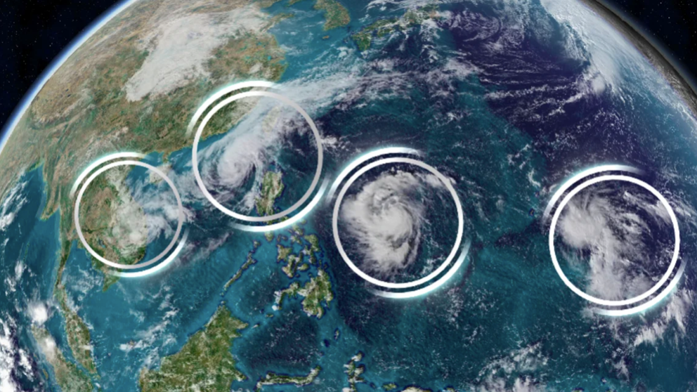
According to CNN, in the past week, four storms have formed and moved across the Western Pacific Ocean at the same time. This is considered a rare phenomenon caused by warmer oceans.
The Japan Meteorological Agency confirmed on November 12 that this was the first time four storms had formed at the same time in November in this area since 1951.
Satellite imagery from the Joint Typhoon Warning Center shows four storms spanning the vast Western Pacific basin, stretching from Vietnam to Guam. The four storms are named Typhoon Yinxing, Typhoon Toraji, Tropical Storm Usagi and Tropical Storm Man-Yi.
The Philippines is hit by several typhoons every year, but the high frequency of last month’s back-to-back storms has complicated recovery efforts in the Southeast Asian nation, with thousands still struggling to stay alive in shelters.
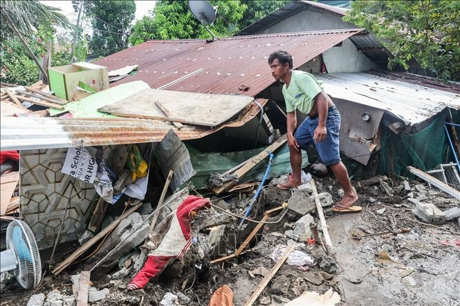
Typhoon Yinxing made landfall in the northeastern Philippines on November 7 with winds equivalent to a Category 4 Atlantic hurricane. No casualties were reported, but the storm caused torrential rains, storm surges, and landslides in the area.
After moving across the Philippines and into the South China Sea, Typhoon Yinxing headed west to China's Hainan province before turning south to Vietnam and causing heavy rains across the country.
Philippine President Ferdinand Marcos Jr. visited communities in Cagayan and Iloco Norte that were severely affected by Typhoon Yinxing.
Earlier this week, in the Philippines, thousands of people continued to evacuate as Typhoon Toraji made landfall on the east coast of Aurora province on Luzon island with winds equivalent to a Category 1 Atlantic hurricane.
Toraji is expected to weaken as it moves over the South China Sea and could bring over 100 mm of rain to parts of southeastern China.
However, the Philippines is forecast to continue to prepare for a major storm, Usagi, which is currently located 750 km from Luzon. The tropical storm is expected to strengthen into a typhoon by the evening of November 13 local time as it approaches the Philippines.
The fourth storm to follow Usagi is Tropical Storm Man-Yi, currently about 430 kilometers east of Rota, Guam. Man-Yi is forecast to continue moving west, reaching typhoon strength by the morning of November 15 and potentially hitting the northeastern Philippines early next week.
It is not yet clear whether Usagi and Man-Yi will make landfall directly in the Philippines, but heavy rains, gusty winds and dangerous storm surges are still possible.
This year, millions of people in the Philippines were severely affected by six consecutive typhoons that made direct landfall.
In July, the Philippine capital Manila and parts of Luzon saw devastating flooding brought by Typhoon Gaemi. In September, the country was also hit by powerful Typhoon Yagi, which killed dozens of people after sweeping across southern China and Southeast Asia.

Typhoon Trami and Typhoon Kong-Rey caused severe flooding and landslides on the main island of Luzon in late October, killing 150 people.
According to the Philippine disaster response center, more than 9 million people were affected by the two storms, with nearly 300,000 people evacuated.
Southeast Asia is already one of the world’s most vulnerable regions to climate change, experts warn. This year’s record-warm ocean temperatures have provided a huge source of energy for storms to grow and develop. Warmer oceans caused by human-caused fossil fuel burning are expected to bring more major storms later this year and make them more common in the future.