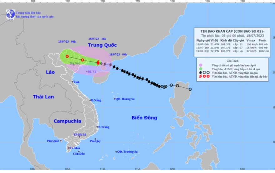
At 4:00 a.m. this morning, July 18, the center of storm No. 1 was at 21.4 degrees North latitude, 109.3 degrees East longitude, 140 km from Mong Cai (Quang Ninh).

Forecast map of storm trajectory and intensity at 5:00 a.m. on July 18
According to the provincial Hydrometeorological Station, due to the influence of storm No. 1, Bach Long Vi Island (Hai Phong) has strong winds of level 7, gusting to level 10, Cua Ong has strong gusts of level 6, and Co To (Quang Ninh) has gusts of level 7.
At 4:00 a.m. on July 18, the center of the storm was located at about 21.4 degrees North latitude; 109.3 degrees East longitude, in the northeastern area of the Gulf of Tonkin, about 140 km East Southeast of Mong Cai (Quang Ninh). The strongest wind near the center of the storm was level 10-11 (89-117 km/h), gusting to level 14.
It is forecasted that in the next 24 hours, storm No. 1 will move in the West-Northwest direction at a speed of 20 km/h, directly affecting the mainland of the northeastern provinces of the North and weakening.
At 4:00 a.m. on July 19, the storm moved deep inland, continued to weaken and gradually dissipated.
Due to the influence of the storm, from the morning of July 18, the wind will gradually increase to level 4-5, sometimes level 6, gusting to level 6. Hai Duong province will have rain, moderate rain, then heavy rain to very heavy rain and thunderstorms. Rainfall in the northeastern part of the province is from 80-150 mm; in the southwestern part of the province is from 50-100 mm, higher in some places. During thunderstorms, there is a possibility of tornadoes, lightning and strong gusts of wind. Beware of flooding in urban areas and low-lying areas.
PV