
 giảm 1 cấp, tiến vào Vịnh Bắc Bộ")
 phòng chống bão số 3")
 sơ tán ngay tối 6/9 để tránh bão số 3")

.jpg "Hủy 12 chuyến tàu để tránh siêu bão số 3, tuyến Hà Nội - Hải Phòng có 6 chuyến")
 đổ bộ miền Nam Trung Quốc, giới chức gia hạn cảnh báo cao nhất")

")

-d0772b57e88f948e139a9a67176fefdf.jpg "Forecast: Hai Duong is about to welcome the return of cold air")


.jpg "Kim Thanh reclaims more than 234 hectares of land to build an industrial park")


.jpg "Binh Giang's first quarter budget revenue reached nearly half of the province's annual target.")
.jpg "Early spring tea")
Submit a comment
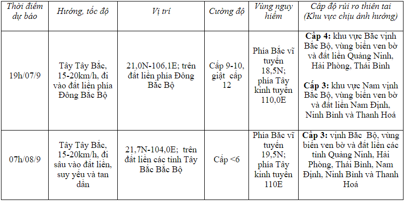
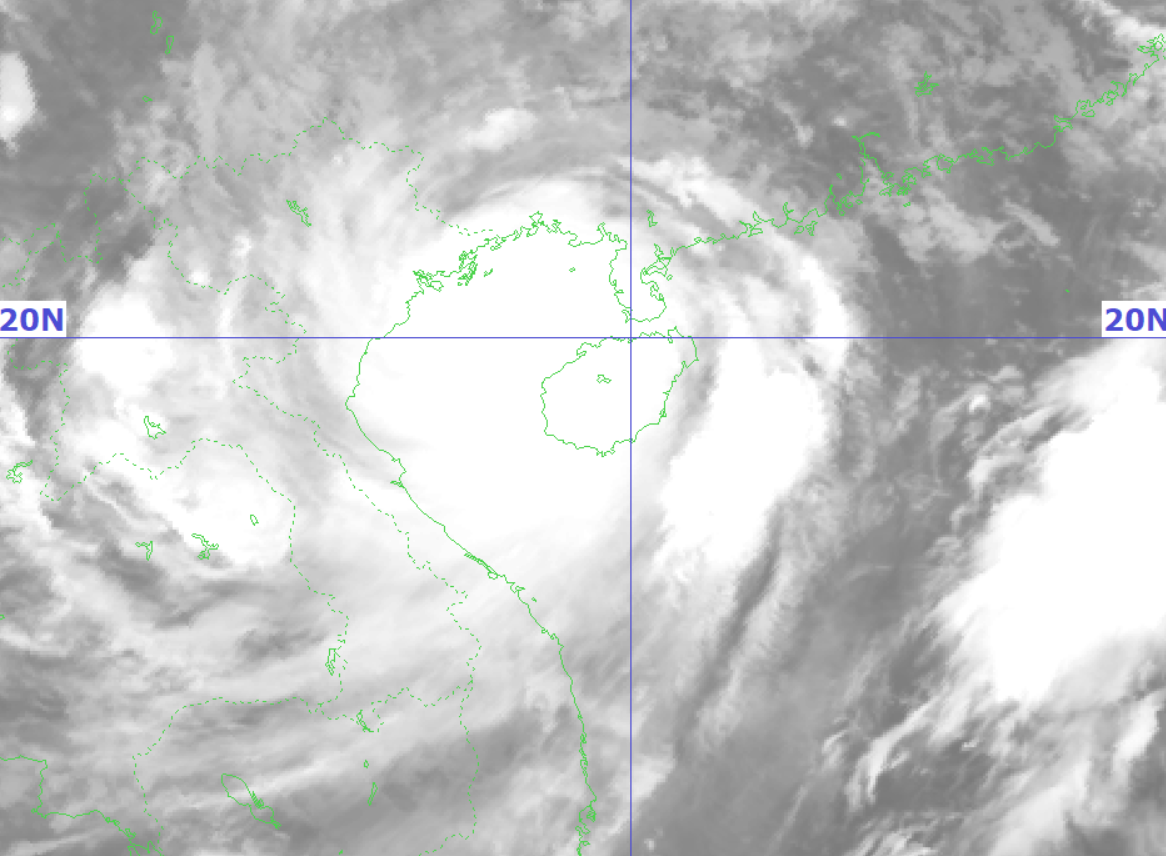
On the morning of September 7, storm No. 3 (Yagi) moved in the Gulf of Tonkin at a speed of 15-20 km/h, level 14 intensity, gusting to level 17, and is forecast to make landfall in Quang Ninh - Hai Phong this afternoon. The Hai Duong Province Hydrometeorological Station forecasts that on the morning of September 7, there will be strong winds of level 6-8, gusting to level 9-11, with the strongest winds from morning to evening.
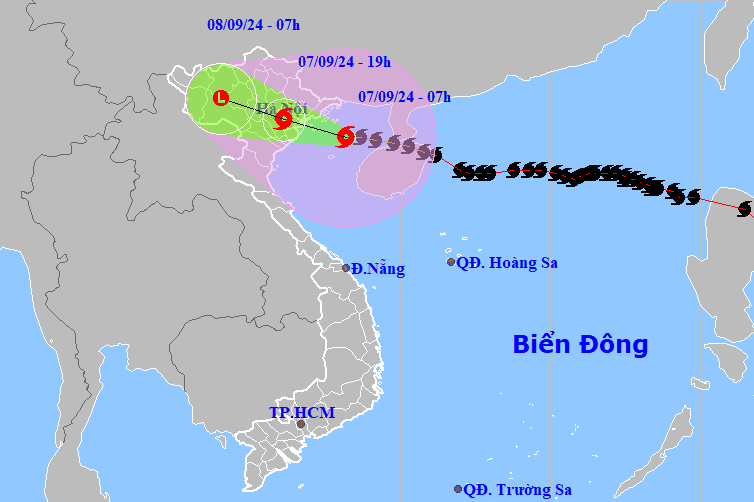
According to the National Center for Hydro-Meteorological Forecasting, at 8:00 a.m. on September 7, the center of storm No. 3 was located at about 20.4 degrees North latitude, 108 degrees East longitude, about 132km from the coast of Quang Ninh - Hai Phong. The strongest wind near the center of the storm was level 14 (150-166km/h), gusting to level 17, moving in a West-Northwest direction at a speed of 15-20km/h.
Due to the influence of storm No. 3, Bach Long Vi island has strong winds of level 12, gusting to level 14. Co To island has strong winds of level 7, gusting to level 11. Mong Cai has strong winds of level 6, gusting to level 9. Cua Ong (Quang Ninh) has strong winds of level 8, gusting to level 9.
Storm forecast for the next 24 to 48 hours:
At sea, the Gulf of Tonkin (including Bach Long Vi and Co To island districts) has strong winds of level 9-11, near the storm's eye level 12-14, gusting to level 17; waves 3-5m high, near the storm's eye 6-8m, rough seas.
On land, coastal areas from Quang Ninh to Thanh Hoa have strong winds of level 6-7, then increasing to level 8-9, near the storm center level 10-12, gusting to level 14; waves 2-4m high.

Coastal areas from Thanh Hoa to Quang Ninh need to be on guard against storm surges of 0.5m (Thanh Hoa) - 2m (Quang Ninh) in the afternoon and night of September 7. Coastal areas from Quang Ninh to Hai Phong need to be on guard against receding water of about 0.5m in the morning and noon of September 7.
Boat mooring areas, aquaculture areas, dykes and seawalls in the above-mentioned dangerous areas are all likely to be affected by strong winds, big waves and storm surges/ebb. Low-lying coastal and river mouth areas should be on guard against the risk of flooding due to surges and big waves.

From September 7 to the morning of September 9, in the Northern region and Thanh Hoa, a widespread heavy rain is forecast to occur with total rainfall ranging from 100-350mm, with some places over 500mm. The heaviest rain in the Northeast will be concentrated during the day and night of September 7, and in the Northwest from the evening of September 7 to the night of September 8.
Heavy rain can cause flooding in low-lying areas, flash floods in small rivers and streams, and landslides on steep slopes.
Due to the influence of the wide storm circulation, in the Northwest region, the area from Nghe An to Thua Thien Hue needs to be on guard against the risk of thunderstorms, tornadoes, and strong gusts of wind.
Since early morning of September 7, Hai Duong province has had rain with average rainfall of less than 10mm. According to the provincial Hydrometeorological Station, this morning there will be strong winds of level 6-8, gusting to level 9-11 (the strongest winds are from morning to evening). Natural disaster risk level due to storm: level 3.


.jpg "Hai Duong's agricultural, forestry and fishery value increased by 7.51% in the first quarter.")