
.jpg "Hủy 12 chuyến tàu để tránh siêu bão số 3, tuyến Hà Nội - Hải Phòng có 6 chuyến")


.jpg "Hai Duong welcomes heavy rain after nearly 8 months")

.jpeg "Hai Duong heavy rain and thunderstorms")
.jpg "Hai Duong requests to close 49 full landfills")


.jpg "Invite you to read Hai Duong newspaper special issue")
.jpeg "People rush to complete real estate procedures before 'G hour'")


.jpg "Outstanding domestic and international events on April 25")

.jpg "Agree on proposal to exempt and support tuition fees for students")
.jpg "Woman in Bac Ninh illegally bought and sold invoices worth more than 6,000 billion VND")
.jpg "US President Donald Trump announced that Chinese President Xi Jinping had contacted")

.jpg "Noi Bai Airport is expected to welcome 108,000 passengers on the peak day of April 30.")

.jpg "Hai Duong Power conducts disaster prevention and incident response drills in 2025")

Submit a comment
In the past 3 hours, storm No. 3 (storm Yagi) has decreased by 1 level. Due to the influence of storm No. 3's circulation, Bach Long Vy island has strong winds of level 7, gusting to level 9.
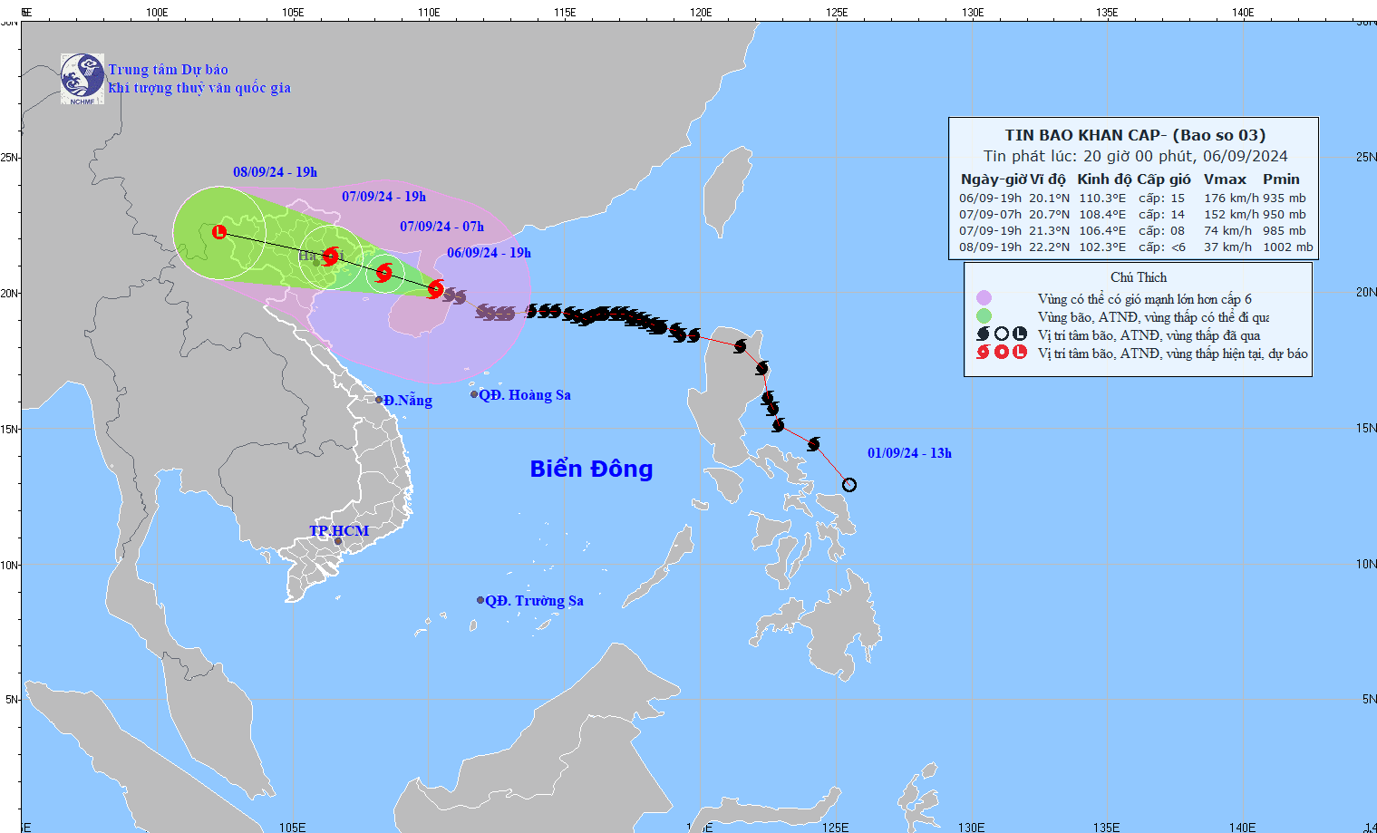
According to the National Center for Hydro-Meteorological Forecasting, in the past 3 hours, storm No. 3 (storm Yagi) has decreased by 1 level. Due to the influence of storm No. 3's circulation, Bach Long Vy island has strong winds of level 7, gusting to level 9.
At 7:00 p.m. on September 6, the center of storm No. 3 was located at approximately 20.1 degrees North latitude; 110.3 degrees East longitude, on the northern coastal area of Hainan Island (China); approximately 360 km East Southeast of Quang Ninh. The strongest wind near the center of the storm was level 15 (167-183 km/h), gusting to level 17, moving in a West Northwest direction at a speed of 15-20 km/h.
Forecast of storm developments in the next 24 to 48 hours as follows:
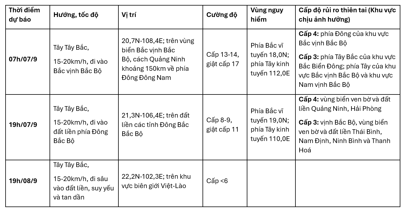
Informing reporters of press agencies this afternoon, Mr. Mai Van Khiem - Director of the National Center for Hydro-Meteorological Forecasting said that it is forecasted that around tonight, storm number 3 will enter the Gulf of Tonkin.
According to Mr. Mai Van Khiem, the main impacts of storm No. 3 need to be noted:
Firstly, about strong winds: Storm No. 3 can cause strong winds of level 16, gusting to level 17 in the North East Sea; level 13-14, gusting to level 17 in the North Gulf of Tonkin; level 11-12, gusting to level 14 in coastal waters of Quang Ninh, Hai Phong, and Thai Binh.
Second is about big waves and storm surges: In the East Sea, waves can be 10-12m high, in coastal areas along the coast of Quang Ninh - Thanh Hoa from 2-5m.
Third is about heavy rain: Storm No. 3 can cause heavy rain in the Northern and North Central provinces, focusing on the Northern region and Thanh Hoa with rainfall from 100-350mm, in some places over 500mm.
Specifically about strong winds, from the night of September 6 and early morning of September 7, coastal areas from Quang Ninh to Thanh Hoa will have winds gradually increasing to level 6-7, then increasing to level 8-9, areas near the storm center will have winds of level 10-12, gusting to level 14.
The first place to receive strong winds on land is likely to be the Mong Cai area (Quang Ninh), from about 1-4am on September 7. The strongest winds will be from noon to evening on September 7.
The inland areas of the Northeast, including provinces such as Lang Son, Bac Giang, Hai Duong, Hung Yen, Ha Nam, Ninh Binh and Thanh Hoa, will have stronger winds later and weaker, generally at level 6-8, gusting to level 9-11 from noon on September 7.
TH (according to Vietnamnet)


.jpg "The violator has removed the surrounding wall and iron net around the Bac Hung Hai bridge pillar.")