


.jpg "Chairman of Hai Duong Provincial People's Committee Le Ngoc Chau: Equitable energy transition opens up a new, sustainable growth model")

.jpg "More than 100 students participated in updating knowledge on just energy transition")


.jpg "Nam Sach completed the repair of temporary and dilapidated houses the earliest in the province.")
.jpg "Solidarity in localities after merger")


-6c1d92d2bb9c2e2762f005bb0c312955.jpg "Strongly handle dirty food")

.jpg "Hai Duong implements issuance of agricultural land use right certificates")
 demolished the illegal construction.")


Submit a comment
It is forecasted that this weekend, a low pressure area will form in the East Sea, which may strengthen into a tropical depression, causing heavy rain in the Northern and Central Central regions.
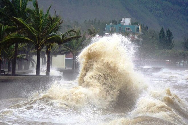
The National Center for Hydro-Meteorological Forecasting said that currently, the tropical convergence zone is passing through the central area of the East Sea. On July 13-14, the tropical convergence zone is likely to form a low pressure area (which may strengthen into a tropical depression), directly affecting the northern and central areas of the East Sea, then affecting the Gulf of Tonkin and the central sea.
Around July 14-16, the North and Central Central regions are likely to experience widespread moderate to heavy rain.
According to the meteorological agency, from now until August 10, there may be 1-2 storms or tropical depressions appearing in the East Sea, which could affect mainland areas.
There will be many days of showers and thunderstorms nationwide, with the risk of some widespread moderate and heavy rain lasting about 2-4 days. People need to be on guard against thunderstorms, tornadoes, lightning, and hail.
In the North, Central, Central Highlands and South regions, total rainfall is approximately above the average of many years. In other places in the North, total rainfall is generally approximately below.
In the next month, heat waves will continue to occur in the North and Central regions. The average temperature across the country will generally be 0.5-1 degrees Celsius higher, with the South Central, Central Highlands and South regions being about 0.1-0.5 degrees Celsius higher than the average for the same period in many years.
TH (according to VTC News)
.jpg "Results of the 2024 Administrative Reform Index of departments, branches, sectors and district-level People's Committees in Hai Duong")
