

.jpg "Sáp nhập tỉnh, thành phố không chỉ là tinh gọn trên bản đồ")
.png "Roll call of 84 provincial cities when district level is abolished")


-a9f705f0fc2bb442b889e7ca8cfb4e9f.jpg "See detailed retirement age table")
.jpg "Harm others, blame yourself for giving the car to a child")


.jpg "Special cooperative")
.jpg "Baidu Releases AI Model Competing with DeepSeek for Free")
.jpg "French President strongly declares sending troops to Ukraine")
.png "Vietnam faces 'not rich yet old'")

.jpg "How long do you have to work at a company to get pregnant?")


.jpg "Health sector completes measles vaccination campaign in March")
Submit a comment
Administrative map of 63 provinces and cities of the Socialist Republic of Vietnam shows the division and administrative management at the provincial level within the territory of Vietnam, including mainland, sea, islands and archipelagos across the country.
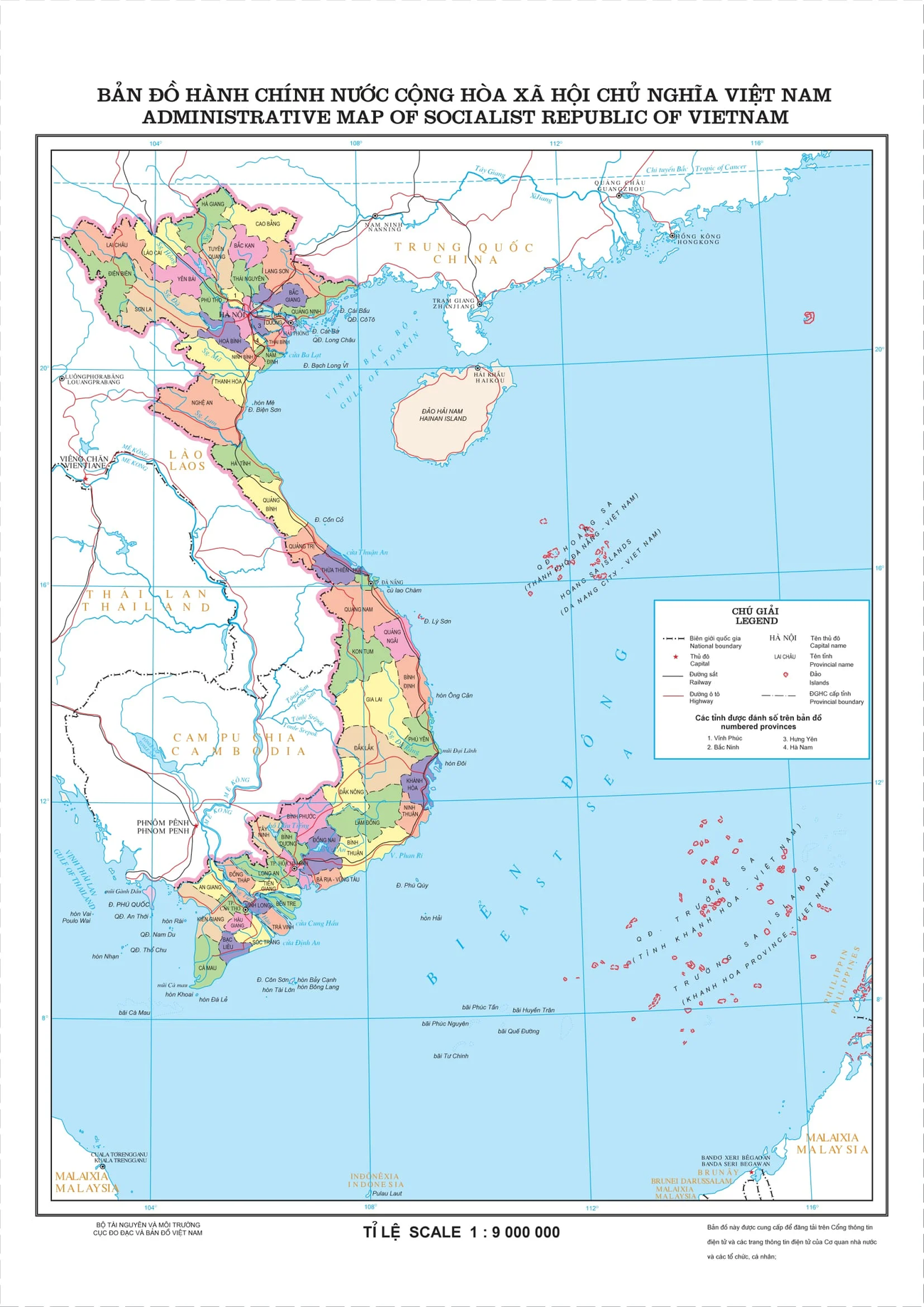
The administrative map of 63 provinces and cities of the Socialist Republic of Vietnam was published by the Department of Surveying and Mapping, Ministry of Natural Resources and Environment (now the Ministry of Agriculture and Environment) at a scale of 1:9,000,000, showing the division and administrative management at the provincial level of Vietnam's territory including mainland, sea, islands and archipelagos across the country.
The content of the administrative map of the Socialist Republic of Vietnam with 63 provinces and cities is specified in Article 7 of Circular 47/2014/TT-BTNMT including:
- Mathematical basis elements: Frames in the map; latitude and longitude grid; coordinate points, national elevation; scale notes, scale ruler.
- Professional factors: National borders and administrative boundaries.
- Geographical background factors: Hydrology; terrain; population; socio-economics; transportation.
- Other elements: Map name; legend; population area table; supplementary map; name of the governing body; name of the unit that created the map; name and origin of the document that created it; name of the publisher and person responsible for publishing; name of the unit that printed the product; publishing license information; copyright; year of publication.
TB (summary).jpg "The Standing Committee of the National Assembly Party Committee gave opinions on some contents on the arrangement and streamlining of the apparatus.")
