


.jpg "26 earthquakes occurred in March at 'hot spots' in Kon Tum and Quang Nam")


.jpg "In the North, there are places with severe cold.")
.jpg "Forecast for the new week, Hai Duong welcomes increased cold air")


.jpeg "Hanoi has 189 more measles cases in the past week")


.jpg "5,000 Japanese audiences excited for the 'Brothers Overcoming a Thousand Thorns'")

.jpg "Domestic gold price continues to climb, surpassing 102 million VND per tael")


Submit a comment
According to the National Center for Hydro-Meteorological Forecasting, on the morning of July 21, the tropical depression in the Hoang Sa archipelago strengthened into a storm, the second storm of 2024.
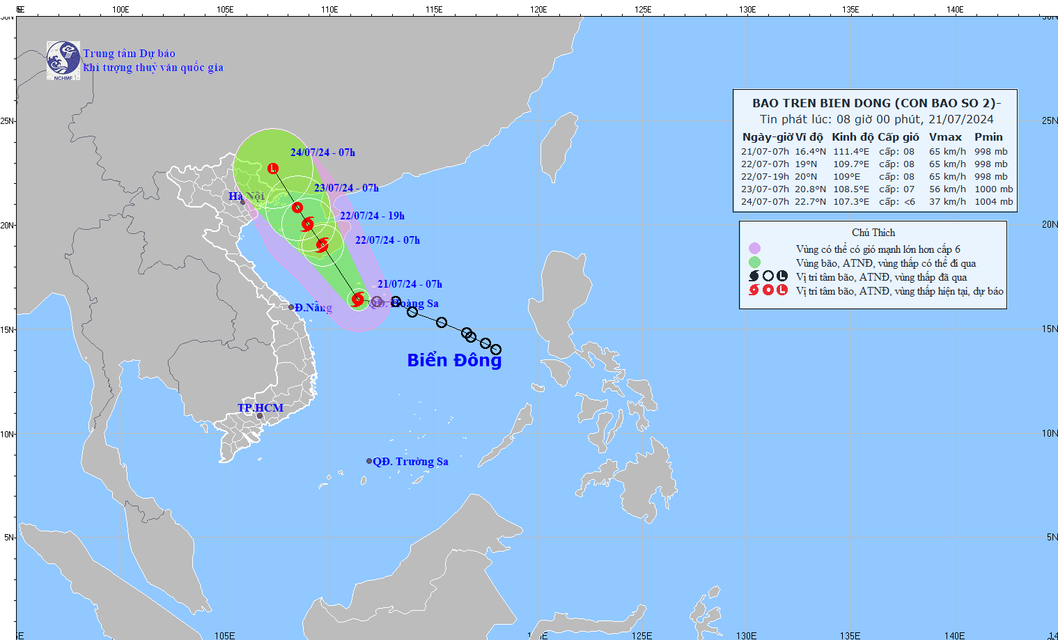
At 7:00 a.m., the center of the storm was at approximately 16.4 degrees North latitude; 111.4 degrees East longitude, in the Hoang Sa archipelago. The strongest wind near the center of the storm was level 8 (62 - 74 km/h), gusting to level 10, moving in the West Northwest direction at a speed of 10 - 15 km/h.
Forecast until 7:00 a.m. on July 22, the storm is moving northwest, speed 10 - 15 km/h, storm location at 19.0 N-109.7E; on Hainan Island (China). Storm intensity is level 8, gust level 10, danger zone 15.0N-21.0N; 108.0-113.0E, natural disaster risk level 3; affected areas are the western sea area of the North and Central East Sea (including Hoang Sa Island), the eastern sea area from Quang Tri to Quang Ngai.
At 7:00 a.m. on July 23, the storm moved northwest at a speed of about 10 km/h into the Gulf of Tonkin and gradually weakened, with the storm located at 20.8N-108.5E; in the northern area of the Gulf of Tonkin. The storm intensity is level 6-7, gusting to level 9, the dangerous area is north of latitude 17.0N; 106.5-112.0E, the natural disaster risk level is level 3; the affected area is the western sea area of the North East Sea (including Hoang Sa island), the Gulf of Tonkin area.
At 7:00 a.m. on July 24, the storm moved northwest at a speed of about 10 km/h and gradually weakened into a low pressure area, located at 22.7N-107.3E; on the mainland southwest of Guangxi province (China), the storm intensity was below level 6, the dangerous area was north of latitude 18.5N; west of latitude 111.0E, the natural disaster risk level was level 3, the affected area was the northern area of the Gulf of Tonkin.
Experts say that due to the influence of the storm, the western sea area of the North and Central East Sea (including Hoang Sa Island), the eastern sea area from Quang Tri to Quang Ngai will have strong winds of level 6 - 7, the area near the storm's center will have strong winds of level 8, gusts of level 10, and rough seas.
The sea area west of the North and Central East Sea (including Hoang Sa island), the sea area east of Quang Tri to Quang Ngai area, waves are 2 - 4 m high, the area near the storm center is 3 - 5 m.

.jpg "Hai Duong approved 50 people to quit their jobs according to Decree 178 and 67")
