


.jpeg "Xuất hiện áp thấp nhiệt đới trên Biển Đông, nhiều nơi mưa lớn")
.jpg "26 earthquakes occurred in March at 'hot spots' in Kon Tum and Quang Nam")


.jpg "In the North, there are places with severe cold.")
.jpg "Forecast for the new week, Hai Duong welcomes increased cold air")


.jpeg "Hanoi has 189 more measles cases in the past week")


.jpg "5,000 Japanese audiences excited for the 'Brothers Overcoming a Thousand Thorns'")

.jpg "Domestic gold price continues to climb, surpassing 102 million VND per tael")


Submit a comment
On the morning of July 20, the National Center for Hydro-Meteorological Forecasting updated the latest information on the location of the tropical depression in the East Sea.
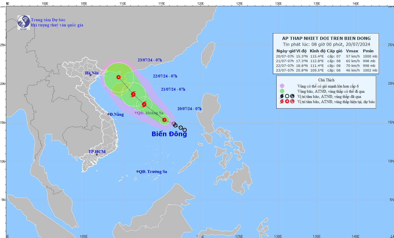
Information Center, at 7:00 a.m. on July 20, the center of the tropical depression was at about 15.3 degrees North latitude; 115.4 degrees East longitude, about 420km East Southeast of Hoang Sa archipelago. The strongest wind near the center of the tropical depression was level 7 (50-61km/h), gusting to level 9; moving in the West Northwest direction at a speed of 10-15km/h.
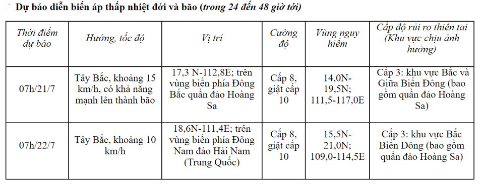
From the next 48 to 72 hours, the storm will move northwest, traveling 10-15km per hour and gradually weaken.
The North and Central East Sea areas have heavy showers and thunderstorms, strong winds of level 6-7, then increasing to level 8, gusting to level 10, very rough seas. The North and Central East Sea areas have waves 2.0-4.0m high.
Forecast of strong waves, high winds, thunderstorms at sea
The tropical convergence zone has an axis at about 14-16 degrees North latitude connecting with the tropical depression at 7:00 a.m. on July 20, located at about 15.3 degrees North latitude; 115.4 degrees East longitude.
On Phu Quy island, there were strong gusts of wind at level 9. The North East Sea, Central and South East Sea (including the waters of Hoang Sa and Truong Sa archipelagos), Ca Mau to Kien Giang and the Gulf of Thailand had showers and thunderstorms.
In addition, during the day and night of July 20, the eastern part of the North East Sea, the central and southern East Sea (including the waters of the Truong Sa archipelago), the northern Gulf of Tonkin, the waters from Binh Thuan to Ca Mau, Ca Mau to Kien Giang and the Gulf of Thailand will have showers and thunderstorms. During thunderstorms, there is a possibility of tornadoes and strong gusts of wind of level 7-8.
The warning center said that on the day and night of July 21, the North East Sea area (including the waters of Hoang Sa archipelago) will have strong winds of level 8, gusting to level 10; waves from 2.5 to 4.5 meters high; very rough seas.
The central East Sea area has strong winds of level 6-7, gusting to level 9; waves from 2.0-4.0m high; very rough seas.
The sea area from Khanh Hoa to Binh Thuan, between the East Sea and the West of the South East Sea (including the West of Truong Sa archipelago) has strong southwest winds of level 6, gusting to level 7-8; waves from 2.0-3.0m high; rough seas. Disaster risk level due to strong winds at sea: level 2.
All vessels operating in the above areas are at high risk of being affected by cyclones, strong winds and large waves.

.jpg "Hai Duong approved 50 people to quit their jobs according to Decree 178 and 67")
