


.jpg "Seized a large amount of processed food without invoices or documents in Hai Duong City")

.jpg "Hai Duong handles 217 traffic violations in the first half day of the holiday")


.png "Podcast News April 30")


.jpg "Mother Buoi has husband and son who sacrificed for the Fatherland")

Submit a comment
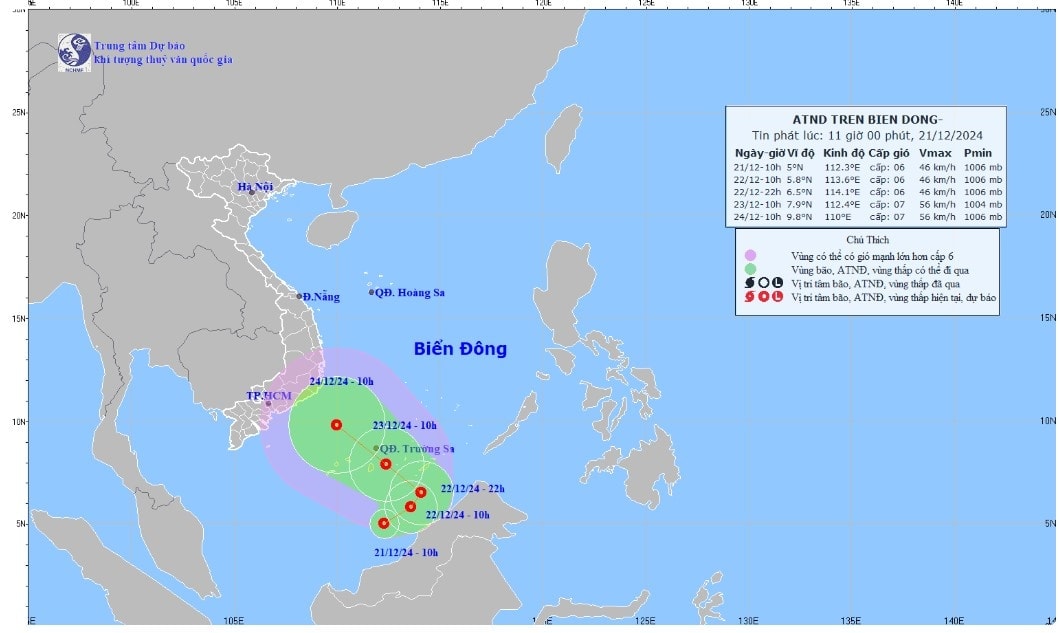
The low pressure area in the southern East Sea has strengthened into a tropical depression this afternoon, and is forecast to move south of the Truong Sa archipelago in the next two days.
Accordingly, the Minister of Agriculture and Rural Development issued telegram No. 9764/CD-BNN-DD: People's Committees of coastal provinces and cities from Phu Yen to Ca Mau; Ministries: National Defense, Public Security, Natural Resources and Environment, Transport, Industry and Trade, Information and Communications, Foreign Affairs; Vietnam Television, Voice of Vietnam, Vietnam News Agency.
The National Center for Hydro-Meteorological Forecasting said at 10am today, the tropical depression in the southern sea of the South China Sea, the strongest wind is 49 km/h, level 6, gusting to level 8 and moving little.
It is forecasted that by 10am tomorrow, the tropical depression will maintain its intensity over the southern waters of the South China Sea, moving northeast at a speed of 5 km/h. By the evening of the same day, it will change direction to northwest.
At 10am on December 23, the tropical depression will strengthen to level 7, gusting up two levels, in the sea area south of the Truong Sa archipelago. International stations such as Japan and Hong Kong have not yet commented on this tropical depression.
Due to the influence of the tropical depression, the southern sea of the South China Sea will have strong winds of level 6, gusts of level 8, and waves of 3-5 m high. From tomorrow night, the southern sea of the Truong Sa archipelago will have strong winds of level 6-7, gusts of level 8-9, and waves of 4-6 m high.
The meteorological agency warns that ships operating in the above-mentioned dangerous areas are likely to be affected by storms, whirlwinds, strong winds, and large waves.
Since the beginning of the year, the East Sea has seen 9 storms and a tropical depression, including storms Prapiroon, Yagi, Soulik, Trami and Yinxing, which directly affected mainland Vietnam. The strongest storm was Yagi, which made landfall in Quang Ninh, Hai Phong and affected 25 northern provinces and cities, including Thanh Hoa. The storm, floods and landslides that followed left 513 people dead and missing, with total economic losses estimated at VND84,900 billion.
To proactively respond to the developments of the tropical depression, the Ministry of Agriculture and Rural Development requests ministries, branches, and People's Committees of coastal provinces and cities from Phu Yen to Ca Mau to closely monitor the developments of the tropical depression; strictly manage means of transport going out to sea; organize counting and notify owners of means of transport, captains of ships and boats operating at sea of the location, direction of movement and developments of the tropical depression so that they can proactively avoid, escape or not move into dangerous areas. Dangerous areas in the next 24 hours: from latitude 4.0-7.5, from longitude 110 - 115.5 (dangerous areas are adjusted in forecast bulletins).
Vietnam Television, Voice of Vietnam, Vietnam News Agency, the coastal information station system and mass media agencies from central to local levels have increased measures to inform authorities at all levels, owners of means of transport operating at sea and people about the developments of the tropical depression so that they can proactively prevent and respond.
Provinces and cities are ready with forces and means to rescue when requested.
Ministries and branches, according to their functions, state management tasks and assigned tasks, proactively direct and coordinate with localities to respond to tropical depressions.


