


.jpg "Seized a large amount of processed food without invoices or documents in Hai Duong City")

.jpg "Hai Duong handles 217 traffic violations in the first half day of the holiday")


.png "Podcast News April 30")


.jpg "Mother Buoi has husband and son who sacrificed for the Fatherland")

Submit a comment
According to the National Center for Hydro-Meteorological Forecasting, the tropical depression is more than 400 km from Da Nang city.
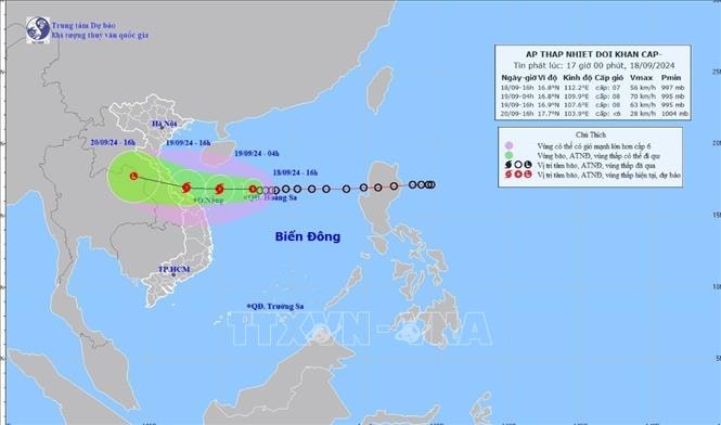
At 4:00 p.m. on September 18, the center of the tropical depression was at about 16.8 degrees North latitude; 112.2 degrees East longitude, in the Hoang Sa area, about 430 km East Northeast of Da Nang. The strongest wind near the center of the tropical depression was level 7 (50 - 61 km/h), gusting to level 9; moving mainly in a westerly direction at a speed of about 15 km/h. It is forecasted that in the next 12 hours, the tropical depression is likely to strengthen into a storm, with an intensity of level 8, gusting to level 10.
At 4:00 p.m. on September 19, the storm moved westward at a speed of about 20 km/h, strengthening into a storm; the storm's eye was located in the coastal waters from Quang Tri to Quang Nam; the strongest wind near the storm's eye was level 8, gusting to level 10; the natural disaster risk level was level 3.
At 4:00 p.m. on September 20, the storm moved west-northwest at a speed of about 15-20 km/h, entered the mainland and gradually weakened into a low pressure area over Thailand.
It is forecasted that the western sea area of the North East Sea (including Hoang Sa area), the sea area from Nghe An to Quang Ngai (including Ly Son island district, Cu Lao Cham, Con Co, Hon Ngu) will have strong winds of level 6-7, waves of 2-4m high, the area near the storm's center will have winds of level 8 (62 - 74 km/h), gusts of level 10 (89 - 102 km/h), waves of 3-5m high, rough seas. Ships operating in the above dangerous areas are likely to be affected by storms, whirlwinds, strong winds, and big waves. Coastal areas of provinces from Quang Binh to Quang Nam need to be on guard against storm surges of 0.3 - 0.5m high, combined with high tides and big waves causing landslides of sea dykes, embankments, and flooding in low-lying areas.
On land, from early morning and September 19, coastal mainland areas from Ha Tinh to Quang Ngai will have winds gradually increasing to level 6-7, near the storm's eye level 8 (62 - 74 km/h), gusting to level 10 (89 - 102 km/h); deep inland, winds will gust to level 6-7.
From the evening of September 18 to September 20, the North Central and Central Central regions will have heavy to very heavy rain with rainfall ranging from 100 - 300mm, locally over 500mm. From the evening of September 18 to September 19, the Central Highlands and the South will have moderate rain, heavy rain and thunderstorms, locally very heavy rain with rainfall ranging from 30-60mm, some places over 100mm, rain concentrated in the afternoon and at night. Heavy rain and localized heavy rain are likely to cause flooding in low-lying areas; flash floods on small rivers and streams, landslides on steep slopes.
Weather forecast for the night of September 18-19, the Northwest region is cloudy, with scattered showers and thunderstorms in the afternoon and evening, sunny during the day; light winds; in thunderstorms there is a possibility of tornadoes, lightning and strong gusts of wind. The lowest temperature is 23-26 degrees Celsius, some places below 22 degrees Celsius. The highest temperature is 31-34 degrees Celsius, some places above 34 degrees Celsius.
The Northeast region is cloudy, with scattered showers and thunderstorms in the late afternoon and at night, with scattered showers and thunderstorms in the plains; intermittent sunshine during the day; light winds; tornadoes, lightning and strong gusts of wind are possible during thunderstorms. The lowest temperature is 24-27 degrees Celsius. The highest temperature is 31-34 degrees Celsius, with some places above 34 degrees Celsius.
Hanoi capital is cloudy, with occasional showers and thunderstorms in the late afternoon and at night, and intermittent sunshine during the day. North wind level 2-3; in thunderstorms there is a possibility of tornadoes, lightning and strong gusts. Lowest temperature 25-27 degrees Celsius. Highest temperature 32-34 degrees Celsius.
Provinces from Thanh Hoa to Thua Thien - Hue are cloudy with moderate rain, heavy rain and thunderstorms, locally very heavy rain, especially in the area from Ha Tinh to Thua Thien - Hue there will be heavy to very heavy rain and thunderstorms; North to Northwest wind level 3-4; in thunderstorms there is a possibility of tornadoes, lightning and strong gusts of wind. Lowest temperature 23-26 degrees Celsius. Highest temperature 27-30 degrees Celsius.
Provinces and cities from Da Nang to Binh Thuan are cloudy, the North (Da Nang to Quang Ngai) has heavy to very heavy rain and scattered thunderstorms; the South in the late afternoon and evening has scattered showers and thunderstorms, locally heavy rain. West to Southwest wind level 3-4; in thunderstorms there is a possibility of tornadoes, lightning and strong gusts. The lowest temperature is 24-27 degrees Celsius. The highest temperature is 28-31 degrees Celsius in the North, 30-33 degrees Celsius in the South, some places above 33 degrees Celsius.
The Central Highlands region is cloudy with moderate to heavy rain and scattered thunderstorms, locally very heavy rain. Southwest wind level 3; in thunderstorms there is a possibility of tornadoes, lightning and strong gusts. Lowest temperature 20-23 degrees Celsius. Highest temperature 25-28 degrees Celsius, some places above 28 degrees Celsius.
The Southern region is cloudy with moderate to heavy rain and scattered thunderstorms, with some places experiencing very heavy rain. Southwest wind level 3; thunderstorms are likely to cause tornadoes, lightning and strong gusts of wind. Lowest temperature 23-26 degrees Celsius. Highest temperature 28-31 degrees Celsius, with some places experiencing over 31 degrees Celsius.


