


.jpg "Hải Dương hoàn chỉnh kịch bản kỹ lưỡng ứng phó bão số 3")


")

-d0772b57e88f948e139a9a67176fefdf.jpg "Forecast: Hai Duong is about to welcome the return of cold air")


.jpg "Kim Thanh reclaims more than 234 hectares of land to build an industrial park")


.jpg "Binh Giang's first quarter budget revenue reached nearly half of the province's annual target.")
.jpg "Early spring tea")
Submit a comment
So far, storm No. 3 (super typhoon Yagi) remains at level 16, gusting over level 17, moving west at a speed of 15 - 20km/h. It is forecasted that by 10am on September 7, the storm will enter the northern Gulf of Tonkin.
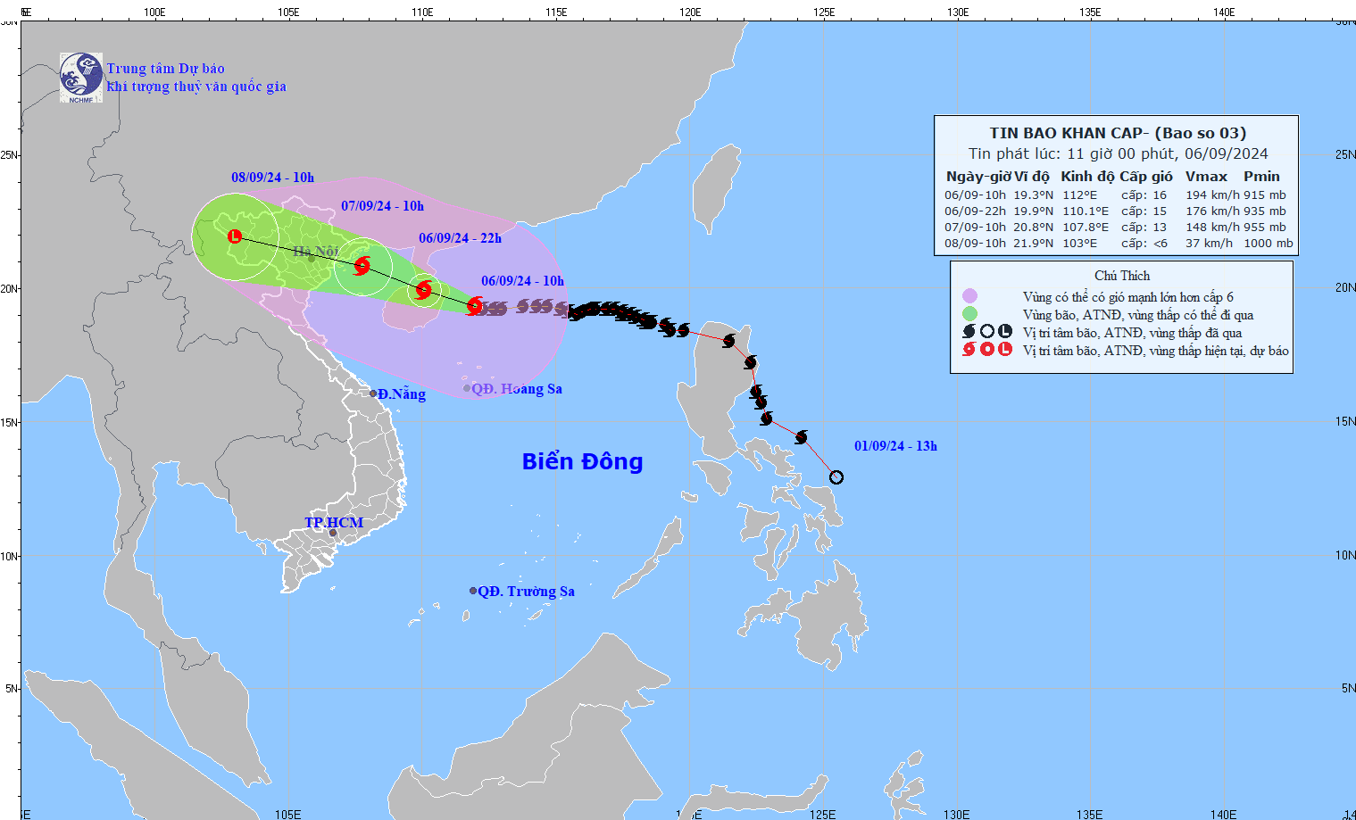
According to the National Center for Hydro-Meteorological Forecasting, at 10:00 a.m. on September 6, the center of the super typhoon was located at approximately 19.3 degrees North latitude; 112.0 degrees East longitude, approximately 130km East Southeast of Hainan Island (China); approximately 570km East Southeast of Quang Ninh. The strongest wind near the center of the super typhoon was level 16 (184 - 201km/h), gusting to level 17, moving westward at a speed of 15 - 20km/h.
Forecast until 22:00 on September 6, the storm will move in the West Northwest direction, speed 15 - 20km/h, storm location at 19.9N-110.1E; on the mainland north of Hainan Island, about 350km east southeast of Quang Ninh, storm intensity level 15, gusting above level 17; dangerous area is north of latitude 17.0N; west of longitude 114.0E, natural disaster risk level 4, affected area northwest of the North East Sea; Level 3: east of the North Gulf of Tonkin.
At 10:00 a.m. on September 7, the storm moved in the West-Northwest direction, at a speed of 15 - 20 km/h, entering the North Gulf of Tonkin, the storm's location was at 20.8N-107.8E; in the sea area of Quang Ninh - Nam Dinh provinces, the storm intensity was level 12 - 13, gusting to level 15; the dangerous area was north of latitude 18.0N; west of longitude 111.5E, disaster risk level 4, the affected area was east of the North Gulf of Tonkin, disaster risk level 3, the affected area was west of the North Gulf of Tonkin and South Gulf of Tonkin.
At 10:00 a.m. on September 8, the storm moved in the West Northwest direction, at a speed of about 20km/h, entered the mainland and weakened and gradually dissipated, the storm was located at 21.9N-103.0E; in the Northwest region, the storm intensity was below level 6, disaster risk level 4, the affected areas were coastal waters and mainland of Quang Ninh, Hai Phong, disaster risk level 3 for the Gulf of Tonkin, coastal waters and mainland of Thai Binh, Nam Dinh, Ninh Binh and Thanh Hoa provinces.
Due to the influence of storm No. 3, the northwest sea area of the North East Sea has strong winds of level 11 - 14, the area near the center of the super storm has winds of level 15 - 16, gusting above level 17; the sea is very rough.
From around the afternoon of September 6, the eastern sea area of the Gulf of Tonkin (including Bach Long Vi island district) will have winds gradually increasing to level 6 - 7. From the evening and night of September 6, the Gulf of Tonkin area (including Bach Long Vi island district, Co To) will have winds gradually increasing to level 8 - 9, then increasing to level 10 - 11, the area near the storm center will have winds of level 12 - 14, gusting to level 17; the sea will be very rough.
On land, from the night of September 6 and early morning of September 7, coastal areas from Quang Ninh to Thanh Hoa will have winds gradually increasing to level 6 - 7, then increasing to level 8 - 9, areas near the storm center will have winds of level 10 - 12, gusting to level 14; areas deep inland in the Northeast will have strong winds of level 6 - 8, gusting to level 9 - 11 (The strongest winds will be from morning to evening of September 7).
In Hai Duong,From tonight, September 6 to September 9, Hai Duong province will have heavy to very heavy rain and thunderstorms, with common rainfall as follows:
*The Northeastern region of the province including Chi Linh city, Kinh Mon town and Kim Thanh, Nam Sach and Thanh Ha districts has common rainfall from 200-300mm, some places over 300mm.
*The Southwest region of the province includes Cam Giang, Binh Giang, Thanh Mien, Gia Loc, Tu Ky, Ninh Giang districts and Hai Duong city with common rainfall of 250-350mm, some places over 350mm.


.jpg "Hai Duong's agricultural, forestry and fishery value increased by 7.51% in the first quarter.")