

.jpg "Hải Dương hoàn chỉnh kịch bản kỹ lưỡng ứng phó bão số 3")


Submit a comment
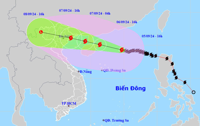
The storm will make landfall from Quang Ninh to Thanh Hoa, with coastal areas experiencing strong winds of level 12 and inland levels of level 9, causing 300-400 mm of rain on September 7-8.
On the afternoon of September 5, Deputy Prime Minister Tran Hong Ha chaired a meeting with 28 provinces, cities and relevant ministries and branches to respond to super typhoon Yagi.
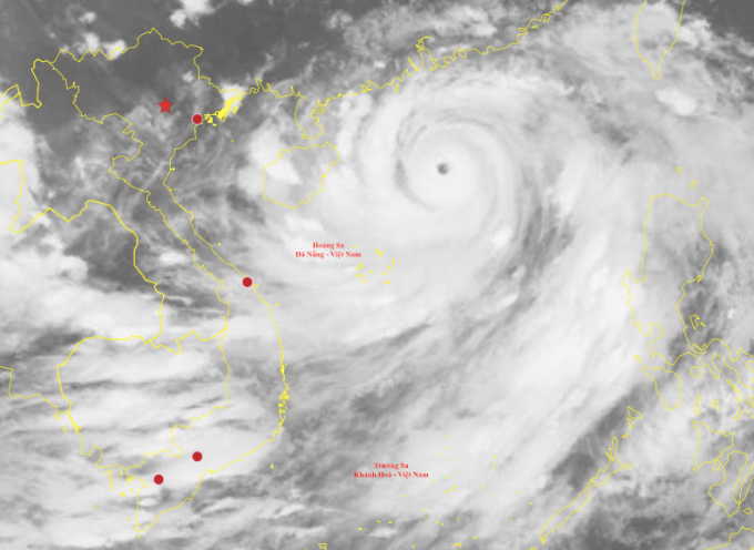
According to the National Center for Hydro-Meteorological Forecasting, at 5:00 p.m., the storm center was in the northern sea area of the North East Sea, about 380 km from China's Hainan Island, with super typhoon intensity (184-201 km/h), gusting over level 17. Over the past three days, on average, the storm increased by one level every three hours, from 8 to 16.
The super typhoon has moved west at a speed of 10-15 km/h. It is expected that from now until tomorrow evening, when it approaches the Leizhou Peninsula and China's Hainan Island, the storm will continue to maintain its super typhoon intensity. Tomorrow evening, when it crosses Hainan Island into the Gulf of Tonkin, the storm will decrease to level 13-14. From the afternoon of September 7, the storm will make landfall in the North, focusing from Quang Ninh to Thanh Hoa.
The storm has a wide circulation, with a radius of about 250 km at level 8, 150 km at level 10 and above, and 80 km at level 12. Satellite cloud images also show a very sharp eye, with a thick and very wide surrounding cloud disk.
At the meeting, Mr. Mai Van Khiem, Director of the National Center for Hydro-Meteorological Forecasting, said that international forecasting centers all believe that Yagi will maintain its super typhoon status until it nears Hainan Island. Entering the Gulf of Tonkin, the storm may decrease to level 13-14, gusting to level 16; when it reaches the mainland, it will drop to level 9-12 depending on the area, gusting to level 13-14.

Over the past two days, satellites have estimated that rainfall along the storm's path will be 200-300 mm. Yagi's rainfall is similar to that of Rammasun in 2014, which occurred in September, but this storm has many extreme factors due to its large circulation, hot weather, and high humidity. "These are unfavorable factors that can cause thunderstorms and tornadoes before the storm arrives," said Mr. Khiem.
Yagi's path is said to be similar to Typhoon Damrey in 2005. When this storm made landfall, it devastated the sea dyke system in Hai Phong, Nam Dinh, Thanh Hoa, killing 68 people. "Yagi is very strong, reaching level 13, gusting to level 16, with a high risk of destruction, so we need to be extremely vigilant," Mr. Khiem emphasized.
Due to heavy rain of 300-400 mm concentrated in two days of September 7-8, there will be widespread flooding, risk of landslides in steep slopes, and inundation in low-lying and urban areas.
Fear of floods after storm, sea dikes at risk of breaking if storm level 12
According to Mr. Pham Duc Luan, Director of the Department of Dyke Management and Natural Disaster Prevention and Control, by this afternoon, the border guards of the coastal provinces of the North and Central regions had counted and provided shelter for more than 50,000 fishing boats and nearly 220,000 people. It is expected that Hai Phong, Quang Ninh, Thai Binh, Nam Dinh, Nghe An will ban the sea from tomorrow noon, and Ninh Binh from this afternoon. There are currently more than 2,300 tourists on the islands, all of whom have received information about the storm and proactively planned their movements.
Mr. Luan is particularly worried about sea dikes and river estuaries because they are currently only designed to withstand level 9-10 storms. If a level 12 storm makes landfall, "the risk of failure is very high." Currently, from Quang Ninh to Nghe An, there are 37 key weak dike points that need special attention, of which the most are in Hai Phong with 10 points, Thai Binh and Nam Dinh each with 8 points.
Minister of Agriculture and Rural Development Le Minh Hoan said that after 10 years, the Red River Delta has had a major storm. The area affected by the storm is an economic hub, with many aquaculture, tourism, and underground mining facilities, so it needs to "act quickly to avoid regrets". There are only 24 hours left to prepare to minimize human and property damage.
"There have been many lessons about subjectivity. This time, high-risk areas need to be publicized, plans prepared, crowded activities limited, and storm shelters inspected early," said the Minister. Tomorrow, the Ministry will organize delegations to inspect vulnerable areas to prepare response plans.
Localities are required to resolutely not let people stay in cages when the storm hits. With winds of force 13, boats can sink right at their anchorage if not properly secured. Residents and tourists must be evacuated from semi-permanent houses. Depending on the situation, localities may allow students to stay home from school.
The authorities of the northern provinces and cities need to organize the pruning of tree branches, the tying up of houses; focus on harvesting rice and aquatic products with the motto "green house is better than ripe field". The authorities recommend that people do not participate in traffic during the storm, from Saturday morning they should stay at home.
In his directive speech, Deputy Prime Minister Tran Hong Ha noted the need to closely monitor the storm's path and provide more detailed information, such as the warning level and dangerous risks, so that people can visualize what a level 12 storm would be like. Forecasting agencies must work with greater intensity, forecast regularly, and provide complete and accurate data.
The Deputy Prime Minister is particularly concerned about the rain after the storm causing flash floods and landslides. Every force, organization and leader must fulfill their responsibilities well, not be lax or subjective. "From today until noon tomorrow, if necessary, we must forcibly evacuate tourists like we did with people in aquaculture areas," said the Deputy Prime Minister.
TH (according to VnExpress)