


.jpg "26 earthquakes occurred in March at 'hot spots' in Kon Tum and Quang Nam")


.jpg "In the North, there are places with severe cold.")
.jpg "Forecast for the new week, Hai Duong welcomes increased cold air")


.jpeg "Hanoi has 189 more measles cases in the past week")


.jpg "5,000 Japanese audiences excited for the 'Brothers Overcoming a Thousand Thorns'")

.jpg "Domestic gold price continues to climb, surpassing 102 million VND per tael")


Submit a comment
It is forecasted that from October 1 to 2, the water level of Thao River will continue to rise rapidly. During this flood, the flood peak on small rivers in Lao Cai and Yen Bai provinces is likely to reach alert level 2 - alert level 3.
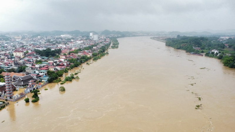
According to the National Center for Hydro-Meteorological Forecasting, the water level on the Thao River is rising rapidly. At 7:00 a.m. on October 1, the water level on the Thao River in Lao Cai was 80.04m (0.04m above alert level 1), and in Yen Bai it was 27.03m (2.97m below alert level 1).
It is forecasted that from October 1 to 2, the water level of Thao River will continue to rise rapidly. During this flood, the flood peak on small rivers in Lao Cai and Yen Bai provinces is likely to reach alert level 2 - alert level 3, the water level in Yen Bai is at alert level 2 (with the expected discharge of Dong Sung Hydropower Plant at 2,500m3/s).
The meteorological agency warned of a high risk of flooding in low-lying areas along rivers in Lao Cai, Yen Bai, Ha Giang and Tuyen Quang provinces, and flash floods and landslides on steep slopes in mountainous areas of the North.
From the morning of September 30 to the morning of October 1, the Northern provinces, Thanh Hoa and Nghe An had moderate to heavy rain, such as: Nam Xe 1 (Lai Chau) 93.8mm; So Lo 1 Hydropower Plant (Hoa Binh) 85.6mm; Ta Giang Phinh (Lao Cai) 291.8mm; Thuong Son 1 (Ha Giang) 284.6mm; Mo Vang (Yen Bai) 215.4mm; Hoi Xuan (Thanh Hoa) 162mm; Luu Kien 1 (Nghe An) 126mm...
Soil moisture models show that some areas in the above provinces are nearly saturated (over 85%) or have reached saturation. On the afternoon of October 1, the above provinces continued to have rain with average amounts of 30-60mm, in some places over 90mm.
The National Center for Hydro-Meteorological Forecasting warned of the risk of flash floods on small rivers and streams, and landslides on steep slopes in many districts of the provinces of Lai Chau, Dien Bien, Son La, Hoa Binh, Lao Cai, Yen Bai, Ha Giang, Tuyen Quang, Phu Tho, Bac Kan, Thai Nguyen, Cao Bang, Thanh Hoa and Nghe An.
According to hydrometeorological experts, flash floods and landslides can have very negative impacts on the environment, threaten people's lives; cause local traffic congestion, affect the movement of vehicles; destroy civil and economic works, causing damage to production and socio-economic activities. Local authorities need to pay attention to reviewing bottlenecks and vulnerable locations in the area to take preventive and response measures.
Meanwhile, the cold air mass continues to affect the North, then the North Central and some places in the Central Central. The wind changes to the Northeast at level 3 inland, level 4-5 in coastal areas.
During this cold spell, the weather in the North and North Central regions will be cool; nights and early mornings will be cold, especially in the mountainous areas of the North. The lowest temperature in the North and Thanh Hoa is generally 19-22 degrees Celsius, in mountainous areas 17-19 degrees Celsius, in high mountainous areas below 16 degrees Celsius; in Nghe An-Ha Tinh, the lowest temperature is generally 20-23 degrees Celsius.
At sea, from noon on October 1, the wind in Bac Bo Gulf will change direction to Northeast, gradually increasing to level 6, gusting to level 7-8; rough sea; waves 2-3m high.
TB ổn định ở mức trên báo động III từ 0,38-0,43 m")

.jpg "Hai Duong approved 50 people to quit their jobs according to Decree 178 and 67")
