


")

-d0772b57e88f948e139a9a67176fefdf.jpg "Forecast: Hai Duong is about to welcome the return of cold air")


.jpg "Kim Thanh reclaims more than 234 hectares of land to build an industrial park")


.jpg "Binh Giang's first quarter budget revenue reached nearly half of the province's annual target.")
.jpg "Early spring tea")
Submit a comment
According to the National Center for Hydro-Meteorological Forecasting, the ENSO phenomenon continues to maintain La Nina status at about 80-90%, with the risk of heavy rain and storms in the last months of the year, especially in the Central region.
According to the national hydro-meteorological forecasting agency, from now until the end of 2024, ENSO (including the El Nino and La Nina phenomena) will shift to La Nina state, causing many dangerous weather patterns.
Regarding specific information about the weather situation in the coming time, Deputy Head of Weather Forecast Department, National Center for Hydro-Meteorological Forecasting Nguyen Huu Thanh said that around July 13-14, the heat wave will end in the North and Central regions.
However, in the last days of July, the heat in the North tends to increase and last until August with about 3-4 periods, lasting 2-4 days each.
In the Central region, heat waves will continue until September, mainly concentrated in July and August 2024 with about 4-6 periods, lasting 2-4 days/period.
Heat waves and extreme heat waves are likely to occur more frequently than the average for the same period. The average temperature is generally 0.5-1 degree Celsius higher than the average for many years during the same period.
Regarding the flood situation, the total rainfall in the Northern region in July and August was generally at a level approximately equal to the average of many years; September was generally 10-20% higher, while in the Northwest region it was 5-10% lower than the average of many years.
Total rainfall from July to September in the Central region is generally 10-30% higher than the average of many years, especially in the North Central region in August, it is generally approximately equal to the average of many years.
In the Central Highlands and the South, total rainfall is generally 5-15% higher than the average of many years.
"Regions across the country continue to be at risk of dangerous weather phenomena such as thunderstorms, tornadoes, lightning and strong gusts of wind," Mr. Nguyen Huu Thanh noted.
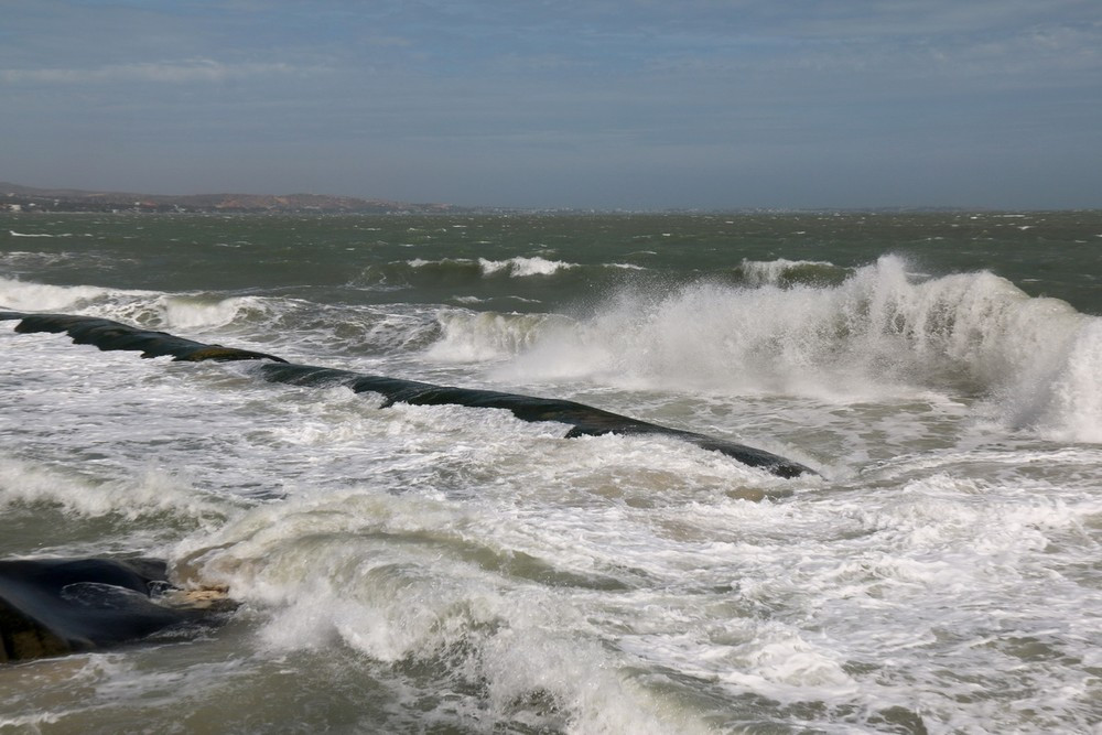
Besides, from July to September is the period of southwest monsoon activity, therefore, wave height in the offshore area of Central Vietnam, in the East Sea (including Hoang Sa area) is about 2-4m, rough sea.
")
During this period, the coastal areas of the North, North Central and Central Vietnam need to be on guard against large waves combined with rising water during storms and tropical depressions, which pose a high risk of causing landslides on riverbanks and coastlines.
The Southeast coast from now until the end of September is likely to experience high tides. However, this area is not affected by the Northeast monsoon, so the risk of flooding in low-lying areas and areas outside the dyke is low.
The water level at Vung Tau station during high tides is expected to be below 4.1m. For the coastal areas of the Southwest, from late July to August, high tides combined with large waves will appear due to the strong southwest monsoon, so it is necessary to be on guard against abnormally high sea levels causing sea dike erosion.
Commenting on the weather trend from now until the end of 2024, Deputy Director of the National Center for Hydro-Meteorological Forecasting Hoang Phuc Lam said that the ENSO phenomenon will continue to maintain La Nina status with a probability of about 80-90%, with the risk of heavy rain and storms in the last months of the year, especially in the Central region.
")
From now until the end of the year, there will be 10-12 storms and tropical depressions operating in the North East Sea, of which about 5-7 will directly affect Vietnam; the possibility of strong storms appearing in the East Sea cannot be ruled out.
Coastal areas in the North and Central regions need to continue to be on guard against large waves combined with rising water during storms and tropical depressions.
From October to December, the average temperature across the country is generally at a level approximately equal to the average of many years in the same period. In particular, in the Northern region in October 2024, the average temperature is about 0.5-1 degree Celsius higher than the average of many years in the same period.
To cope with the above dangerous weather patterns, hydrometeorological experts recommend that people need to regularly monitor forecast and warning information on the website of the National Center for Hydro-Meteorological Forecasting at nchmf.gov.vn, provincial, municipal and regional hydrometeorological stations and regularly update the latest hydrometeorological forecast information on the official mass media of the Central and local levels to proactively respond.
The government and relevant agencies need to promptly provide disaster forecast information to the people, propagate and implement an absolute ban on people's activities in areas at high risk of thunderstorms, tornadoes, lightning, hail, flash floods, landslides, etc.
People need to strictly follow the instructions of local authorities on disaster response and prevention.
TH (according to Vietnam+)


.jpg "Hai Duong's agricultural, forestry and fishery value increased by 7.51% in the first quarter.")