


")


.jpg "Kim Thanh reclaims more than 234 hectares of land to build an industrial park")


.jpg "Binh Giang's first quarter budget revenue reached nearly half of the province's annual target.")
.jpg "Early spring tea")

Submit a comment
Insmet forecasts strong waves and coastal flooding will begin on October 9 on Cuba's northwestern coast, including the Malecon sea wall that protects the capital Havana.
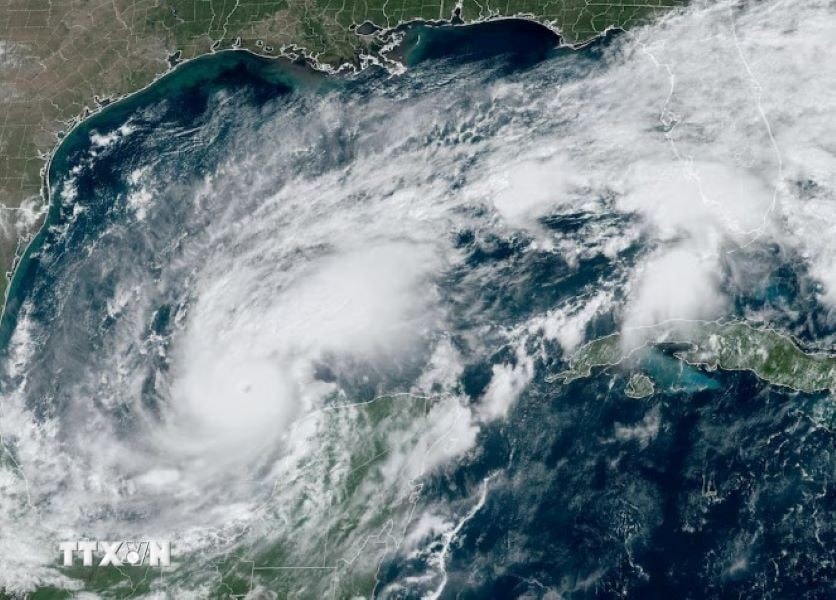
On the afternoon of October 8 (local time), the southwestern coast of Cuba began to feel the first effects of super typhoon Milton, which has now strengthened back to category 5 on the Saffir-Simpson 5-level hurricane scale and is moving towards the US at a strong speed.
The town of Surgidero de Batabanó, in the Mayabeque province, bordering the capital Havana, was completely submerged. Meanwhile, many families in the town of Cocodrilo were evacuated, and fishing boats were brought back to the mainland. The authorities and residents of the special island district of Isla de la Juventud raised their vigilance against natural disasters.
The Cuban Meteorological Institute (Insmet) warned that super typhoon Milton will cause heavy rain from October 8 to 9 in the western part of Cuba, strong winds and high waves on the southwestern coast.
Insmet forecasts strong waves and coastal flooding will begin on October 9 on Cuba's northwestern coast, including the Malecon sea wall that protects the capital Havana.
As of now, Hurricane Milton is 365km northwest of Cuba and about 830km southwest of Tampa, Florida.
Two weeks ago, Hurricane Helene swept through western Cuba, causing extensive property damage, before moving into the United States, killing more than 200 people.
The Atlantic hurricane season runs from June 1 to November 30. Meteorological and hydrological agencies predict this will be an extreme weather period with more than 20 storms, including 5 Category 3 or stronger storms on the 5-point Saffir-Simpson hurricane scale.
Since the beginning of this year, some experts have predicted that this year's tropical storm season will be "more active" than the annual average, with most major storms expected to make landfall along the continental US and Caribbean coasts.
Researchers at Colorado State University in the US explain that global warming and rising global sea levels make hurricanes more dangerous.
Meanwhile, the National Oceanic and Atmospheric Administration’s (NOAA) Climate Prediction Center predicts that there will be 17-25 tropical storms forming during this year’s hurricane season, up from the previous average of 14 storms per year. NOAA predicts that there will be 4-7 major storms, which are Category 3 or higher storms with winds of 178 km/h, up from the usual average of 3 storms.
In Cuba, Insmet experts said 11 tropical storms could reach hurricane strength in the North Atlantic, Caribbean Sea and Gulf of Mexico. There is an 80% chance that Cuba will be hit by a tropical storm or hurricane in 2024.
TH (according to VNA)


.jpg "Hai Duong's agricultural, forestry and fishery value increased by 7.51% in the first quarter.")