


.jpg "Dự báo lũ các sông ở Hải Dương tiếp tục lên nhanh")


.jpg "Invite you to read Hai Duong newspaper special issue")
.jpeg "People rush to complete real estate procedures before 'G hour'")


.jpg "Outstanding domestic and international events on April 25")

.jpg "Agree on proposal to exempt and support tuition fees for students")
.jpg "Woman in Bac Ninh illegally bought and sold invoices worth more than 6,000 billion VND")
.jpg "US President Donald Trump announced that Chinese President Xi Jinping had contacted")

.jpg "Noi Bai Airport is expected to welcome 108,000 passengers on the peak day of April 30.")

.jpg "Hai Duong Power conducts disaster prevention and incident response drills in 2025")

Submit a comment
The level of natural disaster risk due to floods and inundations is specified in Article 45 of Decision 18/2021/QD-TTg:
Accordingly, the level of natural disaster risk due to floods and inundations is specified as follows:
1. Level 1 natural disaster risks include the following cases::
a) Forecast of high flood levels from alert level 1 to below alert level 2 at hydrological stations in area 1, area 2, area 3 on a river basin;
b) Flood water level forecast from alert level 2 to below alert level 3 at hydrological stations in area 1 on a river basin.
2. Level 2 natural disaster risks include the following cases::
a) Forecast of high flood levels from alert level 1 to below alert level 2 at hydrological stations in area 4 on a river basin;
b) Forecast of high flood levels from alert level 2 to below alert level 3 at hydrological stations in area 2 and area 3 on a river basin;
c) Forecast of high flood levels from alert level 3 to below alert level 3 plus 1.0 m at hydrological stations in area 1 and area 2 on a river basin;
d) Forecast of high flood levels from alert level 1 to below alert level 3 at hydrological stations in area 1 or high flood levels from alert level 1 to below alert level 2 at hydrological stations in area 2 and area 3 on many river basins.
3. Level 3 natural disaster risks include the following cases::
a) Flood water level forecast is from alert level 2 to below alert level 3 plus 0.3m at hydrological stations in region 4;
b) Flood water level forecast from alert level 3 or higher at hydrological stations in region 3;
c) Flood water level forecast from alert level 3 plus 1m or higher at hydrological stations in area 1 and area 2;
d) Forecast of high flood levels from alert 1 to below alert 2 at hydrological stations in area 4 or high flood levels from alert 2 to below alert 3 at hydrological stations in area 3 or high flood levels from alert 2 to below alert 3 plus 1m at hydrological stations in area 2 or high flood levels from alert 3 to below alert 3 plus 1m at hydrological stations in area 1 on many river basins.
4.Level 4 disaster riskoccurs when the flood level is forecast to be from alert level 3 plus 0.3m to historical flood at hydrological stations in region 4.
5.Level 5 disaster riskoccurs when the forecast flood level exceeds historical flood levels at hydrological stations in region 4.
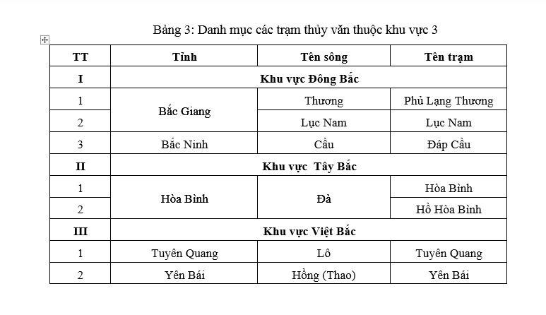
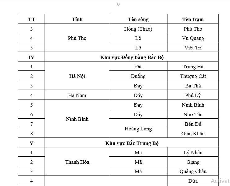
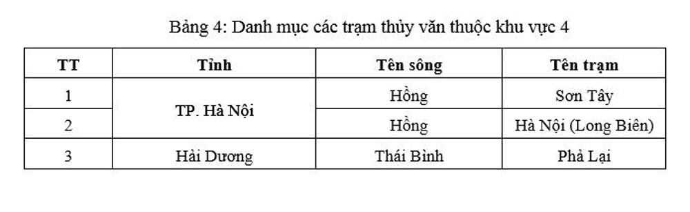
6.The list of hydrological stations in regions 1, 2, 3 and 4 is specified in detail in Appendix XIII of this Decision.
7.In case the forecast area has many areas with different levels of natural disaster risk, the risk level will be taken according to the highest level.
8.In places with flood prevention and control works, historical flood levels are replaced by design flood levels.
9.Based on the actual needs of disaster prevention and control, provinces/cities under the Central Government shall coordinate with the Ministry of Natural Resources and Environment to determine the disaster risk level for hydrological stations (flood warning locations) in the management area not specified in this Decision.
PV
.jpg "The violator has removed the surrounding wall and iron net around the Bac Hung Hai bridge pillar.")