

.jpeg "Xuất hiện áp thấp nhiệt đới trên Biển Đông, nhiều nơi mưa lớn")


")

-d0772b57e88f948e139a9a67176fefdf.jpg "Forecast: Hai Duong is about to welcome the return of cold air")


.jpg "Kim Thanh reclaims more than 234 hectares of land to build an industrial park")


.jpg "Binh Giang's first quarter budget revenue reached nearly half of the province's annual target.")
.jpg "Early spring tea")
Submit a comment
Localities affected by low pressure and low pressure circulation need to take precautions against flash floods and landslides, minimizing the impact of natural disasters on people's lives, livelihoods and production.
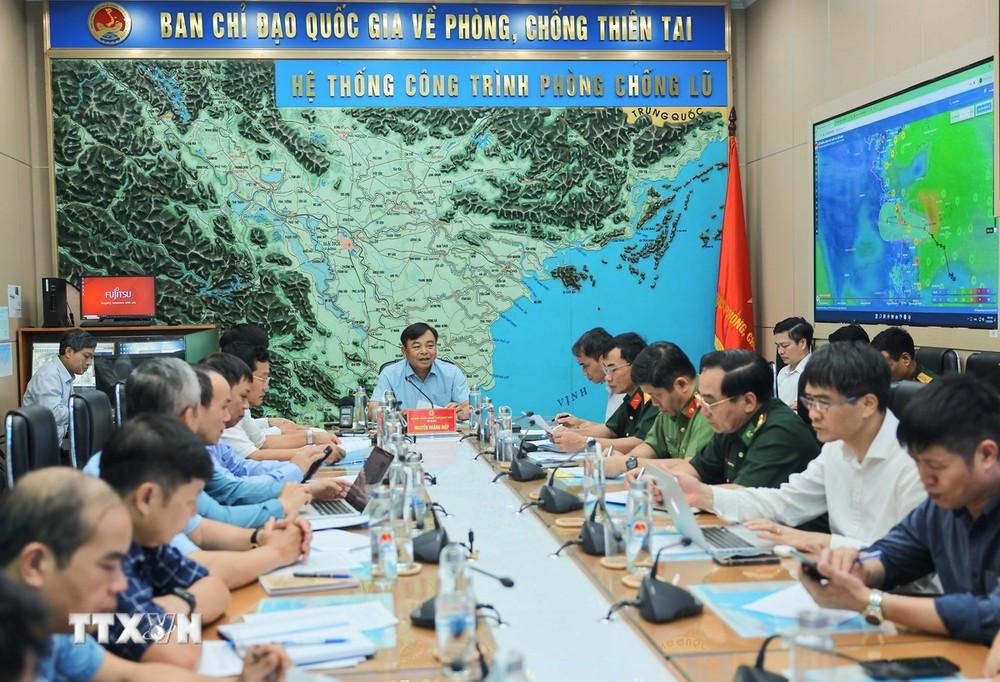
On July 15, the Ministry of Agriculture and Rural Development held a meeting to respond to tropical depression and heavy rain.
Deputy Minister of Agriculture and Rural Development Nguyen Hoang Hiep chaired the conference.
Speaking at the meeting, Deputy Minister Nguyen Hoang Hiep highly appreciated the forecasting and warning work of the National Center for Hydro-Meteorological Forecasting; thereby helping ministries, branches and localities to be proactive in directing, responding and reducing damage.
To cope with natural disasters in the coming days, especially heavy rain, Deputy Minister Nguyen Hoang Hiep requested affected areas to review their sewer and ditch systems, mobilize functional forces to conduct inspections, remove obstacles that cause water blockages, and clear the flow to minimize urban flooding.
Localities affected by low pressure and low pressure circulation need to be on guard against flash floods and landslides, minimizing the impact of the above types of natural disasters on people's lives, livelihoods and production.
"The tropical depression is likely to weaken, but coastal localities need to be on guard against heavy rain and thunderstorms," Deputy Minister Nguyen Hoang Hiep noted.
Mr. Nguyen Hoang Hiep also requested the Department of Irrigation to review all irrigation reservoirs and direct localities to promptly drain water when situations arise.
Referring to the natural disaster situation in the coming time, Deputy Minister Nguyen Hoang Hiep said that natural disasters will continue to develop complicatedly, so ministries, branches and localities need to proactively monitor the forecast and warning situation of the National Hydrometeorological Agency and the reality in the locality to proactively respond.
"After the landslide in Ha Giang on July 13 caused serious consequences, should the authorities study and strengthen warnings for vehicles not to travel at night, especially during the rainy and stormy season? If the authorities find that the traffic situation, embankments, natural disasters... are unsafe, they should implement a ban on people and vehicles passing through this dangerous area, especially at night," Deputy Minister Nguyen Hoang Hiep emphasized.
In addition, the Deputy Minister requested localities to strengthen inspections and prepare plans to ensure the safety of reservoirs and downstream areas, especially small hydropower reservoirs and important irrigation reservoirs; arrange permanent forces to be ready to operate, regulate and handle situations...
Deputy Director of the National Center for Hydro-Meteorological Forecasting Hoang Phuc Lam said that the tropical depression is currently moving in a West-Northwest direction at a speed of about 10km/h, with strong winds of level 6 (39-49km/h), gusting to level 8. At around 7:00 a.m. on July 16, the tropical depression moved in a West-Northwest direction at a speed of about 15km/h and gradually weakened into a low pressure area.
")
Due to the influence of the tropical depression, the northwest sea area of the area between the East Sea and the southwest sea area of the North East Sea (including the Hoang Sa sea area) and the offshore sea area from Quang Binh to Quang Ngai will have showers and heavy thunderstorms, strong winds of level 6, gusts of level 8, and rough seas.
The sea area from Binh Dinh to Ca Mau, the South East Sea area (including the sea area of Truong Sa) has strong winds of level 6, gusts of level 8-9, rough seas. The Gulf of Tonkin has strong winds of level 5, sometimes level 6, rough seas.
Under the influence of the tropical depression and low pressure circulation, from July 15-17, the plains and coastal areas of the North, Central Highlands and South will have rainfall of 50-100mm, locally over 200mm. The North and Central Central regions will have rainfall of 70-150mm, locally over 250mm. The mountainous areas of the North, the North Central region and the Southern Central Highlands should be on guard against the possibility of flash floods and landslides.
According to the report of the Border Guard Command, as of 6:00 a.m. on July 15, the Border Guard force had counted and instructed 40,146 ships/196,741 people to know the location and direction of the tropical depression to proactively avoid it, of which 1,037 ships/6,187 people were operating in the sea area from Quang Tri-Quang Ngai and the Hoang Sa area. Thua Thien-Hue province has banned the sea since the afternoon of July 14.
TB (according to VNA)


.jpg "Hai Duong's agricultural, forestry and fishery value increased by 7.51% in the first quarter.")