


.jpg "Hai Duong took 33 samples of medicine, milk and functional foods for quality testing.")
.jpg "Be cautious about 'surfing' real estate before merging Hai Duong and Hai Phong")


.jpg "Thai Tan village (Nam Sach) is green from house to alley")


.jpg "Number of newly established enterprises in Hai Duong increased by 21.3%")


Submit a comment
After passing through the northern coast of Luzon Island (Philippines), Typhoon Yinxing is likely to enter the East Sea, becoming the 7th typhoon of 2024.
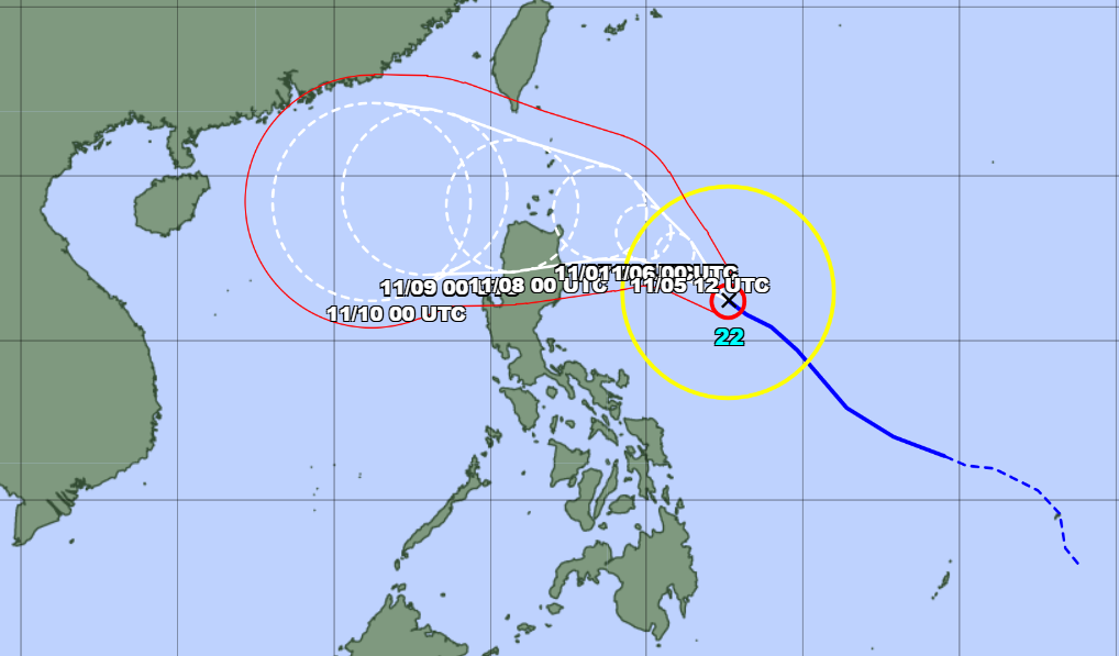
According to the Japan Meteorological Agency (JMA), at 6:00 a.m. this morning, November 5, the center of storm Yinxing was in the sea off the eastern coast of the Philippines, with the strongest winds near the center of the storm at level 11, gusting to level 14.
Today, storm Yinxing is forecast to move quite quickly in a west-northwest direction, towards the northeastern sea of Luzon Island (Philippines).
After passing the northern coast of Luzon Island, Typhoon Yinxing is likely to enter the South China Sea around November 8, becoming the seventh typhoon of 2024.
JMA predicts that storm Yinxing will continue to strengthen in the coming days, with the strongest intensity reaching level 13, gusting to level 16.
According to the National Center for Hydro-Meteorological Forecasting, currently, at Bach Long Vi station, there are strong northeast winds of level 6, gusting to level 7. The Gulf of Tonkin, the sea area from Quang Tri to Ninh Thuan, Ca Mau to Kien Giang and the Gulf of Thailand have scattered showers and thunderstorms.
Today and tonight, the Gulf of Tonkin, the central and southern East Sea, the sea area from Quang Tri to Ca Mau, Ca Mau to Kien Giang and the Gulf of Thailand are forecast to have scattered showers and thunderstorms. During thunderstorms, there is a possibility of tornadoes and strong gusts of wind of level 7-8.
The Meteorological Agency warned that on the day and night of November 6, the Gulf of Tonkin will have strong northeast winds of level 5, sometimes level 6, gusting to level 7; rough seas; waves from 1.5-2.5m high.
The North East Sea area (including the waters of Hoang Sa archipelago) has strong northeast winds of level 6-7, gusting to level 8-9; rough seas; waves 3-6m high.
From Quang Tri to Ninh Thuan, strong northeast wind level 6, gusting to level 7-8; rough sea; waves 2-4m high.
From Binh Thuan to Ca Mau, strong Northeast wind level 5, sometimes level 6, gusting to level 7-8; rough sea; waves 1-2m high.
All vessels operating in the above areas are at high risk of being affected by cyclones, strong winds and large waves.
TB (summary)
