
.png "Bão số 6 giật cấp 14, cách Hoàng Sa 230km")


")

-d0772b57e88f948e139a9a67176fefdf.jpg "Forecast: Hai Duong is about to welcome the return of cold air")


.jpg "Kim Thanh reclaims more than 234 hectares of land to build an industrial park")


.jpg "Binh Giang's first quarter budget revenue reached nearly half of the province's annual target.")
.jpg "Early spring tea")
Submit a comment
From this evening and tonight, the Central region is forecast to have heavy to very heavy rain, with the risk of flooding, flash floods and landslides in many areas.
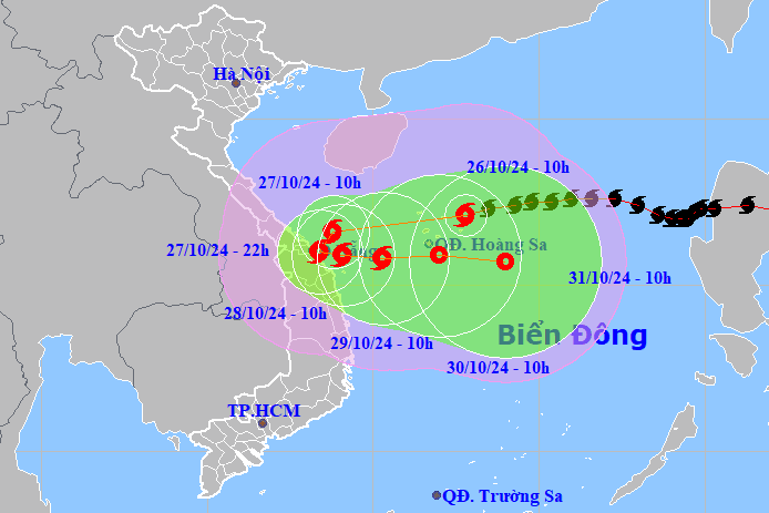
According to the National Center for Hydro-Meteorological Forecasting, at 12:00 a.m. this morning, October 26, the center of storm No. 6 (storm Trami) was at about 17.0 degrees North latitude, 112.4 degrees East longitude, in the waters of the Hoang Sa archipelago.
In the next 3 hours, the storm will move west at a speed of about 20km/h. The strongest wind near the storm center is level 11, gusting to level 14.
Forecast for the next 24 hours, storm No. 6 will maintain its direction of movement, speed 15-20km/h, intensity level 10-11, gust level 14. At 10am tomorrow morning, October 27, the storm center will be in the sea off the Central Central region.
At 10:00 a.m. on October 28, the storm changed direction, moving southwest then east at a speed of 5-10 km/h. The center of the storm was located in the coastal waters of the Central Central provinces, the intensity decreased to level 9, gusting to level 11.
In the next 24 hours, the storm will move east, slowing down to about 5km/h. At 10am on October 29, the center of storm No. 6 will be located over the sea of the Central Central provinces, with its intensity continuing to decrease to level 8, gusting to level 10.
From the next 72 to 120 hours, the storm will move mainly to the East, traveling 5-10km per hour, and its intensity will continue to weaken.
Due to the influence of storm No. 6, the western sea area of the North East Sea has strong winds of level 8-9, near the storm's eye level 10-11, gusting to level 14, waves 5-7m high, near the storm's eye 7-9m; the sea is very rough.
The sea area of provinces from Quang Binh to Quang Ngai (including Con Co Island, Cu Lao Cham, Ly Son) has strong winds of level 6-7, then increasing to level 8-9, near the storm's eye level 10-11, gusting to level 14, waves 3-5m high, near the storm's eye 5-7m; the sea is very rough.
At the same time, the meteorological agency warned that from the morning of October 27, coastal areas from Quang Binh to Quang Nam provinces may experience storm surges of 0.4-0.6m high.
Ships and boats operating in the above-mentioned dangerous areas (especially in the Hoang Sa island district), coastal areas from Quang Binh to Quang Ngai are all likely to be affected by storms, whirlwinds, strong winds, and big waves.
High risk of landslides of sea dikes and embankments along the coast of provinces from Quang Tri to Quang Nam due to the impact of big waves and storm surges.
On land, from the morning of October 27, coastal areas from Quang Binh to Quang Ngai have winds gradually increasing to level 6-7, near the storm center level 8-9, gusting to level 11.
Due to the influence of storm No. 6, from the evening and night of October 26 to October 28, from Quang Binh to Quang Ngai there will be heavy to very heavy rain with total rainfall ranging from 300-500mm, locally over 700mm.
Warning of the risk of localized heavy rain (>100mm/3 hours). Ha Tinh, Binh Dinh and the Northern Central Highlands have heavy rain, some places have very heavy rain with total rainfall from 100-200mm, some places over 300mm.
From tonight to October 29, on rivers from Ha Tinh to Binh Dinh, Kon Tum, Gia Lai, there is a possibility of a flood, with flood amplitude on rivers from 3-8m.
During this flood, the flood peak on rivers from Quang Tri to Quang Ngai reached alert level II-III, some rivers above alert level III; rivers in Quang Binh reached alert level I-II, some rivers above alert level II; rivers in Ha Tinh, Binh Dinh, Kon Tum reached alert level I.
There is a high risk of flooding in low-lying areas along rivers, flash floods and landslides on steep slopes in mountainous areas from Ha Tinh to Binh Dinh, Kon Tum, and Gia Lai.


.jpg "Hai Duong's agricultural, forestry and fishery value increased by 7.51% in the first quarter.")