


.jpg "Reading culture in the digital age")


.jpg "What to see in Hai Duong newspaper on April 21?")


-a9f705f0fc2bb442b889e7ca8cfb4e9f.jpg "Prime Minister directs early payment of pensions in May")


.jpg "Parishioners joyfully celebrate Easter at Hai Duong Church")


Submit a comment
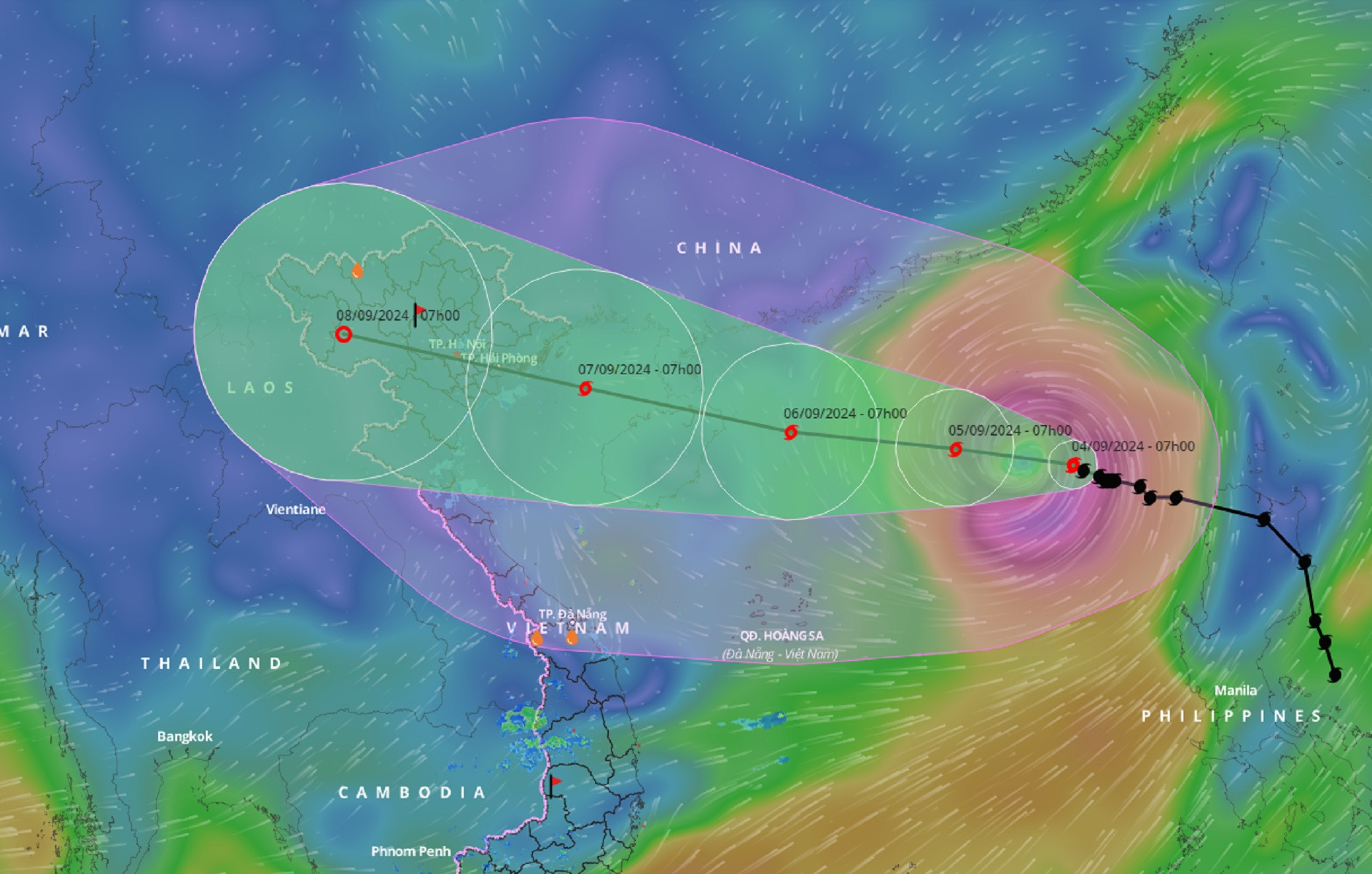
According to Dr. Mai Van Khiem - Director of the National Center for Hydro-Meteorological Forecasting, after entering the East Sea, storm Yagi has increased to level 4 and will become stronger.

On the afternoon of September 4, Minister of Agriculture and Rural Development Le Minh Hoan chaired a meeting with ministries, sectors and online with 11 coastal provinces and cities from Quang Ninh - Nghe An; Hanoi, Hung Yen, Ha Nam, Hai Duong to deploy response to storm Yagi (storm No. 3).
Typhoon Yagi could strengthen into a super typhoon
At the meeting, Dr. Mai Van Khiem - Director of the National Center for Hydro-Meteorological Forecasting said that after entering the East Sea, Typhoon Yagi has increased to level 4. Currently, the high temperature in the East Sea above 30 degrees Celsius is a condition for the storm to intensify.
Mr. Khiem assessed that in the next 24-48 hours, storm No. 3 will continue to increase in intensity as it approaches Hainan Island (China). Currently, forecasts for storm No. 3 by Vietnam and international agencies are relatively consistent in terms of direction and intensity.
In the 11am news bulletin of the same day, after review and assessment, the Vietnamese side updated additional bulletins in the next 24-36 hours.
Currently, according to wind assessment information at the observation station near Hainan Island (China), there are cases where wind force calculations can reach level 16, gusting to level 17.

"When the storm reaches level 16, it is a super storm, and there will be many impacts. The National Center for Hydro-Meteorological Forecasting is considering options this afternoon and evening and is likely to update the forecast for the storm to increase further, not just level 15 but level 16.
In case of a level 16 storm, our command plans will also change, so we must consider, review and analyze further," said Mr. Khiem.
According to current forecasts, the storm will enter the Gulf of Tonkin on the night of September 6, with an intensity of level 12-13, gusting to level 15. From September 7, heavy rain may occur in the North and North Central regions.
Mr. Khiem assessed the amount of rainfall and wind direction in the North and North Central regions depending on the wind direction of the storm. If the storm enters the Gulf of Tonkin and the mainland and deviates to the North by about 50 - 100km, the level of impact will be different.
According to Mr. Khiem, because there are still about 54 hours before the storm makes landfall in our country, there will be many changes, and forecasting agencies will continue to update to make forecasts.
Mr. Khiem said that from this evening, if the storm continues to increase in intensity, the intensity in the east of Hainan Island will be updated to level 16. On the mainland from noon to afternoon of September 7, from Quang Ninh - Thai Binh, especially Nam Dinh, there will be strong winds of level 9 - 10, gusting to level 13.
With the current path of the storm, the rainfall will be very heavy, about 200 - 300mm, possibly up to 500mm. However, if the storm moves north, the rainfall and impact will decrease.
It is expected that tomorrow morning (September 5), the National Center for Hydro-Meteorological Forecasting will issue an emergency storm bulletin, in addition to the regular bulletins updated every 3 hours, there will also be an additional bulletin updated every 1 hour. In case the storm continues to increase at a high level this afternoon and evening, there will be an additional bulletin about the super storm in the next 24-36 hours.
Instructions for 50,000 ships to avoid storms
According to the report of the Department of Crop Production (Ministry of Agriculture and Rural Development), in the North and North Central regions, there are still 15,000 hectares of summer-autumn rice in the ripening stage, it is necessary to concentrate all resources to harvest with the motto "green at home is better than ripe in the field".
About 998,000 hectares of winter-spring rice are in the growing stage, so it is necessary to mobilize all resources to dredge canals, clear water flows, and drain water early to avoid flooding when heavy rain occurs.
Regarding aquaculture, from Quang Ninh - Quang Ngai province, there are currently 166,824 hectares of area and 24,633 aquaculture cages and rafts, and 3,911 watchtowers.
According to the report of the Border Guard Command, the unit has counted and instructed more than 50,000 vehicles/219,000 people to know the developments and direction of storm No. 3 so that they can proactively move to avoid it, including 557 ships/3,703 people operating in the North East Sea and Hoang Sa archipelago.
TH (according to Vietnamnet)