


.jpg "11 big problems in science, technology, innovation and digital transformation of Hai Duong")


.jpeg "Difficult things should not be done carelessly.")


.jpg "Hai Duong traffic focus on May 10")


Submit a comment
At noon on October 18, the tropical depression in the sea area of Quang Tri - Quang Nam strengthened into storm, storm number 5.
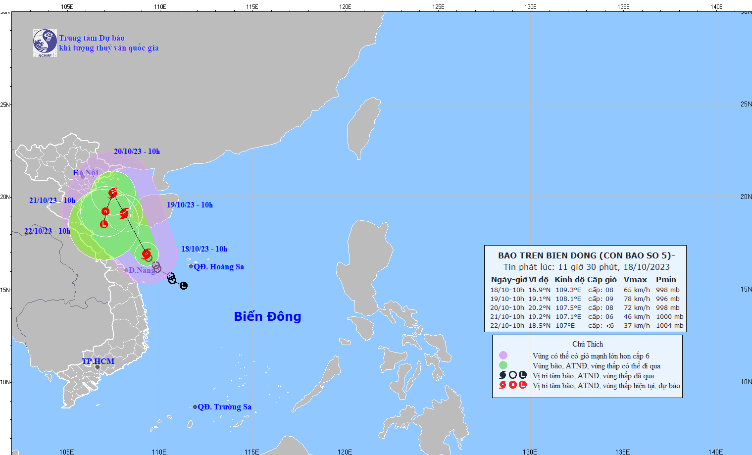
The eye of the storm is about 270 km west-northwest of Hoang Sa archipelago, about 150 km east of the mainland of Quang Tri - Quang Ngai. The strongest wind near the eye of the storm is level 8 (62 - 74 km/h), gusting to level 11.
According to the National Center for Hydro-Meteorological Forecasting, at noon on October 18, the tropical depression in the sea area of Quang Tri - Quang Nam strengthened into storm, storm number 5.
At 11:00, the center of the storm was at about 16.9 degrees North latitude; 109.3 degrees East longitude, about 270km West Northwest of Hoang Sa archipelago, about 150km East of the mainland of Quang Tri - Quang Ngai area. The strongest wind near the center of the storm was level 8 (62 - 74km/h), gusting to level 11. Moving in the North Northwest direction at a speed of about 10km/h.
Forecast until 10:00 on October 19, the storm will move in the North-Northwest direction, speed of about 10 km/h, and is likely to strengthen, the storm is located at 19.1N-108.1E; in the sea area east of the Gulf of Tonkin, the storm intensity is level 8-9, gust level 12, dangerous area is 15.0-21.0N; west of longitude 111.5E; natural disaster risk level 3, the affected area is the southwest of the North East Sea area; the Gulf of Tonkin sea area, the sea area from Quang Tri to Quang Nam.
At 10:00 a.m. on October 20, the storm moved in the North-Northwest direction, at a speed of about 5 km/h, the storm was located at 20.2N-107.5E; in the Gulf of Tonkin, the storm intensity was level 8, gusting to level 11, the dangerous area was north of latitude 16.0N; west of longitude 110.0E, the natural disaster risk level was level 3, the affected area was the Gulf of Tonkin, the sea area from Quang Tri to Thua Thien - Hue.
At around 10:00 a.m. on October 21, the storm moved in a south-southwest direction and gradually weakened into a tropical depression, located at 19.2N-107.1E; in the Gulf of Tonkin, the storm intensity was level 6, gusting to level 8, the dangerous area was north of latitude 16.0N; west of longitude 110.0E, natural disaster risk level 3, the affected area was the Gulf of Tonkin.
From the next 72 to 96 hours, the tropical depression continued to move slowly in the South Southwest direction and further weakened.
The southwestern sea area of the North East Sea, the sea area from Quang Tri to Quang Nam has strong winds of level 6 - 7, near the eye of the storm is strong winds of level 8 - 9, gusts of level 12, very rough seas. In the Gulf of Tonkin from the night of October 18, the winds will gradually increase to level 6 - 7, near the eye of the storm is strong winds of level 8 - 9, gusts of level 12. Very rough seas.
The southwestern sea area of the North East Sea (including the sea area of Hoang Sa archipelago), the sea area from Quang Tri to Quang Ngai, the waves are 2 - 4 m high, the sea area of Bac Bo Gulf from early morning and October 19, the waves increase to 2 - 4 m high, then increase to 3 - 5 m.
From the afternoon of October 18 to the morning of October 19, in the area from Quang Tri to Thua Thien - Hue, there will be moderate rain, heavy rain, and some places will have very heavy rain. From the night of October 19, the coastal areas of the North, the Southern Delta, and the North Central region will likely have moderate rain, and some places will have heavy to very heavy rain; heavy rain in the Central Central region will gradually decrease.
According to Tin Tuc newspaper


.jpg "Hai Duong completed the target of each locality building 15 new houses for policy families, poor and near-poor households.")