
.jpg "Áp thấp nhiệt đới hình thành trên Biển Đông")


.jpg "Bão Usagi giật cấp 12 đổ bộ Biển Đông, trở thành cơn bão số 9")


.jpg "Hai Duong has showers and thunderstorms during the April 30 and May 1 holidays")

.jpg "Four more communes of Gia Loc district have their waste treated at the factory.")

.jpg "Seized a large amount of processed food without invoices or documents in Hai Duong City")

.jpg "Hai Duong handles 217 traffic violations in the first half day of the holiday")


.png "Podcast News April 30")


.jpg "Mother Buoi has husband and son who sacrificed for the Fatherland")

Submit a comment
This afternoon, the tropical depression is likely to change direction from northeast to northwest, approaching Truong Sa archipelago, then approaching the coast of Phu Yen - Ca Mau provinces.
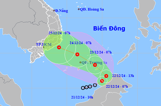
The National Center for Hydro-Meteorological Forecasting said that at 7:00 a.m. this morning, the tropical depression in the southern sea of the South China Sea had the strongest wind speed of 49 km/h, level 6, gusting to level 8, and was moving northeast at a speed of 10 km/h.
At 1 p.m. on December 22, the tropical depression will change direction, moving northwest at a faster speed and heading towards Vietnam's Truong Sa archipelago. At 7 a.m. on December 23, the tropical depression will intensify, reaching level 6-7, gusting to level 9, in the south of Truong Sa archipelago, then heading towards the coast of Phu Yen - Ca Mau provinces.
Due to the influence of cold air and tropical depression, from the night of December 23 to December 26, the Central and South Central regions will have heavy rain, locally very heavy rain with common amounts of 100-300 mm, some places over 500 mm. On December 24-25, the rain will spread to the Eastern Central Highlands with amounts of 50-100 mm, locally over 200 mm.
On December 21, the Ministry of Agriculture and Rural Development issued a telegram requesting coastal provinces and cities of Phu Yen - Ca Mau to proactively monitor the development of the tropical depression and inform ships of their direction to proactively avoid it.
Since the beginning of the year, the East Sea has seen 9 storms and one tropical depression, of which storms Prapiroon, Yagi, Soulik, Trami, and Yinxing directly affected mainland Vietnam. The strongest was storm No. 3 (storm Yagi), which made landfall in Quang Ninh, Hai Phong, and affected 25 northern provinces and cities, including Thanh Hoa. The storm and subsequent floods and landslides left 513 people dead and missing, with total economic losses estimated at VND84,900 billion.
VN (synthesis)

