


.jpg "Nam Sach completed the repair of temporary and dilapidated houses the earliest in the province.")
.jpg "Solidarity in localities after merger")


-6c1d92d2bb9c2e2762f005bb0c312955.jpg "Strongly handle dirty food")

.jpg "Hai Duong implements issuance of agricultural land use right certificates")
 demolished the illegal construction.")


Submit a comment
Experts warn that heavy rains can cause flooding in low-lying areas; flash floods in small rivers and streams; and landslides on steep slopes.
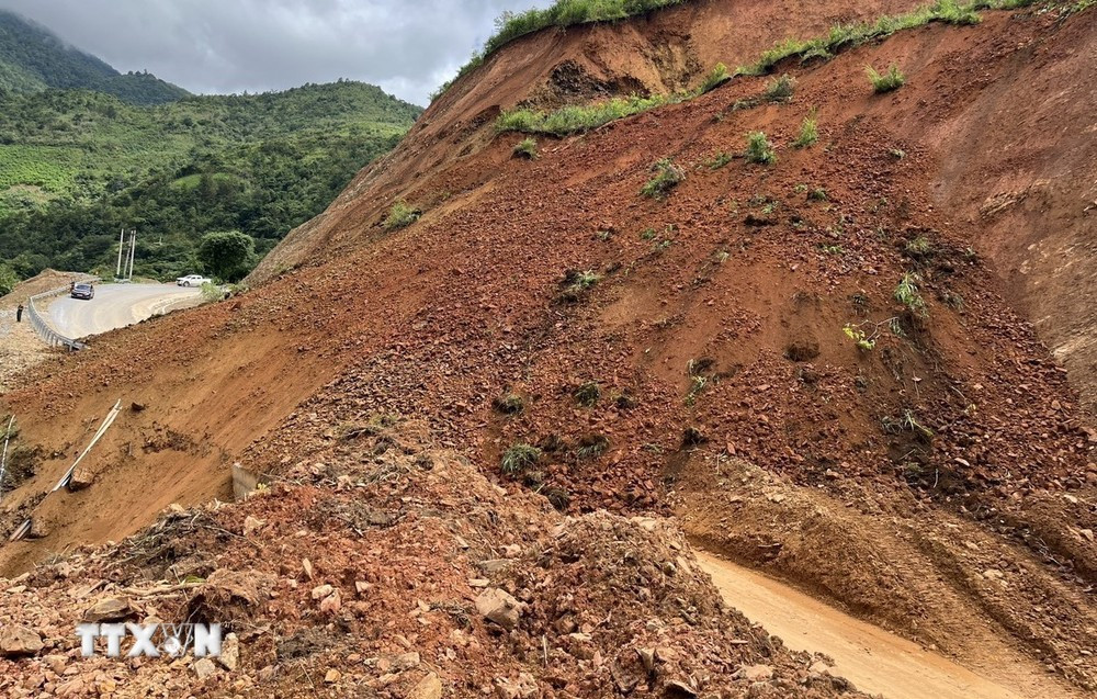
According to the National Center for Hydro-Meteorological Forecasting, from early morning of August 21 to early morning of August 23, the mountainous and midland areas of the North will continue to have moderate rain, heavy rain and thunderstorms, locally very heavy rain with common rainfall from 50-100mm, in some places over 230mm.
In addition, during the day and night of August 21, the Northern Delta and Thanh Hoa will have rain, moderate rain and scattered thunderstorms, locally heavy to very heavy rain with rainfall from 15-30mm, locally over 60mm. From August 23, heavy rain is likely to gradually decrease; the risk of natural disasters due to heavy rain, tornadoes, and lightning is level 1.
Experts warn of the possibility of tornadoes, lightning and strong gusts of wind during thunderstorms. In addition, heavy rains can cause flooding in low-lying areas; flash floods in small rivers and streams; and landslides on steep slopes.
Regarding landslide risk warning, on the night of August 20 and early morning of August 21, the mountainous and midland provinces of the North had moderate rain, heavy rain, and very heavy rain in some places such as: Hung Duc (Tuyen Quang) 136.8mm; Mo Vang 1 (Yen Bai) 135.8mm; It Ong (Son La) 83.6mm; Ban Lien (Lao Cai) 69.2mm; Nam Dan (Ha Giang) 51.8mm...
Soil moisture models show that some areas in the above provinces are close to saturation (over 85%) or have reached saturation.
On the morning of August 21, the above provinces continued to have rain with common accumulated rainfall such as: in Lai Chau, Dien Bien, Son La, Lao Cai provinces from 40-60mm, some places over 90mm; Ha Giang, Yen Bai, Tuyen Quang, Bac Kan, Phu Tho and Thai Nguyen provinces from 20-40mm, some places over 60mm.
People in the above areas need to be on guard against the risk of flash floods on small rivers and streams, and landslides on steep slopes in many districts. Warning of natural disaster risks due to flash floods, landslides, and land subsidence due to heavy rain or level 1 flow.
Flash floods and landslides can have very negative impacts on the environment, threaten people's lives; cause local traffic congestion, affect the movement of vehicles; destroy civil and economic works, causing damage to production and socio-economic activities.
Weather forecast for regions across the country on the day and night of August 21: Northwest region is cloudy, with moderate rain, heavy rain and thunderstorms, locally very heavy rain; light wind; thunderstorms are likely to have tornadoes, lightning and strong gusts. Lowest temperature 22-25 degrees Celsius, some places below 22 degrees Celsius. Highest temperature 29-32 degrees Celsius, some places above 32 degrees Celsius.
The Northeast region is cloudy with moderate rain, heavy rain and thunderstorms, locally very heavy rain; the plains and Thanh Hoa have rain, moderate rain and scattered thunderstorms, locally heavy to very heavy rain; light wind; in thunderstorms there is a possibility of tornadoes, lightning and strong gusts. The lowest temperature is from 24-27 degrees Celsius. The highest temperature is from 29-32 degrees Celsius, some places above 32 degrees Celsius.
Hanoi capital is cloudy, with rain, moderate rain and thunderstorms, locally heavy rain; light wind; in thunderstorms there is a possibility of tornadoes, lightning and strong gusts of wind. Lowest temperature 24-26 degrees Celsius. Highest temperature 30-32 degrees Celsius.
Provinces from Thanh Hoa to Thua Thien-Hue will be cloudy, sunny during the day, with some places experiencing severe heat; showers and thunderstorms in the evening and at night in some places; light winds; in thunderstorms there is a possibility of tornadoes, lightning and strong gusts of wind. The lowest temperature is 26-29 degrees Celsius. The highest temperature is 34-37 degrees Celsius, with some places above 37 degrees Celsius.
Provinces and cities from Da Nang to Binh Thuan will have clouds, hot and sunny days, some places will be very hot; showers and thunderstorms in the evening and at night. Southwest wind level 2-3; in thunderstorms there is a possibility of tornadoes, lightning and strong gusts. Lowest temperature 25-28 degrees Celsius. Highest temperature 34-37 degrees Celsius, some places will be over 37 degrees Celsius.
The Central Highlands region is cloudy, sunny during the day, scattered showers and thunderstorms in the late afternoon and evening, and scattered showers and thunderstorms at night. Southwest wind level 2-3; in thunderstorms there is a possibility of tornadoes, lightning and strong gusts of wind. Lowest temperature 21-24 degrees Celsius. Highest temperature 30-33 degrees Celsius.
The Southern region is cloudy, sunny during the day, scattered showers and thunderstorms in the late afternoon and evening, and scattered showers and thunderstorms at night. Southwest wind level 2-3; in thunderstorms, there is a possibility of tornadoes, lightning and strong gusts of wind. Lowest temperature 25-28 degrees Celsius. Highest temperature 32-35 degrees Celsius, some places above 35 degrees Celsius.
TB (according to VNA)
.jpg "Results of the 2024 Administrative Reform Index of departments, branches, sectors and district-level People's Committees in Hai Duong")
