


Submit a comment
Vietnam and international forecasting centers agree that when entering the East Sea, storm YAGI will move mainly in a westerly direction, with a tendency to increase in intensity, so it is necessary to prepare response scenarios.
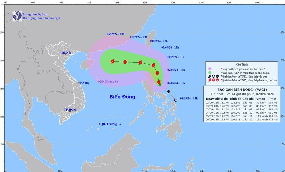
Commenting on storm YAGI, on the evening of September 2, Head of Weather Forecast Department, National Center for Hydro-Meteorological Forecasting Nguyen Van Huong said that it is likely that on the night of September 3, the storm will cross the 120th meridian and enter the East Sea.
When the storm moves into the East Sea, atmospheric conditions (wind, air pressure), ocean (sea water temperature in the East Sea area is 30-31 degrees Celsius) will create favorable conditions for the storm to strengthen and move westward.
Regarding the current developments of the storm, Mr. Nguyen Van Huong said that it is not yet possible to confirm whether storm YAGI will pass Hainan Island and move into the Gulf of Tonkin to directly affect the mainland of our country or not. However, under the impact of the storm's circulation, from September 3, the northeastern sea area of the North East Sea will have strong gusts of wind and big waves.
"These are only preliminary assessments of the development of storm Yagi, because when it passes the north of Luzon Island (Philippines), the storm's intensity and path will change due to the impact of terrain and large-scale currents," Mr. Nguyen Van Huong noted.
The National Center for Hydro-Meteorological Forecasting will continuously update the storm's developments. Local authorities and people need to regularly monitor forecast and warning information on the center's website at nchmf.gov.vn, provincial, municipal and regional Hydro-Meteorological Stations; at the same time, regularly update the latest information about the storm on the official mass media of the Central and local levels to proactively respond.
As of 1 p.m. on September 2, Vietnam and international forecasting centers agreed that when entering the East Sea, storm YAGI will move mainly in a westerly direction, with a tendency to increase in intensity.
Forecasts also predict that Typhoon YAGI will be strongest in the eastern part of Hainan Island (China). However, there are still significant differences such as Japan's forecast that the strongest intensity of the storm will reach level 13, gusting to level 17; China and Hong Kong (China) predict the strongest intensity of the storm will be level 15; the US predicts the strongest intensity of the storm will reach level 16, gusting above level 17.
According to the YAGI storm bulletin of the National Center for Hydro-Meteorological Forecasting, at 1 p.m., the center of the storm was located at about 16.1 degrees north latitude; 122.5 degrees east longitude, in the sea east of Luzon Island. The strongest wind near the center of the storm was level 8 (62-74 km/h), gusting to level 11. The storm moved northwest at a speed of about 20 km/h.
Due to the influence of the storm, from the afternoon of September 3, the northeastern sea area of the North East Sea will gradually increase in wind speed to level 6, near the eye of the storm will increase in wind speed to level 8, gusting to level 11, and the sea will be rough. From September 4-6, storm YAGI may reach a very strong storm level in the northeastern East Sea area, near the eye of the storm, the maximum wind speed may reach level 12, gusting to level 15.
In addition, in the next 24 hours, the eastern sea of the North East Sea will have waves 2-4m high. On September 4-6, the waves in the above area may increase to 5-7m, the sea will be rough and very dangerous for ships operating in this area.
Previously, on the evening of September 1, a tropical depression in the central region of the Philippines strengthened into a storm. The storm's international name is YAGI and it is the 11th storm active in the northwest Pacific region.
TH (according to VietnamPlus)