


.jpg "Invite you to read Hai Duong newspaper special issue")
.jpeg "People rush to complete real estate procedures before 'G hour'")


.jpg "Outstanding domestic and international events on April 25")

.jpg "Agree on proposal to exempt and support tuition fees for students")
.jpg "Woman in Bac Ninh illegally bought and sold invoices worth more than 6,000 billion VND")
.jpg "US President Donald Trump announced that Chinese President Xi Jinping had contacted")

.jpg "Noi Bai Airport is expected to welcome 108,000 passengers on the peak day of April 30.")

.jpg "Hai Duong Power conducts disaster prevention and incident response drills in 2025")

Submit a comment
Storm No. 8 is showing signs of weakening in the North East Sea. There are two storms east of the Philippines, one of which is likely to enter the East Sea and become storm No. 9 early next week.
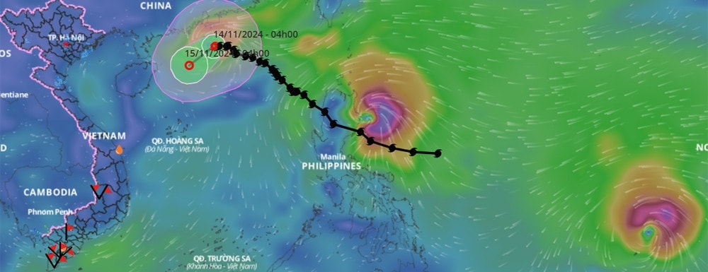
According to the National Center for Hydro-Meteorological Forecasting, at 7:00 a.m. this morning, November 14, the center of storm No. 8 Toraji was located in the northern waters of the North East Sea. The strongest wind near the center of the storm was level 8 (62-74 km/h), gusting to level 10. Moving west at a speed of about 5 km/h.
Thus, compared to yesterday, storm number 8 continues to show signs of weakening.
Experts say that in the next 24 hours, storm No. 8 will change direction to the southwest, move slowly and weaken into a tropical depression.
By 7am tomorrow morning (November 15), the center of the tropical depression in the northwest sea of the North East Sea will have reduced its intensity to level 6, gusting to level 8.
During the day and night of November 16, the tropical depression weakened from storm No. 8 and moved toward the northern waters of the Hoang Sa archipelago, continued to weaken into a low pressure area and gradually dissipated at sea, without affecting the mainland of our country.
Due to the influence of storm No. 8, the northern sea area of the North East Sea has strong winds of level 6, near the eye of the storm level 7-8, gusts of level 10, waves 2-3m high, near the eye of the storm 3-5m, rough seas. Ships operating in the above-mentioned dangerous areas are likely to be affected by storms, whirlwinds, strong winds and big waves.
In addition, in the east of the Philippines, there are strong storms Usagi and Manyi. Of these, storm Usagi is closer to the East Sea and appeared later, so it is numbered 25.
Experts say that this storm still has the potential to enter the East Sea, but the probability is not high. According to forecast models, the storm will move north of Luzon Island (Philippines) around November 14, then move towards Taiwan (China), encounter cold air and weaken.
Notably, off the coast of the Philippines, typhoon Manyi formed earlier (number 24) and according to current assessments, has a higher probability of entering the East Sea than typhoon Usagi, and could become typhoon number 9 in this year's typhoon season.
According to the US forecast model, Typhoon Manyi may reach super typhoon level. When it approaches Luzon Island, it may reach level 17, gusting to level 18. Around the beginning of next week (November 18), when it passes Luzon Island and enters the East Sea, it may still be strong at level 13, gusting to level 15-16.
However, meteorological experts say that in the coming time, cold air from the north will increase and move south, affecting the path and intensity of the storm, so it is necessary to monitor and update in the next bulletins.
Thus, this November, along with the existence of the previous storm Yinxing, there will be 4 storms simultaneously in the western Pacific Ocean. Vietnam alone, if it welcomes storm Manyi, will have 3 consecutive storms this month, 1 more than the average of many years.
The Japan Meteorological Agency said the occurrence of these four storms at the same time is rare, with the last occurrence being 73 years ago. One of the reasons is warmer ocean water, creating favorable conditions for storm formation.
TH (according to Vietnamnet)
.jpg "The violator has removed the surrounding wall and iron net around the Bac Hung Hai bridge pillar.")