


.png "Bão số 6 giật cấp 14, cách Hoàng Sa 230km")


")


.jpg "Kim Thanh reclaims more than 234 hectares of land to build an industrial park")


.jpg "Binh Giang's first quarter budget revenue reached nearly half of the province's annual target.")
.jpg "Early spring tea")

Submit a comment
At 4am this morning, storm number 6 (storm Trami) was at level 9-10, gusting to level 12, about 125km east-northeast of Da Nang. The Central region is forecast to have very heavy and prolonged rain.
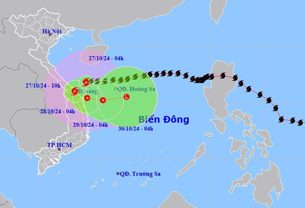
According to the latest storm information from the National Center for Hydro-Meteorological Forecasting, at 4:00 a.m. on October 27, the center of storm No. 6 was at about 16.8 degrees north latitude, 109.1 degrees east longitude, about 125km east-northeast of Da Nang.
The strongest wind near the storm center is level 9-10 (89-102km/h), gusting to level 12. The storm moves west at a speed of about 20km/h.
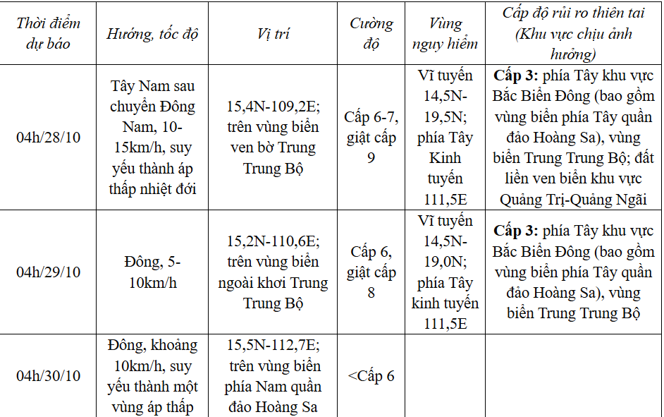
Today, October 27, storm No. 6 will enter the Quang Tri-Quang Nam provinces, then move out to sea and gradually weaken.
Currently, Bach Long Vi island area has strong winds of level 6-7, sometimes level 8, gusting to level 9; Con Co island, Ly Son has strong gusts of level 7.
In the western sea area of the North East Sea, there will be storms; in the southern Gulf of Tonkin and the sea area from Quang Tri to Quang Ngai, there will be showers and thunderstorms.
Forecast of impact of storm no. 6
The western sea area of the North East Sea has strong winds of level 6-7, sometimes level 8 on the morning of October 27, gusting to level 10, waves 2-4m high; rough seas.
The sea area of provinces from Quang Binh to Quang Ngai (including Con Co Island, Cu Lao Cham, Ly Son) has strong winds of level 6-7, the area near the storm's eye has winds of level 8-10, gusts of level 12, waves 3-5m high; very rough seas.
Storm surge in coastal areas: from the morning of October 27, coastal areas from Quang Binh to Quang Nam provinces are likely to experience storm surges of 0.4-0.6m high.
Ships operating in the above-mentioned dangerous areas (especially in the Hoang Sa island district), coastal areas from Quang Binh to Quang Ngai are likely to be affected by storms, whirlwinds, strong winds, and big waves.
High risk of landslides of sea dikes and embankments along the coast of provinces from Quang Tri to Quang Nam due to the impact of big waves and storm surges.
On land from Quang Binh to Quang Ngai, winds will gradually increase to level 6-7, gusting to level 8-9; near the storm center, winds will increase to level 8-9, gusting to level 11.
From early morning of October 27 to night of October 28, in the area from Quang Binh to Quang Nam, there will be heavy to very heavy rain with total rainfall ranging from 200-400mm, locally over 600mm. Warning of the risk of local heavy rain (>100mm/3 hours).
Ha Tinh, Quang Ngai, Binh Dinh and the Northern Central Highlands have heavy rain, locally very heavy rain with total rainfall ranging from 100-180mm, in some places over 250mm.
Storm Kong-rey strengthens
Tropical Storm Kong-rey is moving westward over the weekend, turning west-northwest on Monday (October 28) and northwest-northwest for the remainder of the forecast period, the Philippine Atmospheric, Geophysical and Astronomical Services Administration (PAGASA) said.
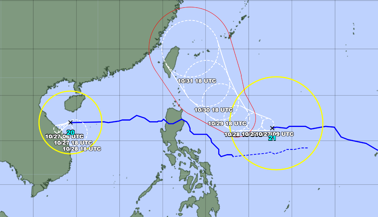
According to PAGASA, Typhoon Kong-rey is forecast to gradually strengthen and may reach severe tropical storm level on October 27 and typhoon level on October 28. Typhoon Kong-rey may hit Luzon Island (Philippines), approaching the East Sea.
VN (synthesis)


.jpg "Hai Duong's agricultural, forestry and fishery value increased by 7.51% in the first quarter.")