


.jpg "Before the thunderstorm, Hai Duong continues to be hot and sunny")


.jpg "Reading culture in the digital age")


.jpg "What to see in Hai Duong newspaper on April 21?")


-a9f705f0fc2bb442b889e7ca8cfb4e9f.jpg "Prime Minister directs early payment of pensions in May")


.jpg "Parishioners joyfully celebrate Easter at Hai Duong Church")


Submit a comment
According to the National Center for Hydro-Meteorological Forecasting, at 7:00 p.m. on October 18, the center of storm No. 5 was located at about 18 degrees North latitude; 108.7 degrees East longitude, in the sea southwest of Hainan Island (China).
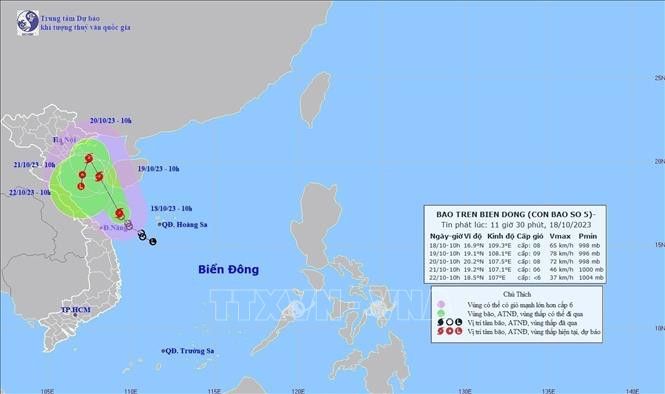
The strongest wind near the storm center is level 8 (62 - 74 km/h), gusting to level 10. The storm moves in a North-Northwest direction at a speed of about 10 km/h.
At 7:00 p.m. on October 19, the center of the storm was at about 20.3 degrees North latitude, 107.9 degrees East longitude, in the Gulf of Tonkin.
The strongest wind near the storm center is level 8 - 9, gusting to level 11. The storm moves in a North-Northwest direction at a speed of about 10 km/hour, with the potential to strengthen further.
Dangerous areas affected by the storm: North of latitude 16.5 degrees North, West of longitude 110.5 degrees East. The Gulf of Tonkin, the sea area from Quang Tri to Da Nang has a level 3 natural disaster risk level.
As of 7 p.m. on October 20, the eye of the storm was at approximately 20.1 degrees North latitude, 107.4 degrees East longitude, in the Gulf of Tonkin. The strongest wind near the eye of the storm was level 7, gusting to level 9.
The storm moved southwest at a speed of about 5 km/h and gradually weakened into a tropical depression.
Dangerous areas affected by the storm: North of latitude 18 degrees North, West of longitude 110.5 degrees East. The Gulf of Tonkin has a level 3 natural disaster risk.
At 7:00 p.m. on October 21, the eye of the storm was located at approximately 18.8 degrees North latitude, 107.2 degrees East longitude, in the Gulf of Tonkin. The strongest wind near the eye of the storm was below level 6.
The storm is moving south-southwest at a speed of 5 km/h and gradually weakening into a low pressure area. Dangerous areas at sea: north of latitude 17.5 degrees north, west of longitude 109 degrees east. The Gulf of Tonkin has a level 3 natural disaster risk.
Due to the impact of the storm, the sea area from Quang Tri to Da Nang and the Gulf of Tonkin (including Co To and Bach Long Vi island districts) has strong winds of level 6-7, the area near the storm center has strong winds of level 8-9, gusts of level 11, and very rough seas.
From early morning on October 20, coastal areas from Quang Ninh to Thai Binh have had winds gradually increasing to level 6, gusting to level 7-8.
All boats, anchorages, aquaculture areas, and sea dykes in this area are affected by strong winds and large waves.
On the night of October 18, the area from Quang Tri to Thua Thien - Hue will have moderate rain, heavy rain, and some places will have very heavy rain. From the night of October 19 to the night of October 21, coastal areas, the Southern region of the Northern Delta, the northeastern region of the North, and the North Central provinces are likely to have moderate rain, and some places will have heavy to very heavy rain.
According to VNA