


.jpg "Hai Duong welcomes heavy rain after nearly 8 months")

.jpeg "Hai Duong heavy rain and thunderstorms")
.jpg "Hai Duong requests to close 49 full landfills")


.jpg "Invite you to read Hai Duong newspaper special issue")
.jpeg "People rush to complete real estate procedures before 'G hour'")


.jpg "Outstanding domestic and international events on April 25")

.jpg "Agree on proposal to exempt and support tuition fees for students")
.jpg "Woman in Bac Ninh illegally bought and sold invoices worth more than 6,000 billion VND")
.jpg "US President Donald Trump announced that Chinese President Xi Jinping had contacted")

.jpg "Noi Bai Airport is expected to welcome 108,000 passengers on the peak day of April 30.")

.jpg "Hai Duong Power conducts disaster prevention and incident response drills in 2025")

Submit a comment
According to the National Center for Hydro-Meteorological Forecasting, last night, September 2, after moving into the southwestern coast of Guangdong province (China), storm No. 3 weakened into a tropical depression.
At 1:00 a.m. on September 3, the center of the tropical depression was located on the eastern coastal area of Leizhou Peninsula (China). The strongest wind near the center of the tropical depression was level 6-7 (39-61 km/h), gusting to level 9, moving in a West Southwest direction at a speed of about 10 km/h.
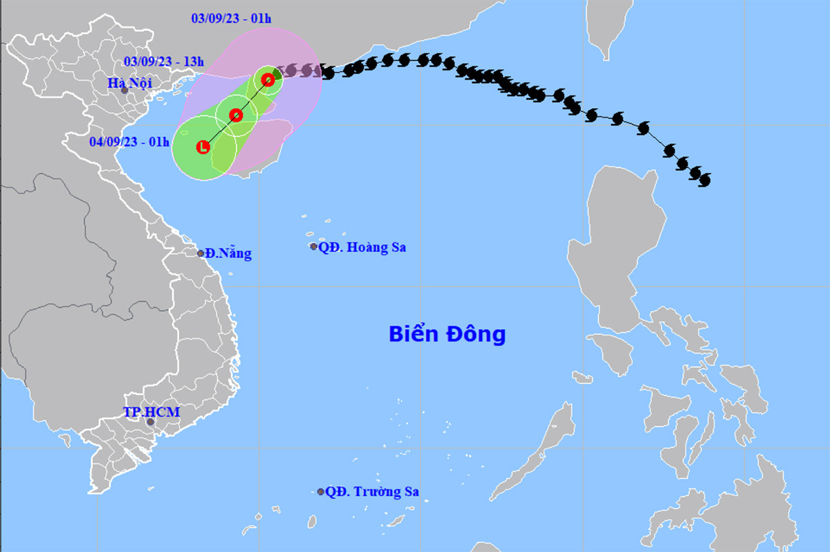
Storm No. 3 weakens into tropical depression
At around 1 p.m. the same day, the tropical depression in the sea northwest of Hainan Island (China) remained unchanged in direction, moving at a speed of 10-15 km. The strongest wind near the center of the depression was at level 6, gusting to level 8.
It is forecasted that by 1:00 a.m. on September 4, the tropical depression in the eastern sea of the Gulf of Tonkin will continue to move in a West-Southwest direction, traveling 10km per hour, and weaken into a low pressure area.
Impact of the tropical depression in the next 24 hours, the northwest sea area of the North East Sea on the morning of September 3 will still have strong winds of level 6-7, rough seas.
The eastern sea area of the Northern Gulf of Tonkin (including Bach Long Vi island district) has strong winds of level 6, gusts of level 8, rough seas, waves 1.5-2.5 m high. The northwest sea area of the Northern East Sea has waves 2-3 m high.
On the mainland of our country, last night, September 2, the Northern Central Highlands had moderate rain, heavy rain, some places had very heavy rain and thunderstorms. The Southern region had showers and thunderstorms, locally moderate rain.
Rainfall from 7pm on September 2 to 3am on September 3 was over 30mm in some places such as: Mang Canh (Kon Tum) 152.6mm, Buon Ma Thuot City (Dak Lak) 44.2mm, Se San Hydropower Plant (Gia Lai) 35.8mm, Dinh Trang Hoa (Lam Dong) 30.2mm...
From the afternoon of September 3 to 4, the Southern Central Highlands and the Southern region will have moderate to heavy rain, some places will have very heavy rain and scattered thunderstorms with rainfall from 30-70 mm, some places will have over 120 mm. The Northern Central Highlands will have showers and thunderstorms, locally heavy to very heavy rain with rainfall from 10-30 mm, some places will have over 70 mm.
Risk of flash floods, landslides in mountainous areas and flooding in low-lying areas. Beware of heavy rain in a short period of time causing flooding in urban areas. During thunderstorms, there is a possibility of tornadoes, lightning, hail and strong gusts of wind. Coastal areas in the Southwest need to be on guard against tornadoes and strong gusts of wind during thunderstorms.
According to VTC News
.jpg "The violator has removed the surrounding wall and iron net around the Bac Hung Hai bridge pillar.")