


.jpg "Hai Duong has showers and thunderstorms during the April 30 and May 1 holidays")

.jpg "Four more communes of Gia Loc district have their waste treated at the factory.")

.jpg "Seized a large amount of processed food without invoices or documents in Hai Duong City")

.jpg "Hai Duong handles 217 traffic violations in the first half day of the holiday")


.png "Podcast News April 30")


.jpg "Mother Buoi has husband and son who sacrificed for the Fatherland")

Submit a comment
Due to the impact of storm No. 2, from the night of July 22, the North is likely to have moderate rain, heavy rain and thunderstorms, locally very heavy rain. Total rainfall is commonly 100-200mm, in some places over 250mm.
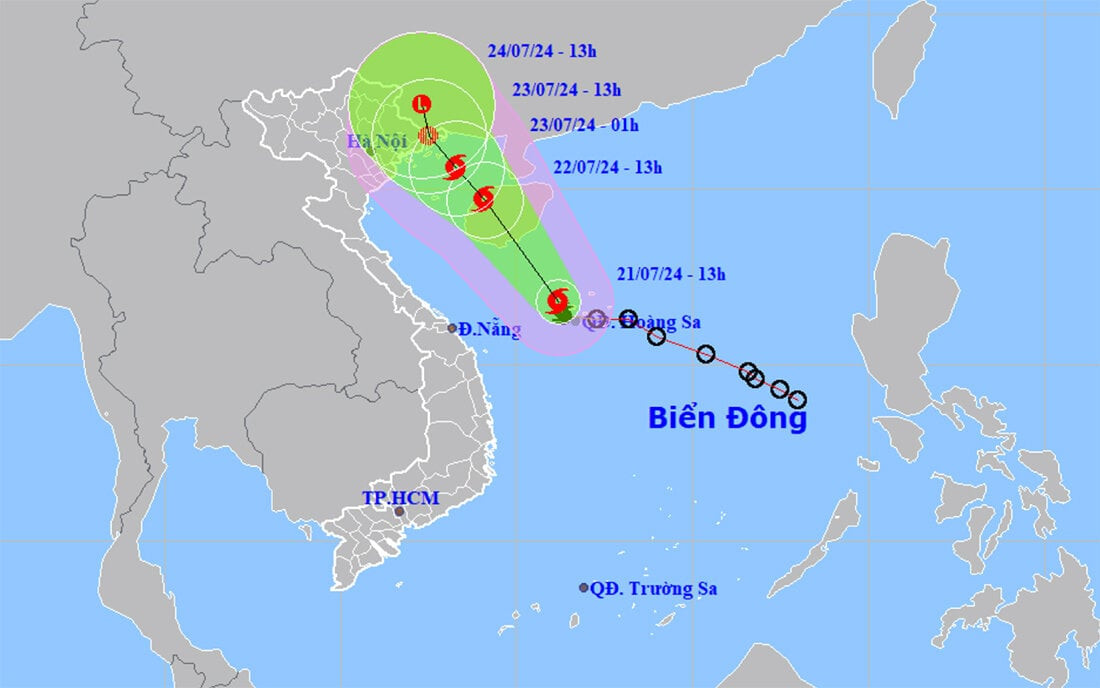
According to the National Center for Hydro-Meteorological Forecasting, at 1:00 p.m. on July 21, the center of storm No. 2 (storm Prapiroon) was located in the sea west of Hoang Sa archipelago. The strongest wind near the center of the storm was level 8 (62-74 km/h), gusting to level 10, moving west-northwest at a speed of 10-15 km/h.
In the next 24 hours, storm No. 2 in the northwest coastal area of Hainan Island (China) will move northwest at a speed of about 15 km/h. The strongest wind near the storm center is level 8, gusting to level 10.
Affected areas: Western sea area of the northern East Sea (including Hoang Sa archipelago), eastern sea area from Quang Tri to Quang Ngai, and Gulf of Tonkin.
Forecast by 13:00 on July 23, storm No. 2 on land in the Northeast region of the North, moving direction unchanged, speed about 10 km/h and entering the Gulf of Tonkin. The strongest wind near the storm is level 6-7, gusting to level 9. Affected area: Gulf of Tonkin.
At around 1:00 p.m. on July 24, storm No. 2 on the mainland south of Guangxi province (China) continued to move northwest at about 5-10 km/h and gradually weakened into a low pressure area.
Due to the impact of storm No. 2, from the night of July 22 to July 24, the North and Thanh Hoa are likely to have moderate rain, heavy rain and thunderstorms, with some places experiencing very heavy rain. Total rainfall in the Northeast is generally 100-200mm, with some places experiencing over 250mm; other places in the North and Thanh Hoa are 50-100mm, with some places experiencing over 150mm.
From the morning of July 22, the wind in the northern Gulf of Tonkin gradually increased to level 6-7, the area near the center of storm No. 2 had strong winds of level 8, gusting to level 10, and rough seas.
VN

