
.jpg "Giá sắn dây ở xã Thanh Lang (Thanh Hà) tăng")
.jpg "Thanh Hà chọn Đảng bộ xã Thanh Lang tổ chức đại hội điểm khối xã")


")

-d0772b57e88f948e139a9a67176fefdf.jpg "Forecast: Hai Duong is about to welcome the return of cold air")


.jpg "Kim Thanh reclaims more than 234 hectares of land to build an industrial park")


.jpg "Binh Giang's first quarter budget revenue reached nearly half of the province's annual target.")
.jpg "Early spring tea")
Submit a comment
Currently, the riverbank area corresponding to the dike section from K11+150 - K11+350 of the right dike of Rang River through Thanh Lang commune (Thanh Ha) is eroded.
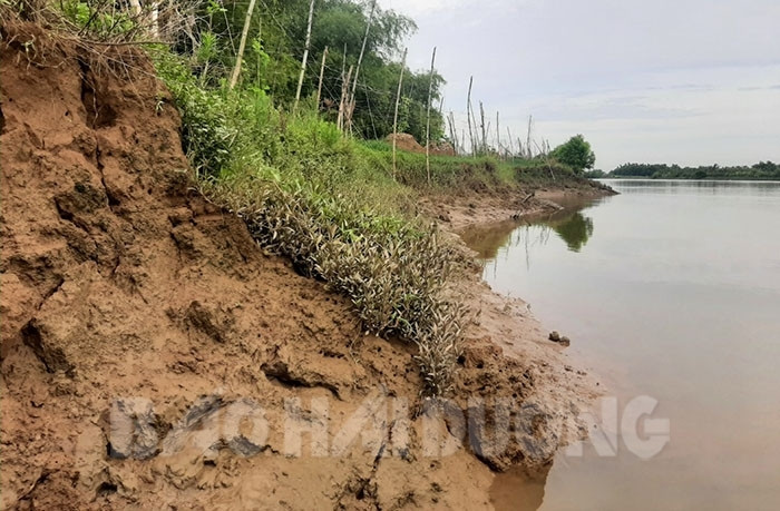
This riverbank is still likely to continue to erode, potentially posing a risk to the safety of the dike system.
The landslide area is located on the concave bank of the river, directly impacted by the main stream. This area has poor geological foundation, mainly sandy soil, so it is prone to landslides.
Before the flood season this year, this area had a landslide with a 90 m long landslide arc. In March 2021, this incident continued to have landslides expanding to both upstream and downstream with a total length of about 200 m, encroaching 1 - 2 m deep into the beach, the closest distance from the dike foot to the edge of the landslide is 20 - 22 m. Currently, this landslide arc is still at risk of further landslides, posing a potential risk to the safety of the dike structure.
The District Steering Committee for Natural Disaster Prevention and Search and Rescue has placed warning signs and closely monitored the landslide, developed a plan to handle the first hour; at the same time, requested the Provincial Steering Committee for Natural Disaster Prevention and Search and Rescue to invest funds to urgently handle the incident to ensure the safety of the dike system.
Khanh Hoa


.jpg "Hai Duong's agricultural, forestry and fishery value increased by 7.51% in the first quarter.")