

.jpg "Hải Dương đón không khí lạnh")


.jpg "26 earthquakes occurred in March at 'hot spots' in Kon Tum and Quang Nam")


.jpg "In the North, there are places with severe cold.")
.jpg "Forecast for the new week, Hai Duong welcomes increased cold air")


.jpeg "Hanoi has 189 more measles cases in the past week")


.jpg "5,000 Japanese audiences excited for the 'Brothers Overcoming a Thousand Thorns'")

.jpg "Domestic gold price continues to climb, surpassing 102 million VND per tael")


Submit a comment
It is forecasted that early next week, the North will welcome a new cold air mass, the mountainous areas will turn cold, and the Central region may experience widespread heavy rain.
On the afternoon of November 7, hydrometeorological experts said that around November 13-14, a new cold air mass will flow into our country, causing the temperature in the North to drop about 4 degrees Celsius compared to the previous day.
According to the National Center for Hydro-Meteorological Forecasting, on November 12-13, the North is likely to have scattered showers and thunderstorms, with moderate to heavy rain. In particular, the Northeast region will have scattered rain on November 11. From around November 13, this area is likely to turn cold, and mountainous areas will turn cold.

The North is about to welcome a new cold air wave
In Hanoi, on November 13-14, the highest temperature in the capital is forecast to be around 24 degrees Celsius, down 5 degrees Celsius compared to the previous day, with cloudy skies.
In the next 3 days, the highest temperature in Hanoi increased by about 2-3 degrees Celsius, the weather was cloudy, no rain.
According to the meteorological agency, the Central region is likely to experience widespread heavy rain from November 13 to 17. The weather in the North Central region may turn cold from around November 13.
In the late afternoon and evening of November 9 to November 17, the South will have scattered showers and thunderstorms, with some areas having moderate to heavy rain.
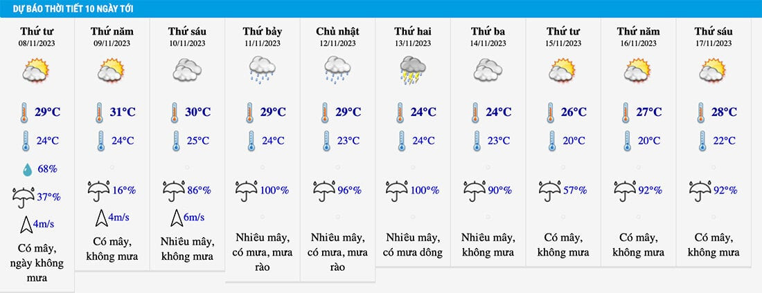
Weather forecastHanoi 10 days to go
Before the widespread heavy rain, many places in the Central region had heavy to very heavy rain. Specifically, today, this area had showers and thunderstorms, locally heavy to very heavy rain.
Rainfall from 7am to 3pm on November 7 was over 100mm in some places such as: Son Kim 2 (Ha Tinh) 157mm, Ho Hoa Trung (Da Nang) 132.2mm, Dai Hiep (Quang Nam) 111.6mm...
From the evening of November 7 to the morning of November 8, Ha Tinh to Binh Thuan will have scattered showers and thunderstorms, locally moderate rain, heavy rain with rainfall of 20-40mm, some places over 80mm. In particular, Thua Thien Hue to Quang Nam will have moderate rain, heavy rain, some places very heavy rain with rainfall of 30-50mm, some places over 100mm.
From the evening of November 7 to November 8, the South will have scattered showers and thunderstorms, locally moderate rain, heavy rain with rainfall of 15-30mm, some places over 50mm, rain concentrated in the afternoon and evening.
During thunderstorms, there is a possibility of tornadoes, lightning, hail and strong gusts of wind, flash floods on small rivers and streams, landslides on steep slopes. Heavy rain can cause flooding in low-lying areas.
At sea, on the night of November 7 and November 8, the western sea area of the North and Central East Sea (including the waters of the Hoang Sa archipelago), the southern East Sea (including the waters of the Truong Sa archipelago), the sea area from Quang Tri to Ca Mau, Ca Mau to Kien Giang and the Gulf of Thailand will have showers and thunderstorms. During thunderstorms, beware of tornadoes and strong gusts of wind of level 6-7.
In addition, on the night of November 7 and November 8, the northeastern sea area of the North East Sea will have strong northeast to east winds at level 5, sometimes level 6, gusting to level 7, rough seas, and waves 2-3m high.
According to VTC News

.jpg "Hai Duong approved 50 people to quit their jobs according to Decree 178 and 67")
