

.jpg "Bắc Bộ có nơi rét đậm, rét hại")

.jpg "Bắc Bộ sáng có mưa phùn và sương mù rải rác")

.jpg "Cụm thi đua Sở Tư pháp, Cục Thi hành án dân sự các tỉnh đồng bằng Bắc Bộ đoàn kết, hoàn thành tốt nhiệm vụ")
.jpg "Tuyên bố về đường cơ sở để tính chiều rộng lãnh hải Việt Nam trong Vịnh Bắc Bộ")

.jpg "Bắc Bộ duy trì mưa phùn, nồm ẩm đến bao giờ?")


")


.jpg "Kim Thanh reclaims more than 234 hectares of land to build an industrial park")


.jpg "Binh Giang's first quarter budget revenue reached nearly half of the province's annual target.")
.jpg "Early spring tea")

Submit a comment
People should closely monitor warnings on the media to take measures to prevent damage caused by storms and tornadoes.
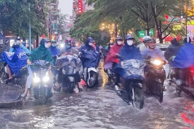
Flooding in Hanoi causes some vehicles to move slowly or stop temporarily.
According to the National Center for Hydro-Meteorological Forecasting, from August 2-3, the Northern and North Central regions will have moderate rain, heavy rain, and locally very heavy rain with common rainfall from 60-120mm, in some places over 200mm.
The Central Highlands and the South have moderate rain, heavy rain, and locally very heavy rain with common rainfall from 50-100mm, in some places over 150mm (rain concentrated in the afternoon and night).
From 7am on August 2 to 7am on August 4, the North and North Central regions will have rain from 60-120mm, with some places over 200mm. The Central Highlands and the South will have rain from 50-100mm, with some places over 150mm.
In Hanoi alone, from 4 to 8 a.m. on August 2, convective clouds will continue to develop and expand, causing showers and thunderstorms, with the possibility of expanding to other inner-city districts of Hanoi such as Ba Dinh, Tay Ho, Hoan Kiem, Hai Ba Trung, Long Bien... in thunderstorms, there is a possibility of tornadoes, lightning, hail and strong gusts of wind. The risk level of natural disasters due to tornadoes, lightning and hail is level 1.
In addition, on the day and night of August 2, the area from Quang Binh to Thua Thien-Hue will have scattered showers and thunderstorms, locally heavy rain with rainfall of 10-30mm, some places over 50mm (thunderstorms concentrated in the afternoon and night).
Warning, from August 4, moderate and heavy rain in the Northern and North Central regions, Central Highlands and Southern regions will gradually decrease. The risk level of natural disasters due to heavy rain, tornadoes, lightning and hail is level 1.
The above areas are at risk of flash floods, landslides in mountainous areas and flooding in low-lying areas. Heavy rain in a short period of time can cause flooding in urban areas, and thunderstorms can cause tornadoes, lightning, and strong gusts of wind.
Weather forecast for the day and night of August 2: The Northwest region will have moderate to heavy rain, some places will have very heavy rain and scattered thunderstorms, with the possibility of tornadoes, lightning, hail and strong gusts of wind. The lowest temperature is 23-26 degrees Celsius, some places below 23 degrees Celsius; the highest is 29-32 degrees Celsius, some places above 32 degrees Celsius.
The Northeast region has moderate rain, heavy rain, some places have very heavy rain and scattered thunderstorms, with the possibility of tornadoes, lightning, hail and strong gusts of wind. Southwest to South wind level 2-3. Lowest temperature 23-26 degrees Celsius, some places below 23 degrees Celsius, highest 30-33 degrees Celsius.
Hanoi capital has moderate rain, heavy rain and thunderstorms, with the possibility of tornadoes, lightning, hail and strong gusts of wind. The lowest temperature is 24-26 degrees Celsius, the highest is 30-33 degrees Celsius.
From Thanh Hoa to Thua Thien-Hue, the North has moderate rain, heavy rain, some places have very heavy rain and scattered thunderstorms; the South has scattered showers and thunderstorms during the day, scattered showers and thunderstorms in the evening and at night, locally heavy rain, with the possibility of tornadoes, lightning, hail and strong gusts of wind during thunderstorms. Southwest wind level 2-3. Lowest temperature 24-27 degrees Celsius, highest 29-32 degrees Celsius, some places over 32 degrees Celsius.
Provinces and cities from Da Nang to Binh Thuan will have sunny days, with scattered showers and thunderstorms in the late afternoon and at night. There is a possibility of tornadoes, lightning and strong gusts of wind during thunderstorms. Southwesterly winds level 2-3. Lowest temperature 25-28 degrees Celsius, highest 31-34 degrees Celsius.
In the afternoon and at night, the Central Highlands and the South will have moderate rain, heavy rain, very heavy rain in some places and scattered thunderstorms, with the possibility of tornadoes, lightning and strong gusts of wind. Southwest wind level 2-3. The lowest temperature in the Central Highlands is 20-23 degrees Celsius, the highest is 26-29 degrees Celsius. The lowest temperature in the South is 23-26 degrees Celsius, the highest is 30-33 degrees Celsius, some places are over 33 degrees Celsius.
Faced with the above dangerous weather conditions, Head of the Weather Forecast Department, National Center for Hydro-Meteorological Forecasting Nguyen Van Huong warned that thunderstorms, tornadoes, lightning, and strong gusts of wind pose a serious risk to people's lives and property. Tornadoes often occur with strong thunderstorms. When there are warnings of thunderstorms, people should take shelter in safe places in solidly built structures.
People should closely monitor warnings on the media to take measures to prevent damage caused by storms and tornadoes.
According to VNA


.jpg "Hai Duong's agricultural, forestry and fishery value increased by 7.51% in the first quarter.")