


")

-d0772b57e88f948e139a9a67176fefdf.jpg "Forecast: Hai Duong is about to welcome the return of cold air")


.jpg "Kim Thanh reclaims more than 234 hectares of land to build an industrial park")


.jpg "Binh Giang's first quarter budget revenue reached nearly half of the province's annual target.")
.jpg "Early spring tea")
Submit a comment
On March 19, the Northern and North Central regions will have scattered showers and thunderstorms, locally heavy rain with rainfall from 15-30mm, some places over 70mm, the weather will turn cold.
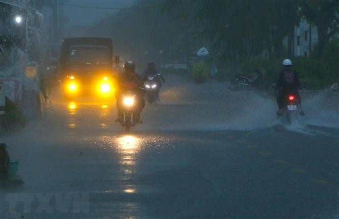
According to the National Center for Hydro-Meteorological Forecasting, convective clouds are developing and causing rain in many areas of Hanoi city.
Thunderstorms may contain tornadoes, lightning, hail and strong winds.
On March 19, the Northern and North Central regions will have scattered showers and thunderstorms; locally heavy rain with rainfall ranging from 15-30mm, some places over 70mm. From the night of March 19, rain will tend to decrease. Thunderstorms may include tornadoes, lightning, hail and strong gusts of wind.
Localized heavy rains are likely to cause flash floods on small rivers and streams, landslides on steep slopes and waterlogging in low-lying areas.
Cold air has affected some places in the northern mountainous region. On March 19, this cold air mass will affect other places in the North and North Central regions, then affect some places in the Central Central region. The wind will change to the Northeast at level 2-3 inland, level 4-5 in coastal areas.
From March 19, the weather in the North and North Central regions will turn cold. During this cold air mass, the lowest temperature in the North will generally be from 15-18 degrees Celsius, in mountainous areas from 12-15 degrees Celsius, in high mountainous areas below 10 degrees Celsius; in the North Central region, the lowest temperature will be from 16-19 degrees Celsius.
In the Gulf of Tonkin, the northeast wind gradually increases to level 6, sometimes level 7, gusting to level 8; the sea is rough, with waves 2-3m high. In the northern East Sea (including the Hoang Sa sea area), the northeast wind gradually increases to level 6, sometimes level 7, gusting to level 8-9; the sea is rough, with waves 2-4m high. In the northern and north central regions, there are scattered showers and thunderstorms, with locally heavy rain.
From the afternoon of March 19, the area from Quang Binh to Phu Yen will have rain, showers and thunderstorms in some places; thunderstorms may include tornadoes, lightning, hail and strong gusts of wind. Thunderstorms accompanied by tornadoes, lightning, hail and strong gusts of wind can affect agricultural production, cause trees to fall, damage houses, traffic works and infrastructure.
Localized heavy rains may cause flooding in low-lying areas, flash floods in small rivers and streams, and landslides on steep slopes. Strong winds and large waves at sea may affect the operation of ships and other activities.
On the day and night of March 19, the Northwest will be cloudy with scattered showers and thunderstorms during the day, with heavy rain in some places; rain in some places at night. Thunderstorms may include tornadoes, lightning, hail and strong gusts of wind. The weather will turn cold.
Lowest temperature from 16-19 degrees Celsius, some places below 16 degrees Celsius. Highest temperature from 20-23 degrees Celsius; in the Northwest region 23-26 degrees Celsius.
Northeast region is cloudy, with scattered showers and thunderstorms during the day, locally heavy rain. Northeast wind level 2-3, coastal areas level 4-5. Thunderstorms are likely to cause tornadoes, lightning, hail and strong gusts of wind. The weather turns cold.
The lowest temperature is from 15-18 degrees Celsius, in mountainous areas from 13-15 degrees Celsius, in some places below 11 degrees Celsius. The highest temperature is from 19-21 degrees Celsius, in some places below 19 degrees Celsius.
Hanoi capital is cloudy, with scattered showers and thunderstorms during the day, locally heavy rain; some rain at night. Northeast wind level 2-3. The weather turns cold. Lowest temperature from 16-18 degrees Celsius. Highest temperature from 19-21 degrees Celsius.
Provinces and cities from Thanh Hoa to Thua Thien-Hue are cloudy, with showers and scattered thunderstorms in the North during the day, locally heavy rain, and scattered rain at night. In the South, there will be rain in some places in the morning, with scattered fog and light fog in the early morning; in the afternoon and at night, there will be rain, showers and thunderstorms in some places.
North to Northwest wind level 2-3, coastal areas level 4-5. In thunderstorms, there is a possibility of tornadoes, lightning, hail and strong gusts of wind. In the North, the weather turns cold; in the South, the morning and night are cold.
The lowest temperature in the North is from 16-19 degrees Celsius, in the South is from 20-22 degrees Celsius. The highest temperature in the North is from 20-23 degrees Celsius, in the South is from 24-27 degrees Celsius.
From Da Nang to Binh Thuan, it is cloudy. In the North, there will be some rain in the morning, rain in the afternoon and at night, showers and thunderstorms in some places. In the South, it will be sunny during the day, with some rain at night. Northeast wind level 2-3.
The lowest temperature is from 21-24 degrees Celsius, in the South some places are above 24 degrees Celsius. The highest temperature in the North is from 28-31 degrees Celsius, in the South is from 31-33 degrees Celsius.
The Central Highlands region is cloudy, sunny during the day, no rain at night, sunny during the day. East to Northeast wind level 2-3. Lowest temperature from 18-21 degrees Celsius. Highest temperature from 31-34 degrees Celsius, some places above 34 degrees Celsius.
The South is cloudy, sunny during the day, some places are hot, especially in the East; no rain at night. Northeast to East wind level 2-3. Lowest temperature from 23-26 degrees Celsius. Highest temperature from 32-35 degrees Celsius; especially in the East 35-37 degrees Celsius.
TB (according to VNA)


.jpg "Hai Duong's agricultural, forestry and fishery value increased by 7.51% in the first quarter.")