


.jpg "Reading culture in the digital age")


.jpg "What to see in Hai Duong newspaper on April 21?")


-a9f705f0fc2bb442b889e7ca8cfb4e9f.jpg "Prime Minister directs early payment of pensions in May")


.jpg "Parishioners joyfully celebrate Easter at Hai Duong Church")


Submit a comment
It is forecasted that this afternoon and night, September 3, storm Yagi will enter the East Sea, becoming storm number 3 in 2024. The storm is likely to reach very strong level in the next 1-3 days.
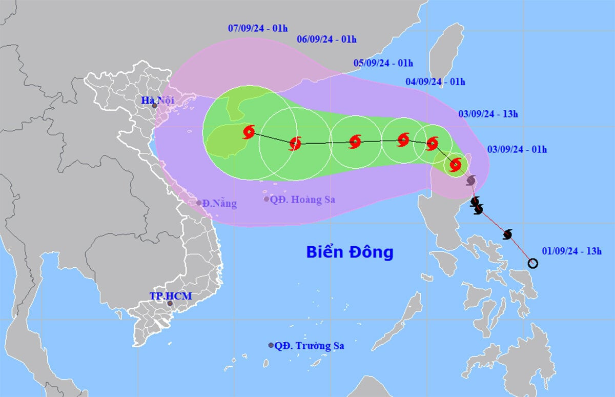
The National Center for Hydro-Meteorological Forecasting said that at 1:00 a.m. on September 3, the center of storm Yagi was at about 18.0 degrees North latitude; 121.5 degrees East longitude, in the northern area of Luzon Island (Philippines). The strongest wind near the center of the storm was level 8 (62-74 km/h), gusting to level 11, moving in a North-Northwest direction, about 20 km/h.
It is forecasted that in the afternoon and evening of the same day, Typhoon Yagi will enter the East Sea, becoming the third typhoon of 2024. From September 4-6, the typhoon is likely to reach very strong level in the Northeast of the East Sea, with maximum winds reaching level 12-13, gusting to level 16 near the center of the storm.
Specifically, in the next 24 hours, the storm will move in a West-Northwest direction at a speed of about 20 km/h, about 880 km east of Hainan Island (China) and move into the East Sea. The strongest wind near the storm center is level 9, gusting to level 12. Affected area: Northeast of the North East Sea.
At around 1am on September 5, storm No. 3 moved west at about 10km per hour, about 590km east of Hainan Island (China). The strongest wind near the storm center was level 11, gusting to level 14. Affected area: East of the North East Sea.
At 1:00 a.m. on September 6, the storm continued to move west at a speed of about 10 km/h, about 240 km east of Hainan Island (China). The strongest wind near the storm center was level 13, gusting to level 16. Affected area: North of the North East Sea.
From the next 72 to 120 hours, the storm will move mainly to the West, traveling 10km per hour, with the possibility of increasing in intensity.
Impact of storm Yagi, from noon and afternoon of September 3, the northeastern sea of the North East Sea area will gradually increase to level 6, near the storm center will increase to level 8, gusting above level 11, rough seas.
In the next 24 hours, the eastern sea of the North East Sea will have waves 2-4m high, near the storm center 3-5m, then (from September 4-6) it may increase to 5-7m. The sea will be very rough, very dangerous for ships.
TB (according to VTC)