


.jpg "Hai Duong took 33 samples of medicine, milk and functional foods for quality testing.")
.jpg "Be cautious about 'surfing' real estate before merging Hai Duong and Hai Phong")


.jpg "Thai Tan village (Nam Sach) is green from house to alley")


.jpg "Number of newly established enterprises in Hai Duong increased by 21.3%")


Submit a comment
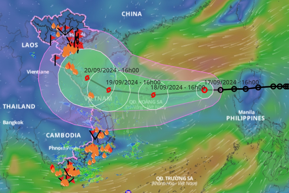
The area from Quang Binh to Quang Ngai in the next 24-48 hours will have gradually stronger winds following the development of the tropical depression that will later strengthen into storm No. 4 moving in; on land, be on guard for convective thunderstorms.

Regarding the tropical depression in the East Sea, after the possibility of strengthening into a storm, this afternoon, September 17, Mr. Nguyen Van Huong, Head of Weather Forecast Department, National Center for Hydro-Meteorological Forecasting shared updated information until 5:00 p.m.
Accordingly, this morning the tropical depression crossed the Lu Dong island area (Philippines) and entered the eastern area of the East Sea.
"We assess that in the next 24 hours, when moving to the eastern area of the Hoang Sa archipelago, the tropical depression is likely to strengthen into a storm. After that, the storm will move in a West-Northwest direction, causing strong winds of level 6 and level 7 in the northern East Sea as well as the waters of the Hoang Sa archipelago, with winds of level 8 near the storm's center.
"The area from Quang Binh to Quang Ngai in the next 24-48 hours will have gradually stronger winds following the development of the tropical depression that will later strengthen into a storm moving in," Mr. Huong emphasized.
Mr. Huong also commented that the tropical depression after strengthening into a storm, the probability of moving into the area from Thanh Hoa to Quang Ngai is about 70%; another scenario with a lower probability, is entering the northern area of the Gulf of Tonkin or the southern part of the Central region, about 15%.
With scenario 1, the area directly affected is the area from Thanh Hoa to Quang Ngai sea.
It is forecasted that in the next 24-48 hours, the sea area from Quang Binh to Quang Ngai will have strong winds, from tomorrow onwards the central sea area will have widespread rain.
"On land, from noon tomorrow afternoon, the North and Central Central regions will have moderate rain and from tomorrow night, heavy rain over a wide area, lasting until September 21," Mr. Huong noted.
In addition, Mr. Huong also said that under the impact of the tropical depression circulation that will strengthen into a storm, the sea area of the North East Sea and the Hoang Sa archipelago will be directly affected by the storm circulation. After that, the sea area from Thanh Hoa to Thua Thien Hue, the sea area of Da Nang, Quang Nam, Quang Ngai is also the area directly affected by the circulation of storm No. 4, which is likely to strengthen.
"In this area, boats need to anchor in shelters; aquaculture areas, especially in Thua Thien Hue province, need to pay close attention. At the same time, the situation of landslides on coastal dykes and embankments, need to pay attention to the dykes under construction to ensure the safety of the dykes and dams. Need to prevent flooding in low-lying coastal areas.
On land, be on guard against convective thunderstorms before the storm moves in, especially when there are strong thunderstorms, resulting in fallen trees and the possibility of metal roofs and advertising signs being blown into the air; be aware of flooding in urban areas.
In addition, the midland mountainous areas in the Northern and Central Central provinces from the night of September 18 to the end of September 21 and 22 are at risk of flash floods and landslides, and the lesson in the Northern region is a very important lesson to note.
TH (according to Vietnamnet)
