


.jpg "Reading culture in the digital age")


.jpg "What to see in Hai Duong newspaper on April 21?")


-a9f705f0fc2bb442b889e7ca8cfb4e9f.jpg "Prime Minister directs early payment of pensions in May")


.jpg "Parishioners joyfully celebrate Easter at Hai Duong Church")


Submit a comment
Storm No. 3 is moving in a West Northwest direction, gusting at level 12, forecast to continue to increase in intensity, with rough seas.
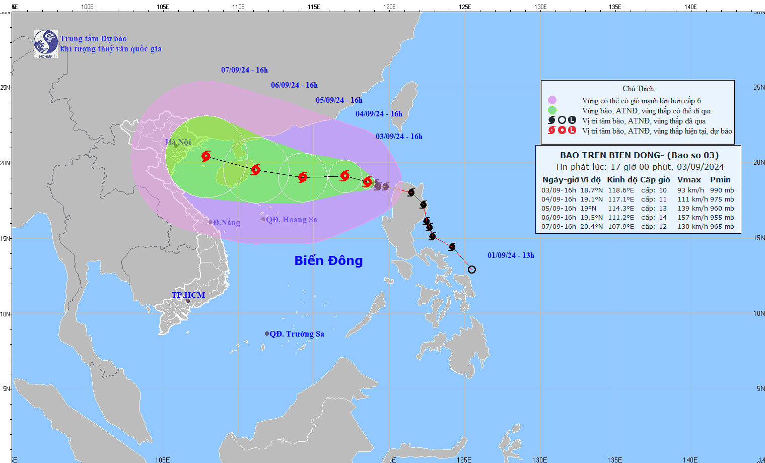
According to the National Center for Hydro-Meteorological Forecasting, storm No. 3 (Yagi) is one of the strongest storms in 2024 operating in the East Sea.
This storm is forecast to make landfall directly in the Northern provinces with very strong intensity. In the past 8 years, no strong storm has made landfall directly in the area since storm No. 1 (Mirinae) in 2016. The provinces that need special attention are Hai Phong, Thai Binh, Nam Dinh, Ha Nam, Ninh Binh and surrounding areas.
At 4:00 p.m. on September 3, the center of the storm was located at approximately 18.7 degrees North latitude; 118.6 degrees East longitude, in the eastern sea area of the North East Sea. The strongest wind near the center of the storm was level 10 (89 - 102 km/h), gusting to level 12, moving in the West Northwest direction, at approximately 15 km/h.
Forecast until 4:00 p.m. on September 4, the storm is moving in the West Northwest direction, speed about 10km/h, storm location at 19.1N-117.1E, about 700km east of Hainan Island (China), storm intensity level 11, gust level 13, dangerous area North of latitude 17.0N; East of longitude 115.0E, natural disaster risk level 3, affected area East of the North East Sea.
At 4:00 p.m. on September 5, the storm moved westward at a speed of 10-15 km/h, located at 19.0N-114.3E; approximately 390km east of Hainan Island (China), with a storm intensity of level 13, gusts of level 16, a dangerous area north of latitude 17.0N; 112.0E - 119.0E, a natural disaster risk level 3, and an affected area north of the North East Sea.
At 4:00 p.m. on September 6, the storm moved in the West-Northwest direction, 10-15km/hour, storm intensity level 14, gust level 17, dangerous area north of latitude 17.0N; 109.5E -116.5E, natural disaster risk level 4, affected area north of the North East Sea region.
From the next 72 to 120 hours, the storm will move mainly in the West Northwest direction, traveling 10-15km per hour, with little change in intensity, then gradually decreasing.
The eastern sea area of the North East Sea has strong winds of level 8-9, the area near the eye of the storm has winds of level 10-11, gusting to level 13; the sea is very rough. From the night of September 4-6, storm No. 3 can reach very strong storm level in the northern sea area of the North East Sea, strong winds can reach level 14, gusting to level 17 near the eye of the storm.
In the next 24 hours, the eastern sea of the North East Sea will have waves 2-4 m high, and 3-5 m near the storm center. From the night of September 4-6, they may gradually increase to 7-9 m. The sea will be rough. Ships operating in the above-mentioned dangerous areas are likely to be affected by strong winds and large waves.