


.jpg "Hai Duong is hot before thunderstorms")
.jpg "Dark clouds gather in many places in Hai Duong, beware of thunderstorms and hail")


.jpg "Hai Duong took 33 samples of medicine, milk and functional foods for quality testing.")
.jpg "Be cautious about 'surfing' real estate before merging Hai Duong and Hai Phong")


.jpg "Thai Tan village (Nam Sach) is green from house to alley")


.jpg "Number of newly established enterprises in Hai Duong increased by 21.3%")


Submit a comment
Storm No. 3 is currently in the eastern sea of the North East Sea, about 680km east of Hainan Island (China). The storm is forecast to intensify and move quickly towards the Gulf of Tonkin.
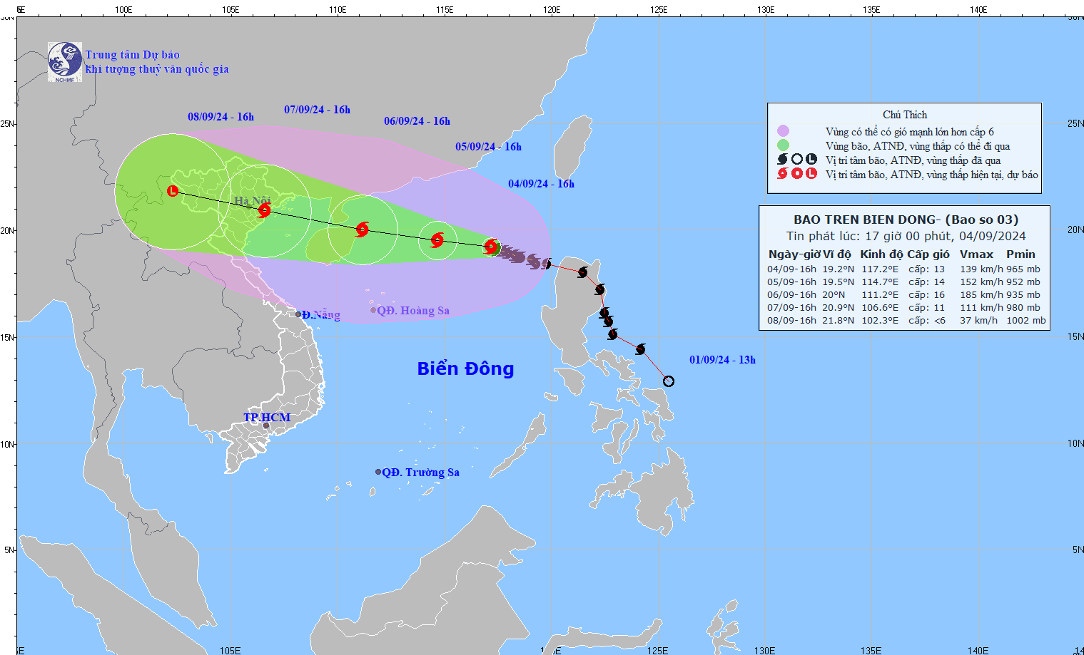
According to the National Center for Hydro-Meteorological Forecasting, at 4:00 p.m. on September 4, the center of the storm was located at approximately 19.2 degrees North latitude; 117.2 degrees East longitude, in the eastern sea area of the North East Sea, approximately 680 km east of Hainan Island (China). The strongest wind near the center of the storm was level 12 - 13 (118 - 149 km/h), gusting to level 16, moving in a West Northwest direction, at a speed of 5 - 10 km/h.
Forecast until 4:00 p.m. on September 5, the storm is moving in the West-Northwest direction, speed of about 10km/h, storm location at 19.5N-114.7E; about 400km east of Hainan Island (China), storm intensity level 14, gust level 17, natural disaster risk level 4, affected area is the North of the North East Sea.
At 4:00 p.m. on September 6, the storm moved in the West-Northwest direction, at a speed of about 15km/h, the storm was located at 20.0N-111.2E; in the sea northeast of Hainan Island (China), the storm intensity was level 15-16, gusting over level 17, the dangerous area was north of latitude 15.5N; longitude 108.0E - 117.0E, natural disaster risk level 4, the affected area was north of the North East Sea.
At 4:00 p.m. on September 7, the storm moved in the West-Northwest direction, at a speed of 15-20km/h, entering the Gulf of Tonkin, the storm was located at 20.9N-106.6E; on land in the Northeast region, the storm intensity was level 10-11, gusting to level 13, the dangerous area was north of latitude 15.5N; west of longitude 113.0E, the natural disaster risk level was level 3, the affected area was northwest of the North East Sea, the Gulf of Tonkin.
From the next 72 to 120 hours, the storm will move mainly in the West Northwest direction, traveling 15-20km per hour, and its intensity will continue to decrease.
The North East Sea area has strong winds of level 9-11, the area near the storm's eye has winds of level 12-14, gusting to level 17; the sea is very rough. From September 5-6, storm No. 3 continues to increase in intensity, possibly reaching 15-16, gusting to level 17 in the northern sea area of the North East Sea.
In the next 24 hours, the sea area of the North East Sea will have waves 5-7m high, near the storm center 7-10m. From September 6, they may gradually increase to 10-12m. The sea will be rough. Ships operating in the above-mentioned dangerous areas are likely to be affected by strong winds and large waves.

