


.jpg "Áp thấp nhiệt đới hình thành trên Biển Đông")


.jpg "Hai Duong has showers and thunderstorms during the April 30 and May 1 holidays")

.jpg "Four more communes of Gia Loc district have their waste treated at the factory.")

.jpg "Seized a large amount of processed food without invoices or documents in Hai Duong City")

.jpg "Hai Duong handles 217 traffic violations in the first half day of the holiday")


.png "Podcast News April 30")


.jpg "Mother Buoi has husband and son who sacrificed for the Fatherland")

Submit a comment
According to Deputy Director of the National Center for Hydro-Meteorological Forecasting Hoang Phuc Lam, when moving south, storm No. 10 will weaken into a tropical depression, with little chance of affecting mainland Vietnam.
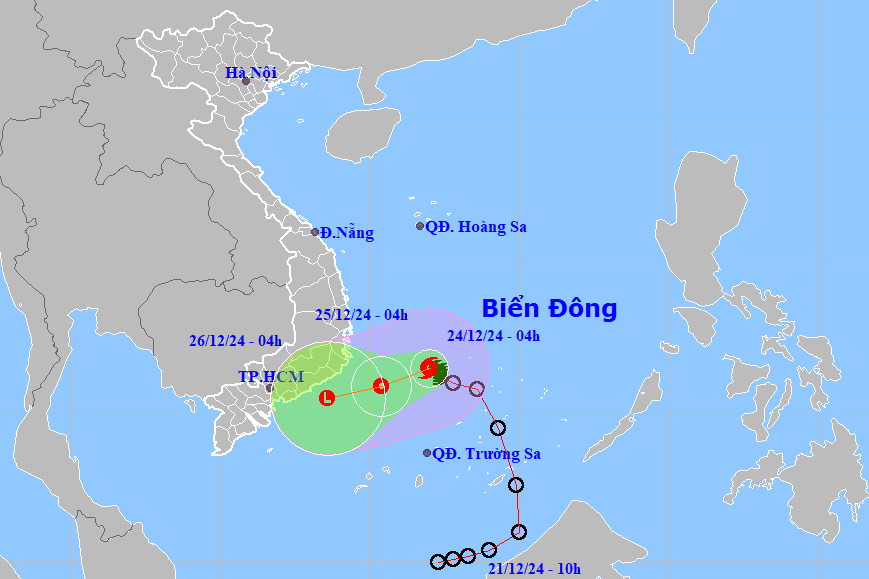
According to the National Center for Hydro-Meteorological Forecasting, at 4:00 a.m. this morning, December 24, the center of storm No. 10 (Pabuk) was located at about 11.5 degrees North latitude, 112.0 degrees East longitude, in the southwest sea area of the central East Sea.
The storm is moving west at a speed of 5-10km/h. The strongest wind near the storm center is level 8, gusting to level 10.
According to Deputy Director of the National Center for Hydro-Meteorological Forecasting Hoang Phuc Lam, the storm will weaken into a tropical depression when it moves south and is unlikely to affect the mainland of our country.
It is forecasted that in the next 24 hours, storm No. 10 will move in the West Southwest direction at a speed of 5-10km/h, gradually weakening into a tropical depression and continuing to weaken into a low pressure area in the next 48 hours.
Due to the impact of the storm, the southwestern sea area between the East Sea and the northwestern sea area of the South East Sea (including the northwestern sea area of Truong Sa archipelago) has strong winds of level 6-7, the area near the storm's center has strong winds of level 8, gusts of level 10, waves 4-6 m high; rough seas.
The sea area from Khanh Hoa to Binh Thuan (including Phu Quy island) has strong winds of level 6, sometimes level 7, gusting to level 8-9, waves 3-6 m high; rough seas.
Ships operating in the above mentioned dangerous areas are likely to be affected by storms, whirlwinds, strong winds and large waves.
Although coastal areas are not directly affected by strong winds of level 6-7, due to the storm combined with the Northeast monsoon, from the night of December 25, there will be moderate to heavy rain with common rainfall of about 60-150 mm, in some places over 250 mm.
The South Central and Southern regions are likely to have thunderstorms in the coming days. The Northern region will have favorable weather on December 24, and there may be light rain on the night of December 25.
According to the guidance of the Ministry of Agriculture and Rural Development, to proactively respond to the developments of the storm, ministries, branches, and Chairmen of the People's Committees of coastal provinces from Phu Yen to Ca Mau closely monitor the developments of the storm; strictly manage means of transport going out to sea; organize counting and notify owners of means of transport, captains of ships and boats operating at sea of the location, direction of movement and developments of the storm to proactively avoid, escape, not move into dangerous areas or return to safe shelters; based on the specific situation, decide to ban fishing boats, transport ships, and tourist boats from going to sea.
Ministries, sectors and localities are ready with forces and means for rescue when required. Ministries and sectors, according to their functions, state management tasks and assigned tasks, proactively direct and coordinate with localities to respond to the storm's developments.
Vietnam News Agency, Vietnam Television, Voice of Vietnam, coastal information stations and mass media agencies from central to local levels should strengthen measures to inform authorities at all levels and owners of vehicles operating at sea about the storm's developments so that they can proactively prevent and respond promptly and effectively...
TB

