


")

-d0772b57e88f948e139a9a67176fefdf.jpg "Forecast: Hai Duong is about to welcome the return of cold air")


.jpg "Kim Thanh reclaims more than 234 hectares of land to build an industrial park")


.jpg "Binh Giang's first quarter budget revenue reached nearly half of the province's annual target.")
.jpg "Early spring tea")
Submit a comment
In Hai Duong, due to the influence of the tropical convergence zone connecting with the tropical depression, from September 17-19, the weather will have scattered showers and thunderstorms, locally heavy rain. Thunderstorms are likely to cause tornadoes, lightning and strong gusts of wind.
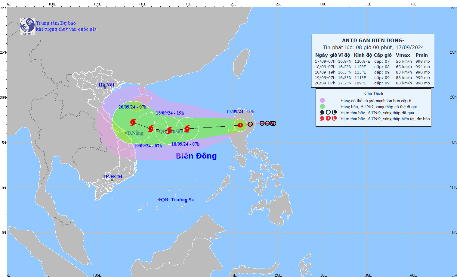
According to the National Center for Hydro-Meteorological Forecasting, at 7:00 a.m. on September 17, the center of the tropical depression was at about 16.9 degrees North latitude, 120.9 degrees East longitude, on the mainland of Luzon Island (Philippines).
The tropical depression moves mainly in a westerly direction at a speed of about 15-20 km/h. The strongest wind near the center of the tropical depression is level 7 (50-61 km/h), gusting to level 9.
At 7:00 a.m. on September 18, the tropical depression is forecast to move west-southwest at a speed of about 25 km/h into the East Sea, strengthening into a storm in the northern East Sea, about 270 km east of the Hoang Sa archipelago. The strongest wind near the storm center is level 8, gusting to level 10. The natural disaster risk level is level 3.
At 7:00 a.m. on September 19, the storm moved westward at a speed of about 15-20 km/h, in the western area of the Hoang Sa archipelago. The strongest wind near the storm center was level 9, gusting to level 10. The disaster risk level was level 3 in the northern East Sea (including the Hoang Sa archipelago).
In the next 48 to 72 hours, the storm is likely to change direction, moving in a West Northwest direction, traveling about 10km per hour.
Due to the impact of the storm, the eastern sea of the North East Sea has strong winds of level 6-7, the area near the storm's center has winds of level 8 (62-74km/h), gusts of level 10 (89-102km/h), and rough seas.
In Hai Duong, due to the influence of the tropical convergence zone connecting with the tropical depression near the East Sea with an axis through the Central region tending to lift the axis to the North combined with the southwest edge of the continental high pressure tongue, from September 17-19, the area in the province will have scattered showers and thunderstorms, locally heavy rain. During thunderstorms, there is a possibility of tornadoes, lightning and strong gusts of wind. Rainfall in places is commonly from 20-50mm, some places are higher.
From the afternoon of September 19, Hai Duong area is forecast to have scattered showers and thunderstorms, followed by rain in some places. Warning level of natural disaster risk due to tornadoes, lightning, hail, localized heavy rain: level 1.
TB


.jpg "Hai Duong's agricultural, forestry and fishery value increased by 7.51% in the first quarter.")