

.jpeg "Xuất hiện áp thấp nhiệt đới trên Biển Đông, nhiều nơi mưa lớn")
.jpeg "Chiều tối và đêm 13/7, Hải Dương có mưa rào và dông")


Submit a comment
According to the National Center for Hydro-Meteorological Forecasting, from the afternoon of July 14 to the night of July 15, in the plains and coastal areas of the North, North and Central Central regions, Central Highlands and the South, there will be moderate rain, heavy rain and thunderstorms, and locally very heavy rain.
The Northern Delta and coastal areas have common rainfall of 30-70 mm, locally over 100 mm. The North and Central Central regions have rainfall of 50-100 mm, locally over 200 mm. The Central Highlands and the South have rainfall of 40-90 mm, locally over 150 mm.
In addition, from July 14-18, in the Northwest and Viet Bac regions of the North, there will be scattered showers and thunderstorms, locally heavy to very heavy rain with rainfall from 15-30 mm/24 hours, locally over 80 mm/24 hours (rain concentrated in the evening and at night).
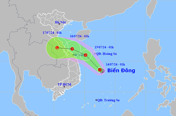
At 1:00 a.m. on July 14, the center of the tropical depression was at about 13.6 degrees North latitude; 112.5 degrees East longitude, in the western sea area of the central East Sea. The strongest wind near the center of the tropical depression was level 6 (39-49 km/h), gusting to level 8; moving northwest at a speed of 5-10 km/h.
In the next 48-72 hours, the tropical depression will move in the West Northwest direction, about 10 km per hour and gradually weaken.
Due to the influence of the tropical depression, the western sea area between the East Sea and the southwestern sea area of the North East Sea (including the Hoang Sa sea area) will have showers and thunderstorms, strong winds of level 6, then increasing to level 7, gusts of level 9, rough seas. The offshore sea area from Quang Tri to Binh Dinh will have strong winds of level 6-7, gusts of level 9, rough seas. Waves will be 2-4 m high.
Weather forecast for regions across the country:
Hanoi capital is cloudy, sunny during the day; cloudy in the evening and at night, with rain, moderate rain and thunderstorms, locally heavy rain. Southeast wind level 2-3. During thunderstorms, there is a possibility of tornadoes, lightning and strong gusts of wind. Lowest temperature 25-27 degrees Celsius. Highest temperature 33-35 degrees Celsius.
The Northwest is cloudy with scattered showers and thunderstorms; in the evening and at night, it is cloudy with scattered showers and thunderstorms, with some places experiencing heavy to very heavy rain. Light wind. During thunderstorms, there is a possibility of tornadoes, lightning, hail and strong gusts of wind. The lowest temperature is 24-27 degrees Celsius, with some places below 24 degrees Celsius. The highest temperature is 31-34 degrees Celsius, with some places above 34 degrees Celsius.
The Northeast region is cloudy with scattered showers and thunderstorms; in the evening and at night, it is cloudy with scattered showers and thunderstorms, locally heavy to very heavy rain, especially in the plains and coastal areas with moderate rain, heavy rain and scattered thunderstorms, locally very heavy rain. Southeast wind level 2-3. During thunderstorms, there is a possibility of tornadoes, lightning, hail and strong gusts of wind. The lowest temperature is 24-27 degrees Celsius, some places below 24 degrees Celsius. The highest temperature is 31-34 degrees Celsius, some places above 34 degrees Celsius.
The area from Thanh Hoa to Thua Thien-Hue is cloudy, sunny during the day; cloudy in the evening and at night, with moderate rain, heavy rain and scattered thunderstorms, locally very heavy rain. Southeast to east wind level 2-3. During thunderstorms, there is a possibility of tornadoes, lightning, hail and strong gusts of wind. Lowest temperature 24-27 degrees Celsius. Highest temperature 31-34 degrees Celsius.
Provinces and cities from Da Nang to Binh Thuan are cloudy with scattered showers and thunderstorms, locally heavy rain; in the North, in the late afternoon and at night, there will be moderate rain, heavy rain and scattered thunderstorms, locally very heavy rain. West to southwest winds level 2-3. During thunderstorms, there is a possibility of tornadoes, lightning, hail and strong gusts of wind. Lowest temperature 24-27 degrees Celsius. Highest temperature 30-33 degrees Celsius, some places above 33 degrees Celsius.
The Central Highlands region is cloudy with scattered showers and thunderstorms; in the afternoon and at night, it is cloudy with moderate rain, heavy rain and scattered thunderstorms, locally very heavy rain. Southwesterly winds level 2-3. There is a possibility of tornadoes, lightning, hail and strong gusts of wind during thunderstorms. The lowest temperature is 19-22 degrees Celsius. The highest temperature is 26-29 degrees Celsius, some places above 29 degrees Celsius.
The South is cloudy with scattered showers and thunderstorms; in the afternoon and at night, it is cloudy with moderate rain, heavy rain and scattered thunderstorms, locally very heavy rain. Southwesterly winds level 2-3. There is a possibility of tornadoes, lightning, hail and strong gusts of wind during thunderstorms. Lowest temperature 24-27 degrees Celsius. Highest temperature 29-32 degrees Celsius.